Wednesday April 15, 2020 - By Meteorologist Steve Hamilton
So, How Much Snow?
That's a tough question to answer right now, unfortunately. The forecast models are not lining up, even though this system appears similar to the last one. To put it simply, it doesn't seem like this will be a major two-footer for our area. Accumulations may end up between 3 and 8 inches for most areas, with lesser amounts for Denver.
A cold front is still expected to descend into Colorado from the Northern Rockies. We're seeing some snowfall in the northern mountains already, but this doesn't have much to do with the incoming front. It's more related to the current Jet Stream pattern, which has caused some "lifting" (pulling air up from the surface), and thus, some snowfall and gusty wind.
Looking at the front that's on the way, it should arrive over Colorado by this evening. Readings from further north show gusty wind behind the front, as is usually the case. We can expect that over the Front Range Foothills by this evening. Wind should be out of the north or northeast.
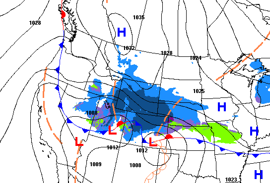
On the latest short and mid-range models, there looks to be enough moisture and lift, after the front passes, for us to see a few rain or snow showers during the early evening. As temperatures quickly cool, we'll start getting all snow showers, but they'll be scattered to start out with. The National Weather Service in Boulder has a Winter Weather Advisory is posted for most of the foothills until 6 PM Thursday night. A Winter Storm Warning covers most of the higher mountains, where more snow is expected, to the tune of a foot or more.
This system still has a lot of issues, with the various models disagreeing on timing of several factors. These include the amount of moist air available, and the arrival of stronger upper-level winds, which would increase snowfall for the foothills. There isn't much agreement right now on the timing, which is crucial, at least for tonight.
For Thursday morning, a lot will depend on where the stronger upper-level wind ends up. Right now, the models show it focusing further north, which means lesser amounts around here. But, (and there is almost always a "but" with this kind of stuff), even a slight change in the jet stream position could boost our snow totals over a short period of time. Surface wind direction and speed will also be an issue in determining how strong, and where, the best upslope conditions will end up. That will be another major component to ultimate snow totals for us.
As of now, it looks like the heavier snow will happen in the mountains tonight into Thursday night, where we could see over a foot, and possibly higher amounts by Thursday evening.
Like the last system, a band of snow will move north to south across the area behind the front. In any case, for the Front Range Foothills, we can expect snow totals in the 2 to 6 inch range. However, be prepared for a few more inches. Totals should stay under 8" for the most part. Snow shovels should take care of it.
As more model runs come in this afternoon and evening, there should be a much clearer picture, but what we've stated now seems most likely.
We won't look too much further ahead at this point. Rather, the focus is on this system, which should exit our area by Friday morning.