- Posts: 9186
- Thank you received: 209
Buffalo Peaks Weston Pass Fire
- MountainTownAlerts
-
 Topic Author
- Mountain Legend
-

Less
More
04 Jul 2018 22:44 #61
by MountainTownAlerts
Replied by MountainTownAlerts on topic Buffalo Peaks Weston Pass Fire
July 4, 2018 Evening Update
Today’s Fire Activity #westonpassfire
Containment on the fire has increased to 15%. The increase is on the north and northeast portion of the fire (Division D).
Today was another challenging weather day with a cold front predicted to create gusty erratic winds. Temperatures today warmed quickly into the mid 70s and relative humidity dipped to 10%. Showers developed in the vicinity of the fire early afternoon but produced no significant moisture. At 4:00 pm, winds shifted from the west to east-northeast. This marks the first time since Weston Pass Fire began that winds have come out of the east. This is good news for the Campground of the Rockies (CORA) as the winds are pushing fire away from US Hwy 285. However, these strong easterly winds are predicted for the next couple of days and now have compromised containment lines on the west side of the fire (Divisions A and Z).
The fire responded as predicted to the easterly wind shift and crossed primary control lines on the western portion (Division Z). For safety reasons firefighters moved to their predetermined safety areas. Due to the weather conditions, resources did not conduct firing operations today. The visible smoke columns were from increased fire activity after the wind shift.
Information Briefing: There will be a public briefing at 2:00 PM outside at Prather’s Grocery Store, 301 US Hwy 285, Fairplay. Public Information Officers will conduct these briefings on a daily basis.
Closures and Public Safety: A closure is in place one mile south of Fairplay at the junction of US Highway 285/State Highway 9 to all traffic, except local residents or landowners. A total closure is in place from the junction of US Highway 285/County Road 22 to Antero Junction. For up to date information visit www.cotrip.org . Evacuation status may change and evolve. For up to date information, please visit www.parkco.us .
Fire Statistics:
Location: 9 miles south of Fairplay, CO Percent Contained: 15%
Start Date: June 28, 2018 Total Personnel: Approximately 484
Size: 10,727 acres Cause: Lightning
Resources Include: Three Type 1 hand crews, 9 Type 2 hand crews, 14 engines, and 2 dozers
Helicopters: Three Type 1, two Type 3, and one fixed wing aircraft.
Weston Pass Fire Information
719-966-7842
Call Center Hours: 8 AM - 8 PM
E-mail: This email address is being protected from spambots. You need JavaScript enabled to view it.
Incident Information: inciweb.nwcg.gov/incident/5876/
Social Media: www.facebook.com/westonpassfire/
Please Log in or Create an account to join the conversation.
- MountainTownAlerts
-
Topic Author
- Mountain Legend
-
Less
More
- Posts: 9186
- Thank you received: 209
05 Jul 2018 09:18 - 05 Jul 2018 11:27 #62
by MountainTownAlerts
Replied by MountainTownAlerts on topic Buffalo Peaks Weston Pass Fire
Weston Pass Fire
7 mins ago
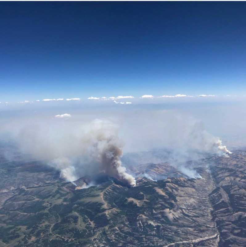
Sydney @SydHast 18 hours ago
#Fires in #Colorado taken from @SouthwestAir flight 560 on July 3. #springfire #ChateauFire #WestonPassFire #adobefire @KOAA #wildfire
Each of the links below take you to Facebook Albums by Bob Ensign who has some amazing photos of the fire and firefighters attacking it by air. Click on each to see the photos he's posted.
Weston Pass Fire. Part 1: Where There's Smoke...by Bob Ensign
Edit to add: video by Mark Godo of an Erickson Sky Crane with fire suppression kit lifting off from BV Airport to fight the Weston Pass fire.
www.facebook.com/mark.godo.1/videos/2514...f_t=group_highlights
7 mins ago
No updated acreage for #westonpassfire until Operations gathers GPS data on current fire perimeter this morning. Last nights infrared flight was not conducted due to cloud cover.
Due to yesterday's wind shift the fire did move west into the wilderness.
Sydney @SydHast 18 hours ago
#Fires in #Colorado taken from @SouthwestAir flight 560 on July 3. #springfire #ChateauFire #WestonPassFire #adobefire @KOAA #wildfire
Each of the links below take you to Facebook Albums by Bob Ensign who has some amazing photos of the fire and firefighters attacking it by air. Click on each to see the photos he's posted.
Weston Pass Fire. Part 1: Where There's Smoke...by Bob Ensign
Weston Pass Fire Part Two: Flames Take The Ridgeline by Bob EnsignThe Jones Hill Fire blew up today and was re-named The Weston Pass Fire. This is the first time I ever observed a Wildfire in its natural habitat, so naturally I wanted to get as close as possible. It turns out that in real life these critt'rs are Huge and Terrifying. I'd rather be eyeball-to-nose with a Bull Moose or a Bear than have a Wildfire like this in my own back yard and believe me, I speak from experience!
I shot my Canon until it ran out of ammunition (my batteries died in the line of duty.) I wound up taking over 400 pics, which I will be up all night editing. Stay tuned for Part Two: Flames! AND Part Three: Helicopter Heros! AND Part Four: Property in Peril!
This fire is still burning. Thoughts and prayers will do little good, but if anyone could bust out a good Rain Dance, we'd all appreciate it.
Weston Pass Fire Part 3: Aerial Assault. by Bob EnsignStrong winds goaded the fire to take the high ground. The flame seemed to explode across the skyline. Orange Daemons spinning wildly out of control, greedily & voraciously devouring everything in their path, like metaphors for Politics only vastly more terrifying.
Weston Pass Fire Part 4: Properties in Peril. by Bob EnsignThere are four or five homes in the path of the flames. If any are still there in the morning, it'll be thanks to These Guys for saving 'em. There were four helichoppers, at least three funny-looking slurry-dumpin' planes and one big slurry-bomber (I know nothing of aviation.).
Weston Pass Fire Part 5: Airpower! by Bob EnsignThe chopper pilots fought hard to protect several homes located along CR 22. I could see the residents evacuating ahead of the flames, but I do not know if the buildings were saved. I got a report this morning that wind had shifted and was no longer driving the fire downhill toward CR22. The smoke is still thick, but not rising in huge Pyrocumulous columns, like yesterday, according to my source in Fairplay.
Weston Pass Fire Part 6: Run Devil, Run! by Bob EnsignAs I observed the fire from my comfortable mezzanine-level vantage-point on Weston Pass Road, I was reminded of how, during the Civil War, townsfolk packed picnic lunches and sat down with the whole family to watch the carnage unfold at the Battle of Gettysburg. Plenty of Spectacle, Firepower and Heroics were on display for the 20 or so (mostly local) onlookers watching the Battle of Weston Pass with me yesterday. This fight is not over yet.
Even a mighty Dust-Devil is obliged to flee before the Inferno's onslaught. This feller is about 50 feet wide, spinning at around 50mph. It's hard to accurately guesstimate his height due to the intervening ridge, but all witnesses agreed he was probably several hundred feet tall the last time we saw him.
Edit to add: video by Mark Godo of an Erickson Sky Crane with fire suppression kit lifting off from BV Airport to fight the Weston Pass fire.
www.facebook.com/mark.godo.1/videos/2514...f_t=group_highlights
Last edit: 05 Jul 2018 11:27 by MountainTownAlerts.
Please Log in or Create an account to join the conversation.
- MountainTownAlerts
-
Topic Author
- Mountain Legend
-
Less
More
- Posts: 9186
- Thank you received: 209
05 Jul 2018 13:36 #63
by MountainTownAlerts
Replied by MountainTownAlerts on topic Buffalo Peaks Weston Pass Fire
Weston Pass Fire
1 hr ago
Today's plan described by Ken Gregor (Operations), Glen Lewis (Fire Behavior Analyst) and Mikah Hulme (Meterologist). Discussion covers today's planned firefighting activities and how weather affects those planned actions. #westonpassfire
ALERT: A flash flood watch issued for Weston Pass Fire Area 12 Noon-Midnight 7/5/18
Weston Pass Fire 7/5/18 AM Ops Briefing
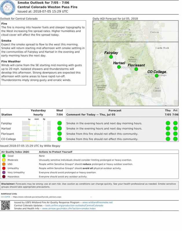
Smoke outlook for July 4 and 5 for Central Colorado, due to area wildfires.
July 5, 2018 (10:00 AM) Update
#westonpassfire
Weather
As predicted, yesterday afternoon the prevailing westerly winds shifted to the east. Last night’s increase in humidity and cloud cover will briefly slow fire intensity. The strong easterly winds predicted for the next couple of days will challenge firefighters on the west side of the fire (Divisions T and Z) . Slow moving scattered thunderstorms will move over the fire area this afternoon and evening. These storms may produce up to 1/2” of rain.
This weekend we are expecting higher temperatures into the upper 70’s, lower humidity and minimal precipitation. The winds will gradually shift from east to southeast and back to the northwest by Tuesday.
Current Situation
Acreage burned is 10,727 and containment is 15%. These numbers do not reflect yesterday’s growth. The east wind shift pushed the fire to the west yesterday past FS 433 into the Buffalo Peaks Wilderness. The exact amount of fire expansion to the west will be determined when the clouds lift allowing aircraft to fly the area.
The north and east sides of the fire continue to be secured and patrolled. Some resources have been moved to the west side of the fire. East winds are favorable for protecting the east side and CORA.
Along the south and west sides of the fire the operations team is assessing alternative control lines along FS 435 to the south and west up to Rough and Tumbling Creek (Div P, Div T, Div Z, Div A). The fire management objective remains full suppression. However as the fire moves into the Buffalo Peaks Wilderness fire suppression tactics will be adjusted accordingly.
Information Briefing: There will be a public briefing at 2:00 PM outside at Prather’s Grocery Store, 301 US Hwy 285, Fairplay. Public Information Officers will conduct these briefings on a daily basis.
Closures and Public Safety: A closure is in place one mile south of Fairplay at the junction of US Highway 285/State Highway 9 to all traffic, except local residents or landowners. A total closure is in place from the junction of US Highway 285/County Road 22 to Antero Junction. For up to date information visit www.cotrip.org . Evacuation status may change and evolve. For up to date information, please visit www.parkco.us .
Fire Statistics:
Location: 9 miles south of Fairplay, CO Percent Contained: 15%
Start Date: June 28, 2018 Total Personnel: Approximately 528
Size: 10,727 acres Cause: Lightning
Resources Include: Three Type 1 hand crews, 10 Type 2 hand crews, 18 engines, and 2 dozers
Helicopters: Three Type 1, one Type 2, two Type 3, and one fixed wing aircraft.
Weston Pass Fire Information
719-966-7842
Call Center Hours: 8 AM - 8 PM
E-mail: This email address is being protected from spambots. You need JavaScript enabled to view it.
Incident Information: inciweb.nwcg.gov/incident/5876/
Social Media: www.facebook.com/westonpassfire/
1 hr ago
Today's plan described by Ken Gregor (Operations), Glen Lewis (Fire Behavior Analyst) and Mikah Hulme (Meterologist). Discussion covers today's planned firefighting activities and how weather affects those planned actions. #westonpassfire
ALERT: A flash flood watch issued for Weston Pass Fire Area 12 Noon-Midnight 7/5/18
Weston Pass Fire 7/5/18 AM Ops Briefing
Smoke outlook for July 4 and 5 for Central Colorado, due to area wildfires.
July 5, 2018 (10:00 AM) Update
#westonpassfire
Weather
As predicted, yesterday afternoon the prevailing westerly winds shifted to the east. Last night’s increase in humidity and cloud cover will briefly slow fire intensity. The strong easterly winds predicted for the next couple of days will challenge firefighters on the west side of the fire (Divisions T and Z) . Slow moving scattered thunderstorms will move over the fire area this afternoon and evening. These storms may produce up to 1/2” of rain.
This weekend we are expecting higher temperatures into the upper 70’s, lower humidity and minimal precipitation. The winds will gradually shift from east to southeast and back to the northwest by Tuesday.
Current Situation
Acreage burned is 10,727 and containment is 15%. These numbers do not reflect yesterday’s growth. The east wind shift pushed the fire to the west yesterday past FS 433 into the Buffalo Peaks Wilderness. The exact amount of fire expansion to the west will be determined when the clouds lift allowing aircraft to fly the area.
The north and east sides of the fire continue to be secured and patrolled. Some resources have been moved to the west side of the fire. East winds are favorable for protecting the east side and CORA.
Along the south and west sides of the fire the operations team is assessing alternative control lines along FS 435 to the south and west up to Rough and Tumbling Creek (Div P, Div T, Div Z, Div A). The fire management objective remains full suppression. However as the fire moves into the Buffalo Peaks Wilderness fire suppression tactics will be adjusted accordingly.
Information Briefing: There will be a public briefing at 2:00 PM outside at Prather’s Grocery Store, 301 US Hwy 285, Fairplay. Public Information Officers will conduct these briefings on a daily basis.
Closures and Public Safety: A closure is in place one mile south of Fairplay at the junction of US Highway 285/State Highway 9 to all traffic, except local residents or landowners. A total closure is in place from the junction of US Highway 285/County Road 22 to Antero Junction. For up to date information visit www.cotrip.org . Evacuation status may change and evolve. For up to date information, please visit www.parkco.us .
Fire Statistics:
Location: 9 miles south of Fairplay, CO Percent Contained: 15%
Start Date: June 28, 2018 Total Personnel: Approximately 528
Size: 10,727 acres Cause: Lightning
Resources Include: Three Type 1 hand crews, 10 Type 2 hand crews, 18 engines, and 2 dozers
Helicopters: Three Type 1, one Type 2, two Type 3, and one fixed wing aircraft.
Weston Pass Fire Information
719-966-7842
Call Center Hours: 8 AM - 8 PM
E-mail: This email address is being protected from spambots. You need JavaScript enabled to view it.
Incident Information: inciweb.nwcg.gov/incident/5876/
Social Media: www.facebook.com/westonpassfire/
Please Log in or Create an account to join the conversation.
- MountainTownAlerts
-
Topic Author
- Mountain Legend
-
Less
More
- Posts: 9186
- Thank you received: 209
05 Jul 2018 15:17 #64
by MountainTownAlerts
Replied by MountainTownAlerts on topic Buffalo Peaks Weston Pass Fire
Weston Pass Fire
10 mins ago
Currently 12,939 acres and 15% contained. #westonpassfire acreage has been updated following a flight this morning.
www.facebook.com/westonpassfire
Weston Pass Fire
28 mins ago
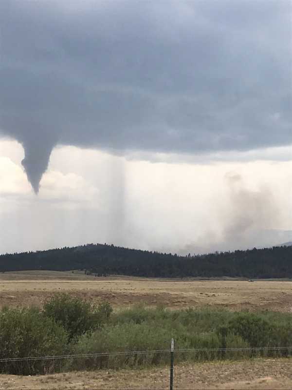
Hail in Division Z following the passage of a tornado over the fire area. #westonpassfire
Weston Pass Fire
39 mins ago
A tornado moved across the fire area at approximately 1:45 pm. Firefighters went to paved or gravel roads during the tornadic activity. There were also trees uprooted. No injuries were reported. #westonpassfire
10 mins ago
Currently 12,939 acres and 15% contained. #westonpassfire acreage has been updated following a flight this morning.
www.facebook.com/westonpassfire
Weston Pass Fire
28 mins ago
Hail in Division Z following the passage of a tornado over the fire area. #westonpassfire
Weston Pass Fire
39 mins ago
A tornado moved across the fire area at approximately 1:45 pm. Firefighters went to paved or gravel roads during the tornadic activity. There were also trees uprooted. No injuries were reported. #westonpassfire
Please Log in or Create an account to join the conversation.
- MountainTownAlerts
-
Topic Author
- Mountain Legend
-
Less
More
- Posts: 9186
- Thank you received: 209
05 Jul 2018 18:32 #65
by MountainTownAlerts
Replied by MountainTownAlerts on topic Buffalo Peaks Weston Pass Fire
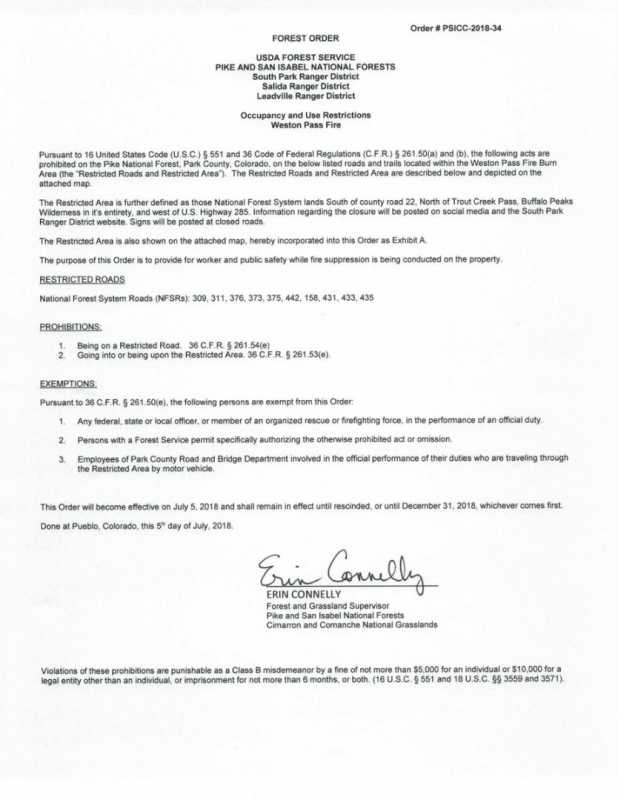
USFS_Pike&San Isabel @PSICC_NF 12 minutes ago
WESTON PASS FIRE CLOSURE ORDER:
The Weston Pass Fire has moved into Buffalo Peaks Wilderness area. The closure area has expanded within the South Park, Salida, and Leadville Ranger Districts.
#SouthParkRD #SalidaRD #LeadvilleRD #WestonPassFire

Weston Pass Fire Public Briefing Video
WESTON PASS FIRE CLOSURE ORDER:
The Weston Pass Fire has moved into Buffalo Peaks Wilderness area. The closure area has expanded within the South Park, Salida, and Leadville Ranger Districts.
#SouthParkRD #SalidaRD #LeadvilleRD #WestonPassFire
Weston Pass Fire Public Briefing Video
Please Log in or Create an account to join the conversation.
- MountainTownAlerts
-
Topic Author
- Mountain Legend
-
Less
More
- Posts: 9186
- Thank you received: 209
05 Jul 2018 19:06 #66
by MountainTownAlerts
Replied by MountainTownAlerts on topic Buffalo Peaks Weston Pass Fire
Weston Pass Fire
26 mins ago
July 5, 2018 Evening Update
#westonpassfire
Today’s Fire Activity
Current acreage is 12,902; containment on the fire has increased to 17%.
Thunderstorms were anticipated over the fire today, however an unexpected tornadic event resulted in crews leaving the line for safety reasons. There were reports of uprooted trees in Division P and hail in Division Z; there were no reports of injuries. Tomorrow’s forecast calls for calmer weather, partly cloudy in the morning and mostly cloudy in the afternoon. There will also be thundershowers and thunderstorms late morning and early afternoon.
Division A is identifying contingency lines to the northwest of the fire and continues to hold and mopup along the fire perimeter. On the north side of the fire crews continued to mop up and secure line around structures and along the fire perimeter (Div D, Div M). Mop up is extinguishing or removing burning material near control lines, felling snags, and trenching logs to prevent rolling after an area has burned. On the south side of the fire, crews went direct to cut line along the current fire perimeter (Div P). To the southwest firefighters are identifying contingency lines and securing line from yesterdays fire activity (Div P, Div T). Division Z is holding the fire perimeter on the western flank. A swing shift was added to assist on the west flank. The night shift will patrol structures in Divisions A and M.
Information Briefing: There will be a public briefing at 2:00 PM outside at Prather’s Grocery Store, 301 US Hwy 285, Fairplay. Public Information Officers will conduct these briefings on a daily basis.
Closures and Public Safety: A closure is in place one mile south of Fairplay at the junction of US Highway 285/State Highway 9 to all traffic, except local residents or landowners. A total closure is in place from the junction of US Highway 285/County Road 22 to Antero Junction. For up to date information visit www.cotrip.org . Evacuation status may change and evolve. For up to date information, please visit www.parkco.us .
Fire Statistics:
Location: 9 miles south of Fairplay, CO Percent Contained: 17%
Start Date: June 28, 2018 Total Personnel: Approximately 591
Size: 12,902 acres Cause: Lightning
Resources Include: Three Type 1 hand crews, 10 Type 2 hand crews, 24 engines, and 2 dozers
Helicopters: Three Type 1, one Type 2, three Type 3 and two fixed wing aircraft.
Weston Pass Fire Information
719-966-7842
Call Center Hours: 8 AM - 8 PM
E-mail: This email address is being protected from spambots. You need JavaScript enabled to view it.
Incident Information: inciweb.nwcg.gov/incident/5876/
Social Media: www.facebook.com/westonpassfire/
Please Log in or Create an account to join the conversation.
- MountainTownAlerts
-
Topic Author
- Mountain Legend
-
Less
More
- Posts: 9186
- Thank you received: 209
06 Jul 2018 09:28 #67
by MountainTownAlerts
Replied by MountainTownAlerts on topic Buffalo Peaks Weston Pass Fire
7/6/18 Morning Info
Weston Pass Fire Wildfire
Announcements – 1:35 hrs. ago
Currently 12,902 acres and 17% contained. The fire moved into the Buffalo Peaks Wilderness Area yesterday which is now closed to public entry. #westonpassfire
Weston Pass Fire Wildfire
Announcements – 1:35 hrs. ago
Currently 12,902 acres and 17% contained. The fire moved into the Buffalo Peaks Wilderness Area yesterday which is now closed to public entry. #westonpassfire
Please Log in or Create an account to join the conversation.
- MountainTownAlerts
-
Topic Author
- Mountain Legend
-
Less
More
- Posts: 9186
- Thank you received: 209
06 Jul 2018 10:55 #68
by MountainTownAlerts
Replied by MountainTownAlerts on topic Buffalo Peaks Weston Pass Fire
Weston Pass Fire
6 mins ago
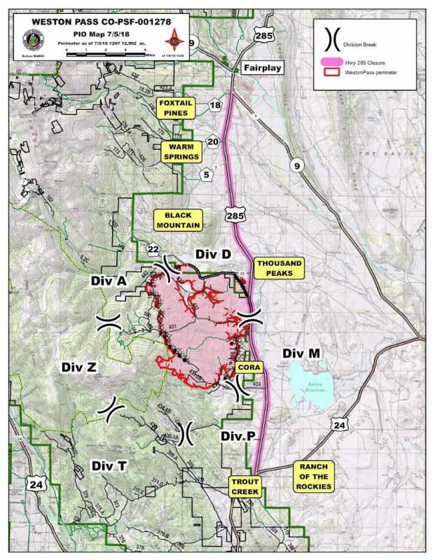
7/6/2018 Weston Pass Fire Map

July 6, 2018 (10:00 AM)
#WestonPassFire
Weather
Spotty moisture from yesterday and higher humidity (90-97%) last night may result in reduced fire activity today. Remote Automated Weather Station (RAWS) reported .17” and crews had to pull vehicles back to hard surface roads during the rain. The inversion is expected to lift around 10 AM. Temperatures will be in the mid 70s with relative humidity of 27-32%. Clouds will move in around noon with gusty winds from the SE bringing the possibility of showers and afternoon thunderstorms.
Current Situation
After the fire breached the boundary of the Buffalo Peaks Wilderness, the Forest Service issued a closure for the entire Wilderness area. Yesterday, fire personnel identified primary and alternate contingency lines on the south, west and northwest sides of the fire. Today these lines will be the focus of work in these areas. Hard work by firefighters, weather and SE wind direction continue to line up a positive outlook for CORA.
Division A has identified Rough and Tumble Creek as the primary contingency line. Crews will be improving the alternate contingency line north and east to tie in with Highway 22. Crews will continue to secure and mop up along the contained line in Divisions D and M, while identifying and removing fire damaged, dangerous trees. Division P is directly fighting the fire south of FS 433 and constructing indirect/alternate contingency line from FS 433 to the wilderness boundary in order to keep the fire north of FS 435. Division T will be prepping the FS 435 road to the North Salt Creek Trailhead. Hot Shot crews are on the ground in the Wilderness area (Div Z) assessing risks and possible options for suppression. Structure Group will continue to monitor and assess structures in the vicinity of the fire. Swing shift resources will be assigned as needs present depending on weather and fire activity.
Information Briefings
Public Information Officers will conduct daily briefings at 2:00 PM outside at Prather’s Grocery Store, 301 US Hwy 285, Fairplay and at 3:00 PM outside at Buena Vista Chamber of Commerce and Visitors Center, 343 US 24, Buena Vista.
Closures and Public Safety: A closure is in place one mile south of Fairplay at the junction of US Highway 285/State Highway 9 to all traffic, except local residents or landowners. A total closure is in place from the junction of US Highway 285/County Road 22 to Antero Junction. For up to date information visit www.cotrip.org . Evacuation status may change and evolve. For up to date information, please visit www.parkco.us . . Buffalo Peaks Wilderness Area is closed until further notice.
Fire Statistics:
Location: 9 miles south of Fairplay, CO Percent Contained: 17%
Start Date: June 28, 2018 Total Personnel: Approximately 591
Size: 12,902 acres Cause: Lightning
Resources Include: Three Type 1 hand crews, 10 Type 2 hand crews, 24 engines, and 2 dozers
Helicopters: Three Type 1, one Type 2, two Type 3, and two fixed wing aircraft.
Weston Pass Fire Information
719-966-7842
Call Center Hours: 8 AM - 8 PM
E-mail: This email address is being protected from spambots. You need JavaScript enabled to view it.
Incident Information: inciweb.nwcg.gov/incident/5876/
Social Media: www.facebook.com/westonpassfire/
6 mins ago
7/6/2018 Weston Pass Fire Map
July 6, 2018 (10:00 AM)
#WestonPassFire
Weather
Spotty moisture from yesterday and higher humidity (90-97%) last night may result in reduced fire activity today. Remote Automated Weather Station (RAWS) reported .17” and crews had to pull vehicles back to hard surface roads during the rain. The inversion is expected to lift around 10 AM. Temperatures will be in the mid 70s with relative humidity of 27-32%. Clouds will move in around noon with gusty winds from the SE bringing the possibility of showers and afternoon thunderstorms.
Current Situation
After the fire breached the boundary of the Buffalo Peaks Wilderness, the Forest Service issued a closure for the entire Wilderness area. Yesterday, fire personnel identified primary and alternate contingency lines on the south, west and northwest sides of the fire. Today these lines will be the focus of work in these areas. Hard work by firefighters, weather and SE wind direction continue to line up a positive outlook for CORA.
Division A has identified Rough and Tumble Creek as the primary contingency line. Crews will be improving the alternate contingency line north and east to tie in with Highway 22. Crews will continue to secure and mop up along the contained line in Divisions D and M, while identifying and removing fire damaged, dangerous trees. Division P is directly fighting the fire south of FS 433 and constructing indirect/alternate contingency line from FS 433 to the wilderness boundary in order to keep the fire north of FS 435. Division T will be prepping the FS 435 road to the North Salt Creek Trailhead. Hot Shot crews are on the ground in the Wilderness area (Div Z) assessing risks and possible options for suppression. Structure Group will continue to monitor and assess structures in the vicinity of the fire. Swing shift resources will be assigned as needs present depending on weather and fire activity.
Information Briefings
Public Information Officers will conduct daily briefings at 2:00 PM outside at Prather’s Grocery Store, 301 US Hwy 285, Fairplay and at 3:00 PM outside at Buena Vista Chamber of Commerce and Visitors Center, 343 US 24, Buena Vista.
Closures and Public Safety: A closure is in place one mile south of Fairplay at the junction of US Highway 285/State Highway 9 to all traffic, except local residents or landowners. A total closure is in place from the junction of US Highway 285/County Road 22 to Antero Junction. For up to date information visit www.cotrip.org . Evacuation status may change and evolve. For up to date information, please visit www.parkco.us . . Buffalo Peaks Wilderness Area is closed until further notice.
Fire Statistics:
Location: 9 miles south of Fairplay, CO Percent Contained: 17%
Start Date: June 28, 2018 Total Personnel: Approximately 591
Size: 12,902 acres Cause: Lightning
Resources Include: Three Type 1 hand crews, 10 Type 2 hand crews, 24 engines, and 2 dozers
Helicopters: Three Type 1, one Type 2, two Type 3, and two fixed wing aircraft.
Weston Pass Fire Information
719-966-7842
Call Center Hours: 8 AM - 8 PM
E-mail: This email address is being protected from spambots. You need JavaScript enabled to view it.
Incident Information: inciweb.nwcg.gov/incident/5876/
Social Media: www.facebook.com/westonpassfire/
Please Log in or Create an account to join the conversation.
- MountainTownAlerts
-
Topic Author
- Mountain Legend
-
Less
More
- Posts: 9186
- Thank you received: 209
06 Jul 2018 19:09 #69
by MountainTownAlerts
Replied by MountainTownAlerts on topic Buffalo Peaks Weston Pass Fire
Weston Pass Fire
27 mins ago
July 6, 2018 Evening Update
#westonpassfire
Today’s Fire Activity
Current acreage is 12,902; containment on the fire has increased to 32%.
Severe weather including thunderstorms and cloud to ground lightning impacted the fire this afternoon. Line personnel moved to staging areas and remained in vehicles until the storm passed before engaging the fire again. Saturday’s forecast calls for a mostly sunny morning with the inversion lifting around 10 AM. Winds are expected from the NE 5-10 mph with gusts up to 15 mph. Clouds and possible thundershowers will develop after 1:00 PM. High temperatures are expected in mid 70’s with 20% humidity and 30% chance of rain.
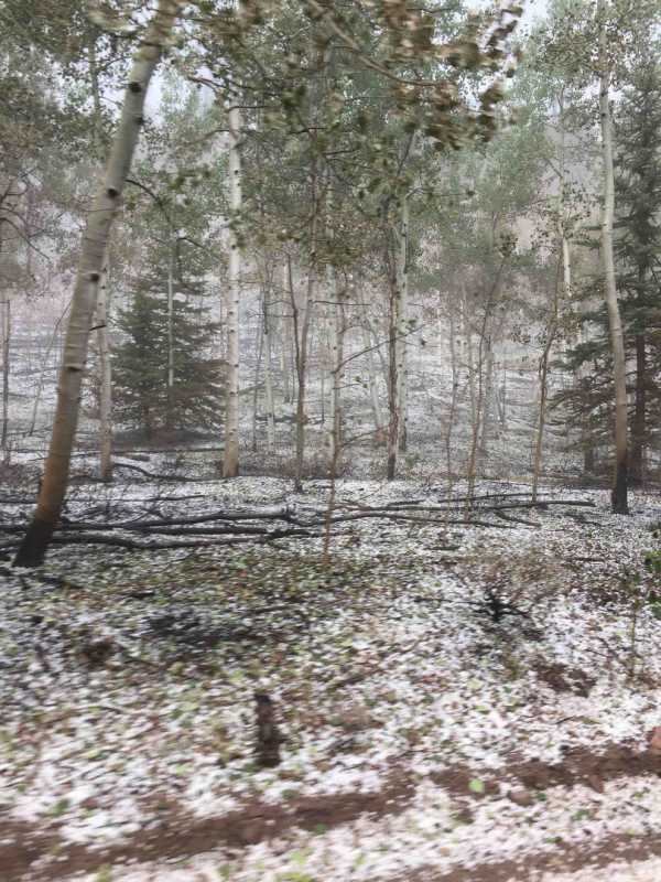
Crews continued to improve alternate contingency lines in Divisions A, P and T. Helicopters were active dropping several loads of water along the southern edge of the fire allowing crews to work the primary line. Several snags (fire damaged trees) were removed in Division D and M. In Division P near the Wilderness crews went direct (building fire line directly adjacent to the fire edge) with dozers south of FS 433 and constructed contingency line from FS 435 to the Wilderness boundary. In Division Z where the fire breached the Wilderness, hotshot crews assessed viability of going direct. Conclusion was that risk was too great and potential of success was too low.
This afternoon, Ken Gregor, Operations Section Chief and Glen Lewis, Fire Behavior Analyst, flew the entire perimeter of the fire broadcasting live on FaceBook. This 22 minute recording showed how the fire burned in a spotty or mosaic pattern, where the fire burned into the Buffalo Peaks Wilderness (which precipitated the closing of the Wilderness) as well as the status of Camp Ground of the Rockies (CORA). Ken responded live to citizen’s questions asked during the broadcast.
Information Briefing:
Public Information Officers will conduct daily briefings at 2:00 PM outside at Prather’s Grocery Store, 301 US Hwy 285, Fairplay and at 3:00 PM outside at Buena Vista Chamber of Commerce and Visitors Center, 343 US 24, Buena Vista.
Closures and Public Safety: A closure is in place one mile south of Fairplay at the junction of US Highway 285/State Highway 9 to all traffic, except local residents or landowners. A total closure is in place from the junction of US Highway 285/County Road 22 to Antero Junction. For up to date information visit www.cotrip.org . Evacuation status may change and evolve. For up to date information, please visit www.parkco.us . Buffalo Peaks Wilderness Area is closed until further notice.
Fire Statistics:
Location: 9 miles south of Fairplay, CO Percent Contained: 32%
Start Date: June 28, 2018 Total Personnel: Approximately 597
Size: 12,902 acres Cause: Lightning
Resources Include: Three Type 1 hand crews, 10 Type 2 hand crews, 23 engines, and 2 dozers
Helicopters: Four Type 1, one Type 2, three Type 3 and two fixed wing aircraft.
Weston Pass Fire Information
719-966-7842
Call Center Hours: 8 AM - 8 PM
E-mail: This email address is being protected from spambots. You need JavaScript enabled to view it.
Incident Information: inciweb.nwcg.gov/incident/5876/
Social Media: www.facebook.com/westonpassfire/
27 mins ago
July 6, 2018 Evening Update
#westonpassfire
Today’s Fire Activity
Current acreage is 12,902; containment on the fire has increased to 32%.
Severe weather including thunderstorms and cloud to ground lightning impacted the fire this afternoon. Line personnel moved to staging areas and remained in vehicles until the storm passed before engaging the fire again. Saturday’s forecast calls for a mostly sunny morning with the inversion lifting around 10 AM. Winds are expected from the NE 5-10 mph with gusts up to 15 mph. Clouds and possible thundershowers will develop after 1:00 PM. High temperatures are expected in mid 70’s with 20% humidity and 30% chance of rain.
Crews continued to improve alternate contingency lines in Divisions A, P and T. Helicopters were active dropping several loads of water along the southern edge of the fire allowing crews to work the primary line. Several snags (fire damaged trees) were removed in Division D and M. In Division P near the Wilderness crews went direct (building fire line directly adjacent to the fire edge) with dozers south of FS 433 and constructed contingency line from FS 435 to the Wilderness boundary. In Division Z where the fire breached the Wilderness, hotshot crews assessed viability of going direct. Conclusion was that risk was too great and potential of success was too low.
This afternoon, Ken Gregor, Operations Section Chief and Glen Lewis, Fire Behavior Analyst, flew the entire perimeter of the fire broadcasting live on FaceBook. This 22 minute recording showed how the fire burned in a spotty or mosaic pattern, where the fire burned into the Buffalo Peaks Wilderness (which precipitated the closing of the Wilderness) as well as the status of Camp Ground of the Rockies (CORA). Ken responded live to citizen’s questions asked during the broadcast.
Information Briefing:
Public Information Officers will conduct daily briefings at 2:00 PM outside at Prather’s Grocery Store, 301 US Hwy 285, Fairplay and at 3:00 PM outside at Buena Vista Chamber of Commerce and Visitors Center, 343 US 24, Buena Vista.
Closures and Public Safety: A closure is in place one mile south of Fairplay at the junction of US Highway 285/State Highway 9 to all traffic, except local residents or landowners. A total closure is in place from the junction of US Highway 285/County Road 22 to Antero Junction. For up to date information visit www.cotrip.org . Evacuation status may change and evolve. For up to date information, please visit www.parkco.us . Buffalo Peaks Wilderness Area is closed until further notice.
Fire Statistics:
Location: 9 miles south of Fairplay, CO Percent Contained: 32%
Start Date: June 28, 2018 Total Personnel: Approximately 597
Size: 12,902 acres Cause: Lightning
Resources Include: Three Type 1 hand crews, 10 Type 2 hand crews, 23 engines, and 2 dozers
Helicopters: Four Type 1, one Type 2, three Type 3 and two fixed wing aircraft.
Weston Pass Fire Information
719-966-7842
Call Center Hours: 8 AM - 8 PM
E-mail: This email address is being protected from spambots. You need JavaScript enabled to view it.
Incident Information: inciweb.nwcg.gov/incident/5876/
Social Media: www.facebook.com/westonpassfire/
The following user(s) said Thank You: joecolorado
Please Log in or Create an account to join the conversation.
- MountainTownAlerts
-
Topic Author
- Mountain Legend
-
Less
More
- Posts: 9186
- Thank you received: 209
07 Jul 2018 08:41 - 07 Jul 2018 08:53 #70
by MountainTownAlerts
Replied by MountainTownAlerts on topic Buffalo Peaks Weston Pass Fire
CDOT Verified account @ColoradoDOT
8:26am
US 285 NOW OPEN between Fairplay and Antero Junction(mp 188 to 163). The Weston Fire is still burning and only partially contained, however it is no longer a threat to the highway. Motorists should be aware at times there is still heavy smoke in the area, decreasing visibility.
Edit to add:
CDOT Verified account @ColoradoDOT 35 minutes ago
US 285: Fire department activity between US 24 (Antero Junction) and County Road 18 (near Fairplay). Slower speeds, due to heavy smoke and fire crews activity
Last edit: 07 Jul 2018 08:53 by MountainTownAlerts.
Please Log in or Create an account to join the conversation.
Time to create page: 0.299 seconds
sponsors

