- Posts: 9187
- Thank you received: 209
- Forum
- Life Up the Hill
- Scanner & Emergency Info, Weather Forecasts
- Red Flag Warning Saturday 10am-7pm September 29; Burn Ban Park County
Red Flag Warning Saturday 10am-7pm September 29; Burn Ban Park County
- MountainTownAlerts
-
 Topic Author
- Mountain Legend
-

Less
More
28 Sep 2018 16:36 - 29 Sep 2018 09:18 #1
by MountainTownAlerts
Red Flag Warning Saturday 10am-7pm September 29; Burn Ban Park County was created by MountainTownAlerts
From Platte Canyon Fire:
RED FLAG WARNING HAS BEEN ISSUED.
#PCFPD in a BURN BAN, EFFECTIVE IMMEDIATELY.
THANK YOU for your cooperation & help.
URGENT - FIRE WEATHER MESSAGE...UPDATED
National Weather Service Denver/Boulder CO
1032 AM MDT Fri Sep 28 2018
...CRITICAL FIRE WEATHER CONDITIONS ARE LIKELY SATURDAY SATURDAY AFTERNOON FOR HIGHER ELEVATIONS IN NORTH CENTRAL COLORADO...
.A swift westerly flow aloft and gusty west-southwest surface winds will combine with unseasonably warm temperatures, low relative humidity and ample sunshine to produce critical fire behavior conditions in the mountains, Front Range foothills and high mountain valleys in north central Colorado Saturday afternoon. The Ryan and Silver Creek wildfires may be particularly impacted by these critical fireweather conditions. These conditions are expected to improve Saturday evening with higher humidities and lighter wind speeds.
COZ211-213-214-290045-
/O.UPG.KBOU.FW.A.0021.180929T1800Z-180930T0000Z/
/O.NEW.KBOU.FW.W.0041.180929T1800Z-180930T0000Z/
Jackson County Below 9000 Feet-
Grand and Summit Counties Below 9000 Feet-
Central and Southeast Park County-
1032 AM MDT Fri Sep 28 2018
...RED FLAG WARNING IN EFFECT FROM NOON TO 6 PM MDT SATURDAY FOR WIND AND LOW RELATIVE HUMIDITY FOR HIGH MOUNTAIN VALLEYS IN NORTH CENTRAL COLORADO......
The National Weather Service in Denver has issued a Red Flag Warning FOR WIND AND LOW RELATIVE HUMIDITY, which is in effect from noon to 6 PM MDT Saturday. The Fire Weather Watch is no longer in effect.
* Affected Area...Fire Weather Zones 211...213 and 214.
* Winds...West 15 to 20 mph with gusts up to 35 mph.
* Timing...Saturday from 1200 to 1800 MDT.
* Relative Humidity...As low as 10 percent.
* Impacts...Any existing fires including the Ryan Fire and Silver Creek Fire will be prone to rapid growth and dangerous fire behavior. New fires may also start and spread rapidly should these critical fireweather conditions develop.
PRECAUTIONARY/PREPAREDNESS ACTIONS...
A Red Flag Warning means that critical fire weather conditions are either occurring now....or will shortly. A combination of strong winds...low relative humidity...and warm temperatures can contribute to extreme fire behavior.
Last edit: 29 Sep 2018 09:18 by MountainTownAlerts. Reason: updated time
Please Log in or Create an account to join the conversation.
- MountainTownAlerts
-
Topic Author
- Mountain Legend
-
Less
More
- Posts: 9187
- Thank you received: 209
29 Sep 2018 09:19 #2
by MountainTownAlerts
Replied by MountainTownAlerts on topic Red Flag Warning Saturday 10am-7pm September 29; Burn Ban Park County
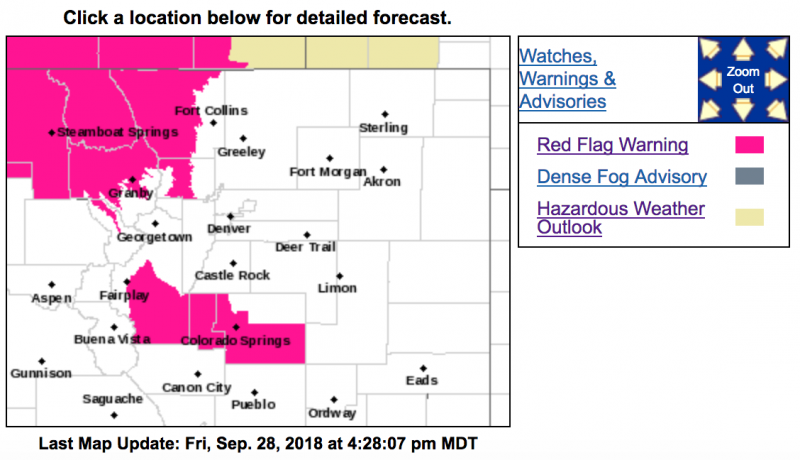
The Red Flag Warning has been expanded to include Jeffco, Clear Creek County and all of Park County, and goes from 10am-7pm now. No open burning today please! Read below for details:
NWS Boulder Verified account @NWSBoulder 3 hours ago
A Red Flag Warning will be in effect from 10am to 7pm today. Please do not burn! High temps in Denver will be roughly 35° warmer than yesterday. #COwx
Red Flag Warning
URGENT - FIRE WEATHER MESSAGE
National Weather Service Denver/Boulder CO
443 AM MDT Sat Sep 29 2018
...RED FLAG WARNING FOR THE NORTHERN COLORADO MOUNTAINS TODAY...
.A warm and very dry airmass will combine with strong westerly winds to bring very high to extreme fire danger across the northern Colorado mountains today. The winds and low humidities will develop in some areas this morning and become widespread by early afternoon. The Ryan and Silver Creek wildfires will be impacted by these conditions. There will be a slow improvement in humidity this evening, with winds decreasing in the valleys, but it will remain windy over the ridges overnight tonight.
COZ212-216-292100-
/O.EXB.KBOU.FW.W.0041.180929T1600Z-180930T0100Z/
South and Southeast Grand/West Central and Southwest Boulder/
Gilpin/Clear Creek/Summit/North and West Park Counties Above
9000 Feet-
Jefferson and West Douglas Counties Above 6000 Feet/Gilpin/Clear
Creek/Northeast Park Counties Below 9000 Feet-
443 AM MDT Sat Sep 29 2018
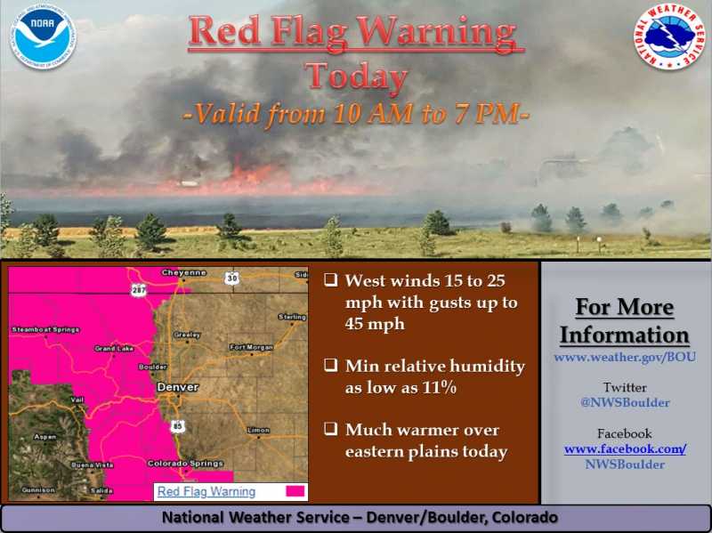
...RED FLAG WARNING IN EFFECT FROM 10 AM THIS MORNING TO 7 PM MDT THIS EVENING FOR WIND AND LOW RELATIVE HUMIDITY FOR FIRE WEATHER ZONES 212 AND 216...THE MOUNTAINS FROM BERTHOUD PASS SOUTH TO SUMMIT COUNTY AND THE SOUTHERN FRONT RANGE FOOTHILLS...
The National Weather Service in Denver has issued a Red Flag Warning FOR WIND AND LOW RELATIVE HUMIDITY, which is in effect from 10 AM this morning to 7 PM MDT this evening.
* Affected Area...Fire Weather Zones 212 and 216.
* Winds...West 15 to 25 mph with gusts up to 45 mph.
* Timing...Today from 1000 to 1900 MDT. Strong winds and low humidities will develop over the higher ridges and east slopes this morning, then spread into the valleys and lower foothills by early afternoon.
* Relative Humidity...As low as 11 percent.
* Impacts...Fires will start easily and spread rapidly.
PRECAUTIONARY/PREPAREDNESS ACTIONS...
A Red Flag Warning means that critical fire weather conditions are either occurring now....or will shortly. A combination of strong winds...low relative humidity...and warm temperatures can
contribute to extreme fire behavior.
NWS Boulder Verified account @NWSBoulder 3 hours ago
A Red Flag Warning will be in effect from 10am to 7pm today. Please do not burn! High temps in Denver will be roughly 35° warmer than yesterday. #COwx
Red Flag Warning
URGENT - FIRE WEATHER MESSAGE
National Weather Service Denver/Boulder CO
443 AM MDT Sat Sep 29 2018
...RED FLAG WARNING FOR THE NORTHERN COLORADO MOUNTAINS TODAY...
.A warm and very dry airmass will combine with strong westerly winds to bring very high to extreme fire danger across the northern Colorado mountains today. The winds and low humidities will develop in some areas this morning and become widespread by early afternoon. The Ryan and Silver Creek wildfires will be impacted by these conditions. There will be a slow improvement in humidity this evening, with winds decreasing in the valleys, but it will remain windy over the ridges overnight tonight.
COZ212-216-292100-
/O.EXB.KBOU.FW.W.0041.180929T1600Z-180930T0100Z/
South and Southeast Grand/West Central and Southwest Boulder/
Gilpin/Clear Creek/Summit/North and West Park Counties Above
9000 Feet-
Jefferson and West Douglas Counties Above 6000 Feet/Gilpin/Clear
Creek/Northeast Park Counties Below 9000 Feet-
443 AM MDT Sat Sep 29 2018
...RED FLAG WARNING IN EFFECT FROM 10 AM THIS MORNING TO 7 PM MDT THIS EVENING FOR WIND AND LOW RELATIVE HUMIDITY FOR FIRE WEATHER ZONES 212 AND 216...THE MOUNTAINS FROM BERTHOUD PASS SOUTH TO SUMMIT COUNTY AND THE SOUTHERN FRONT RANGE FOOTHILLS...
The National Weather Service in Denver has issued a Red Flag Warning FOR WIND AND LOW RELATIVE HUMIDITY, which is in effect from 10 AM this morning to 7 PM MDT this evening.
* Affected Area...Fire Weather Zones 212 and 216.
* Winds...West 15 to 25 mph with gusts up to 45 mph.
* Timing...Today from 1000 to 1900 MDT. Strong winds and low humidities will develop over the higher ridges and east slopes this morning, then spread into the valleys and lower foothills by early afternoon.
* Relative Humidity...As low as 11 percent.
* Impacts...Fires will start easily and spread rapidly.
PRECAUTIONARY/PREPAREDNESS ACTIONS...
A Red Flag Warning means that critical fire weather conditions are either occurring now....or will shortly. A combination of strong winds...low relative humidity...and warm temperatures can
contribute to extreme fire behavior.
Please Log in or Create an account to join the conversation.
- Forum
- Life Up the Hill
- Scanner & Emergency Info, Weather Forecasts
- Red Flag Warning Saturday 10am-7pm September 29; Burn Ban Park County
Time to create page: 0.179 seconds
sponsors

