- Posts: 46
- Thank you received: 14
Hurricane Patricia
- Chief Meteorologist
-
 Topic Author
- Happy Camper
-

Less
More
23 Oct 2015 17:26 #1
by Chief Meteorologist
Hurricane Patricia was created by Chief Meteorologist
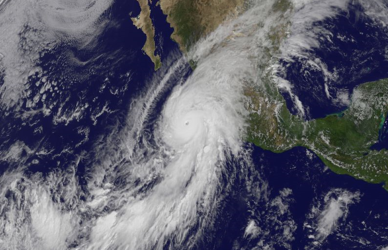
Hey Friends. Here's the latest on Hurricane Patricia. It is just about to make landfall south of Puerto Vallarta, Mexico. This is the strongest hurricane recorded in the eastern Pacific. Prior to landfall, it was a Category 5 with winds of 200 mph. Just before landfall, the storm weakened a little to winds of 190 mph, which is still extremely dangerous.
Resort areas affected by Patricia will be Puerto Vallarta and the surrounding resorts, and also Mazatlan. The damage will be three-fold: 1. Storm Surge. This will damage the beach areas and cause sand erosion due to sea water being pushed inland by the storm's strong wind. 2. Flash Flooding. We are predicting 8 to 12 inches of rain within 100 miles of landfall, and locally higher amounts in the mountainous terrain to the west. Flash floods can happen without warning, and they can be devastating, washing away everything from trees to houses. 3. Wind. With 190 mph winds, it's like having a tornado pass over you, that stays for a few hours. We will see incredible destruction of older buildings, blown-out windows, debris from broken structures and countless other effects of intense wind.
The good news is this: Patricia will weaken quickly as it moves inland overnight. In fact, the latest satellite imagery showed the storm's eye-wall already falling apart as it got close to land. The storm is expected to track over some 10,000 foot mountains as it heads northeastward overnight. It will quickly lose its punch. By late tomorrow it will be downgraded to a "tropical depression".
Needless to say, the resort and residential communities between San Blas and Punta San Telmo will see considerable damage. As Patricia moves inland and drops nearly a foot of rain, the mountain and foothills communities will suffer flooding. Our thoughts need to be with those who are stuck in this historic hurricane. I will be posting ways you can help shortly. The best way is financial support, and I'll provide links to organizations that actually do some good. In the meantime, be thinking about those who live there, and send your good thoughts their way. They will need all the help they can get.
Now, there's another part to this you need to be aware of. Even though Patricia will cease to be a hurricane by tomorrow, the moisture from the storm will continue northeastward into south Texas and Louisiana. We are not expecting another hurricane to form in the Gulf of Mexico. What we are expecting is the potential for up to 4 inches of rain for southern and eastern Texas, into Louisiana on Sunday. Flash flooding is going to be a real threat. So if you have friends and relatives there, they need to be prepared. The best advice is to never, ever, drive through moving water. That goes for us here in Colorado too.
Stay tuned for more updates late tonight and early tomorrow as we track this incredible feat of Nature.
- Meteorologist Steve Hamilton
[/i]
Please Log in or Create an account to join the conversation.
- HappyCamper
-

- Mountain Legend
-

Less
More
- Posts: 1810
- Thank you received: 98
23 Oct 2015 17:50 #2
by HappyCamper
Replied by HappyCamper on topic Hurricane Patricia
Steve thank you so much for the information you provided it was in much more detail than the News Channels.
One of our favorite places to go is Ixtapa and are very worried about that area and the people we have met over the years. We were there one year after some very heavy rains (not hurricane related) and it was just horrible homes were ruined and people were sleeping on the street some had tried to make shelters out of cardboard.
The one bartender we had was telling us he had 3 feet of water in his home. This was very sad as he also had 3 young children so needless to say the tips were abundant that week.
Will be watching for how US cities are affect by this it is sure to be a rough weekend for many.
The following user(s) said Thank You: Chief Meteorologist
Please Log in or Create an account to join the conversation.
- Chief Meteorologist
-
Topic Author
- Happy Camper
-
Less
More
- Posts: 46
- Thank you received: 14
23 Oct 2015 18:01 #3
by Chief Meteorologist
Replied by Chief Meteorologist on topic Hurricane Patricia
It's going to get rough for Texas and Louisiana. The internal structure of Hurricane Patricia will fall apart quickly, so there is no concern that it will "fire up" again in the Gulf as another hurricane. The main concern is the moisture this system will still be carrying as it heads toward south Texas.
The medium and long-range weather forecasting models are showing a shortwave trough moving through New Mexico on Sunday and that will help to trigger heavy rain from what's left of Patricia. The current model data is showing 3-4 inches of rain from south and east TX into Louisiana through the day Sunday.
When the new models are released in the morning, I'll post some updates here. It's going to be messy for folks in the Gulf coastal areas. Not from a hurricane, but from heavy rain.
- Meteorologist Steve Hamilton
The following user(s) said Thank You: HappyCamper
Please Log in or Create an account to join the conversation.
- HappyCamper
-
- Mountain Legend
-
Less
More
- Posts: 1810
- Thank you received: 98
24 Oct 2015 10:58 #4
by HappyCamper
Replied by HappyCamper on topic Hurricane Patricia
Watched some of the YouTube videos of the storm very crazy thoughts go out to all who were/are affected by this storm.
Please Log in or Create an account to join the conversation.
- Chief Meteorologist
-
Topic Author
- Happy Camper
-
Less
More
- Posts: 46
- Thank you received: 14
24 Oct 2015 11:10 #5
by Chief Meteorologist
Replied by Chief Meteorologist on topic Hurricane Patricia
With the lack of activity in the Atlantic Basin this year, it's quite extraordinary that a storm of this magnitude showed up. Patricia went from a CAT 3 to a CAT 5 in less than 12 hours. I have to attribute some of the storm's strength to the warm eastern Pacific Ocean, perhaps related to the El Nino cycle. We are fairly certain that El Nino caused strong westerly winds that sheared apart all of the Atlantic storms. They were simply cut to pieces before they could really get going, and the ones that did manage some strength were blown east, away from the USA.
It brings up the topic of environmental change or "global warming" if you want to call it that. Hurricanes feed off of warm ocean water. If our oceans are warming, perhaps we will see fewer hurricanes overall, but the ones that develop may be CAT 4 or 5. We don't have records going back far enough to tell, because Earth was warmer in the past too, but humans weren't around to study it.
This is why it's important to pay attention to weather. El Nino and the other oceanic oscillations, will have an impact on Colorado's weather this year. It remains to be seen exactly what that will be. We can make predictions out to three or four months and get the averages right, but each storm will probably vary widely in intensity. This is why I'll be watching every storm closely as it approaches Colorado.
The more time we have to prepare for a potential 6 or 7 footer, the safer we will be.
- Meteorologist Steve Hamilton
Please Log in or Create an account to join the conversation.
Time to create page: 0.163 seconds
sponsors