- Posts: 34
- Thank you received: 0
Park County Local History Archives - Update December 2011
- Sapp
-
 Topic Author
- Leaf Peeper
-

Less
More
02 Dec 2011 09:01 #1
by Sapp
Park County Local History Archives - Update December 2011 was created by Sapp
Friends of the Archives,
I have added another 30 historic photos to the Park County Local History Archives website, http://www.parkcoarchives.org
[center:pn3p8th1]
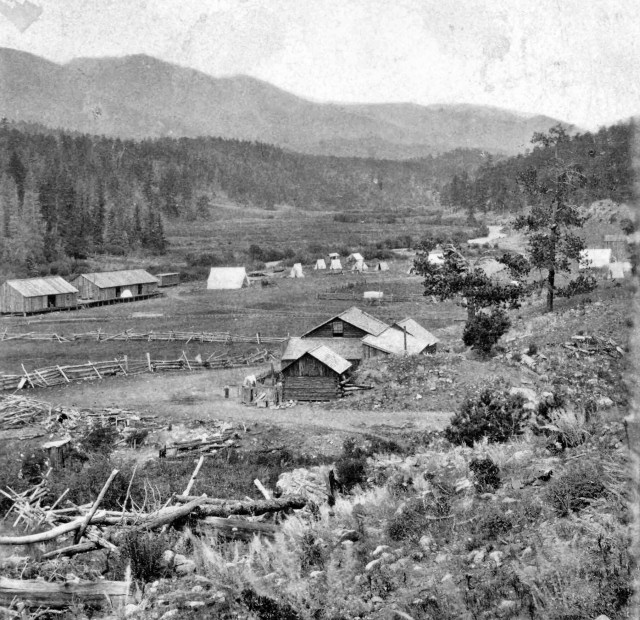 [/center:pn3p8th1] [center:pn3p8th1]3266. Bailey. Circa 1870s. William G. Chamberlain photo. 101 Stereo View. Credit: Ed & Nancy Bathke Collection[/center:pn3p8th1]
Many of these photos are from the 1870s and 1880s and several were taken by professional photographers as stereograms.
The new photos can be found in the following Photo Gallery subjects:
Bailey 2 Circa 1870s
Buckskin Gulch Circa 1880s
Criterion Mine Circa 1880s
Hayman Circa 1921
Horseshoe Circa 1870s
Lake George School Circa 1920s
Montgomery Circa 1870s.and 1880s
Mosquito Gulch Circa 1880s
Mount Lincoln Circa 1870s.and 1880s
Nichols Family Circa 1930s and 1960s
Placer Mines Circa 1880s
South Platte River Circa 1880s
Sovereign Mine Circa 1880s
Van Dyke Family Circa early 1900s, 1940s - 1960s
Finally, just a reminder. The Park County Local History Archives is a non-profit organization completely supported by volunteers and donations. Your support would be greatly appreciated.
Enjoy,
Jim.
http://www.parkcoarchives.org
I have added another 30 historic photos to the Park County Local History Archives website, http://www.parkcoarchives.org
[center:pn3p8th1]
Many of these photos are from the 1870s and 1880s and several were taken by professional photographers as stereograms.
The new photos can be found in the following Photo Gallery subjects:
Bailey 2 Circa 1870s
Buckskin Gulch Circa 1880s
Criterion Mine Circa 1880s
Hayman Circa 1921
Horseshoe Circa 1870s
Lake George School Circa 1920s
Montgomery Circa 1870s.and 1880s
Mosquito Gulch Circa 1880s
Mount Lincoln Circa 1870s.and 1880s
Nichols Family Circa 1930s and 1960s
Placer Mines Circa 1880s
South Platte River Circa 1880s
Sovereign Mine Circa 1880s
Van Dyke Family Circa early 1900s, 1940s - 1960s
Finally, just a reminder. The Park County Local History Archives is a non-profit organization completely supported by volunteers and donations. Your support would be greatly appreciated.
Enjoy,
Jim.
http://www.parkcoarchives.org
Please Log in or Create an account to join the conversation.
- BadgerKustoms
-

- Mountain Advisor
-

Less
More
- Posts: 237
- Thank you received: 0
02 Dec 2011 19:14 #2
by BadgerKustoms
Replied by BadgerKustoms on topic Park County Local History Archives - Update December 2011
I've been wandering through the Park County site for a couple hours now, very awesome! :thumbsup:
Thank you.
Badger
Thank you.
Badger
Please Log in or Create an account to join the conversation.
- TillerBee
-

- Happy Camper
-

Less
More
- Posts: 48
- Thank you received: 0
03 Dec 2011 06:03 #3
by TillerBee
Replied by TillerBee on topic Park County Local History Archives - Update December 2011
I too spend quite a while looking at the website and the GREAT old pictures. Thank you Sapp for adding the pictures and announcing them here.
Are you scanning the old photographs yourself to add them to the binary archive? I notice some of the pictures are low resolution and rather small. Or are you all having a professional archiver scan the photos? Just curious.
Are you scanning the old photographs yourself to add them to the binary archive? I notice some of the pictures are low resolution and rather small. Or are you all having a professional archiver scan the photos? Just curious.
Please Log in or Create an account to join the conversation.
- Sapp
-
Topic Author
- Leaf Peeper
-
Less
More
- Posts: 34
- Thank you received: 0
03 Dec 2011 06:55 #4
by Sapp
Replied by Sapp on topic Park County Local History Archives - Update December 2011
As you might imagine, getting the old photos on-line is a monumental task and the process has changed over time. I only started volunteering a couple years ago. Currently, the images are scanned by our archivist at 600dpi in TIF format. They are quite large as you might imagine. They are sent to me and I reduce them to 640 pixels wide and do what I can to improve the quality. (Many are extremely poor quality when I receive them.) In the early years, no effort was made to improve the quality and techniques used in the size reduction process lost a good deal of the resolution. So, you are correct in that some images are better than others.
One of the advantages I have in this process is access to the full resolution images. The detail in the original images taken by professional photographers with a large format view camera is amazing to say the least. Unfortunately, putting full resolution images on-line is not something we want to do. However, for those doing research, the full resolution images are available for purchase at a very modest fee.
You may also be interested in the how we obtained all these images. They are all donated. The originals are scanned and returned to the donor. The donor provides a "deed" allowing us to use the photos for public use. Without these generous contributions, these historical records would not be available to everyone to enjoy. We are truly indebted to literally hundreds of donors who recognize the value of historical preservation and appreciate the need for public use.
Jim
Please Log in or Create an account to join the conversation.
- TillerBee
-
- Happy Camper
-
Less
More
- Posts: 48
- Thank you received: 0
03 Dec 2011 07:18 #5
by TillerBee
Replied by TillerBee on topic Park County Local History Archives - Update December 2011
Thanks for you quick reply Sapp. I can image the amount of work involved in first obtaining the old images and then creating binary copies. Thank you for taking the time to do all this as well as the other volunteers. The pictures of days gone by are so fascinating! I tried to decide where the original store was here in Shaffers Crossing but couldn't. I guess I'd have to print one of the pictures and go stand in todays Shaffers Crossing to determine where the building was.
I noticed that the maps were lists and not links (for the most part). Is this because they are not digitized?
I worked with the BLM for a while in the 90's. One of the people there got me a copy of the original patent for my land and an old map showing the original Rt. 285. It was sooo interesting. I often look for the old road beds in our area when we hike and wonder about the people who used them way back.
Please Log in or Create an account to join the conversation.
- Sapp
-
Topic Author
- Leaf Peeper
-
Less
More
- Posts: 34
- Thank you received: 0
03 Dec 2011 08:57 #6
by Sapp
I just picked up a copy of "The Elk Creek Chronicles - Shaffer's Crossing to Pine Grove" by David Nelson. It is an interesting book but I do not think it locates exactly where the Shaffer's Store was. However, the Hiwan Homestead Museum in Evergreen has over 7000 photos in their archives, perhaps they can help.
Our map collection is too large to digitize efficiently. I did the "South Park - 1875" map as a demonstration, but it was tedious to say the least. I could be done but we would have to hire a professional to scan in the maps and develop a process to search and retrieve them on-line. Of course, funding is an issue that only a grant could satisfy (or a generous benefactor). Perhaps, a project for the coming years. In the mean time, the hardcopy maps are available at our "office" (I use the term loosely) at the Bailey Library. We are using this small space until the new library in Fairplay is completed. Then, we will have the space we need to adequately store our materials. And, have resources available for public research.
Re: Old roads. You sound like my better half. She is always commenting "That's where the old road went." I have hard time figuring out where today's roads go, much less roads of a 100 years ago.
Jim
Replied by Sapp on topic Park County Local History Archives - Update December 2011
TillerBee wrote: Thanks for you quick reply Sapp. I can image the amount of work involved in first obtaining the old images and then creating binary copies. Thank you for taking the time to do all this as well as the other volunteers. The pictures of days gone by are so fascinating! I tried to decide where the original store was here in Shaffers Crossing but couldn't. I guess I'd have to print one of the pictures and go stand in todays Shaffers Crossing to determine where the building was.
I noticed that the maps were lists and not links (for the most part). Is this because they are not digitized?
I worked with the BLM for a while in the 90's. One of the people there got me a copy of the original patent for my land and an old map showing the original Rt. 285. It was sooo interesting. I often look for the old road beds in our area when we hike and wonder about the people who used them way back. I often look for the old road beds in our area when we hike and wonder about the people who used them way back.
I just picked up a copy of "The Elk Creek Chronicles - Shaffer's Crossing to Pine Grove" by David Nelson. It is an interesting book but I do not think it locates exactly where the Shaffer's Store was. However, the Hiwan Homestead Museum in Evergreen has over 7000 photos in their archives, perhaps they can help.
Our map collection is too large to digitize efficiently. I did the "South Park - 1875" map as a demonstration, but it was tedious to say the least. I could be done but we would have to hire a professional to scan in the maps and develop a process to search and retrieve them on-line. Of course, funding is an issue that only a grant could satisfy (or a generous benefactor). Perhaps, a project for the coming years. In the mean time, the hardcopy maps are available at our "office" (I use the term loosely) at the Bailey Library. We are using this small space until the new library in Fairplay is completed. Then, we will have the space we need to adequately store our materials. And, have resources available for public research.
Re: Old roads. You sound like my better half. She is always commenting "That's where the old road went." I have hard time figuring out where today's roads go, much less roads of a 100 years ago.
Jim
Please Log in or Create an account to join the conversation.
Time to create page: 0.136 seconds
sponsors


