The significant wildland fire potential forecasts included in this outlook represent the cumulative forecasts of the ten Geographic Area Predictive Services units and the National Predictive Services unit. Fire activity continued to increase in April, mostly across the Southwest Area and the plains of Rocky Mountain Area, but slowly decreased in the Southern Area. Year-to-date acres burned for the US is approximately 70% above the 10-year average, with nearly 70% of the acres burned coming from Southern Area, which is not unusual through April.
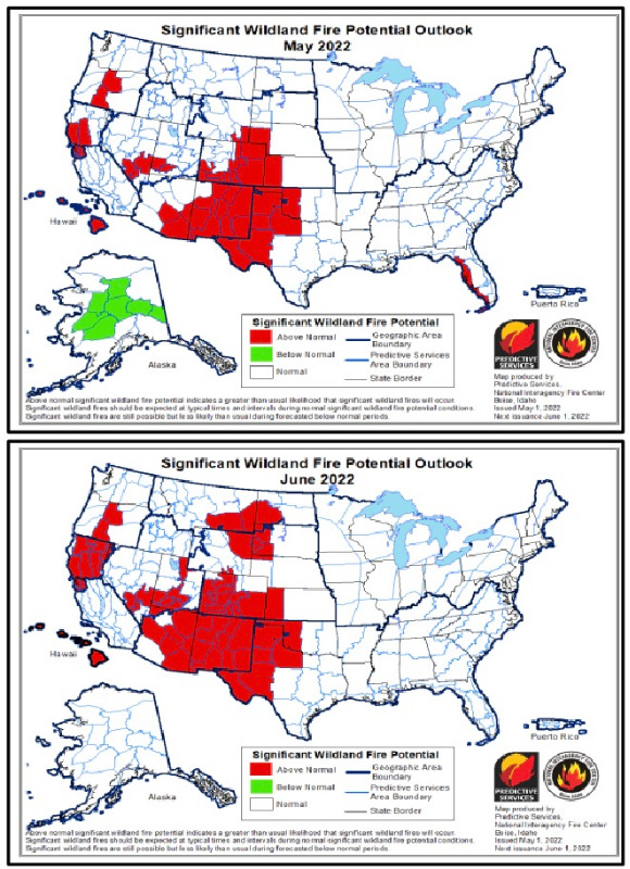
Rocky Mountain: Above normal significant wildland fire potential is expected to continue across portions of the Rocky Mountain Area from May through August due to the persistence and expansion of above normal temperatures and below normal precipitation during the outlook period. In conjunction with long- term precipitation deficits and ongoing drought, the warmer and drier pattern will continue to promote receptive fuels as well as rapid fire spread potential during wind events. There could also be a period in late June with more than average lightning ignitions preceding the timely onset of a robust monsoon.
A weak La Niña climate signal continued to influence precipitation patterns across the Rocky Mountain Area in March and April but overall, temperatures were slightly cooler than climatology. Episodes of strong downslope wind events off the Laramie Mountains and Front Range eastward across the High Plains were much more frequent and intense. The northerly track of storm systems left the area in a drier regime with multi-day periods of single digit to teens afternoon relative humidity and high wind events bringing gusts over 50 mph. The National Weather Service offices in Wyoming and Colorado reported record numbers of High Wind Warnings. In April, Colorado observed 19 consecutive days with Red Flag Warnings, which is unprecedented.
Expectations are that seasonal temperatures, residual snow cover, and occasional wetting rains will continue to keep fire danger and significant fire potential low in most areas west of the Divide through the first half of May. May is normally the wettest month of the year east of the Continental Divide along and adjacent to the Front Range Foothills and onto the High Plains. During the first two or three weeks of May that is anticipated to bring some beneficial rain and encourage fine fuel growth. Thereafter, in late May and into June, lower elevation sites across southern Colorado and most areas east of the Divide will resume drier-than-normal conditions with fine fuels expected to display more of a mosaic in green-up conditions. Some areas will exhibit patchy, new growth while others will see delayed growth interspersed with denser and drier fuels. Given the previously dry conditions, any new grass growth will likely be short, patchy, and quick to cure with the above normal temperatures expected across the area during late May and June. With the warmer temperatures and the persistence of receptive fuel beds, lightning ignitions will likely increase over the next two months, especially over southern and western Colorado during late June and July preceding the early arrival of monsoon thunderstorms.