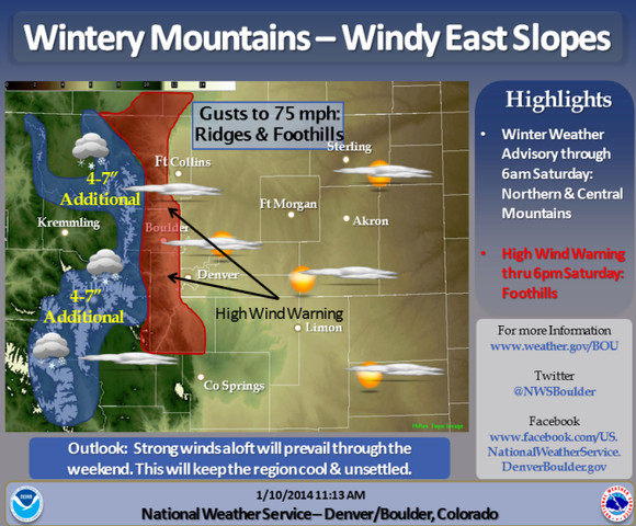
For today and tonight:
Strong winds will continue over the mountains and Front Range
foothills through tonight. Gusts in the 40 to 75 mph range will
be common in these areas, producing near blizzard conditions in
higher mountain areas. Snow will continue to fall in the higher
mountains, with additional accumulations of 3 to 7 inches by
Saturday morning. At lower elevations winds will gust as high as
60 mph near the foothills and along the state line south of
Cheyenne. Even stronger winds up to 80 will be possible later
tonight.
For Saturday through Thursday:
Strong winds will continue in and near the foothills Saturday ahead
of the next weather system currently over the Pacific northwest.
Dry, mild and windy conditions will prevail elsewhere. Snow will
redevelop in the mountains late Saturday night and continue
through the day Sunday as the weather system moves across the
state. The snow could be heavy at times, especially north of
Interstate 70, with snowpacked roads expected. In addition, gusty
winds will produce blowing snow over higher mountain passes with
reduced visibility. Across the plains dry and breezy conditions
will prevail. The mountain snowfall will decrease Sunday night as
the system moves away from the state. High pressure will build
over the region Monday through Wednesday, with dry and warmer
conditions expected. A cold front will bring cooler temperature
to the region on Thursday, with dry conditions continuing.
Spotter activation will not be needed, however spotter reports
of heavy snow and strong winds will be appreciated.
http://www.crh.noaa.gov/bou/