- Posts: 9766
- Thank you received: 221
- Forum
- Life Up the Hill
- Scanner & Emergency Info, Weather Forecasts
- Flash Flood Watch for Jeffco, Park County Through June 12 at noon
Flash Flood Watch for Jeffco, Park County Through June 12 at noon
- MountainTownAlerts
-
 Topic Author
- Mountain Legend
-

Less
More
10 Jun 2015 11:57 #1
by MountainTownAlerts
Posted 14 minutes ago
Heavy rain possible over northeastern Colorado plains and foothills Thursday through Friday morning.
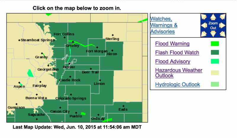
Near Record moisture levels in the atmosphere combined with upslope flow after a cold front Thursday morning will bring widespread showers and with embedded thunderstorms to the area Thursday through Friday morning. Very wet thunderstorms today will help saturate the already wet soils around the area, inhibiting rain from soaking in and increasing flash flood threats. Rock and mudslides in the foothills may become an issue as well as the ground fills with water. Rain will transition from storms to more of a widespread steady rain Friday.
Flash Flood Watch in effect from Thursday morning through Friday morning.
The National Weather Service in Denver has issued a Flash Flood Watch for portions of central Colorado, East Central Colorado, North Central Colorado and northeast Colorado, including the following areas, in central Colorado, Jefferson and West Douglas Counties above 6000 feet/gilpin/clear Creek/northeast Park counties below 9000 feet. In East Central Colorado, North and Northeast Elbert County below 6000 feet/north Lincoln County and Southeast Elbert County below 6000 feet/south Lincoln County. In North Central Colorado, Larimer County below 6000 feet/northwest Weld County and Larimer and Boulder counties between 6000 and 9000 feet. In Northeast Colorado, Boulder and Jefferson counties below 6000 feet/west Broomfield county, Central and East Adams and Arapahoe counties, Central and South Weld County, Elbert/central and East Douglas Counties above 6000 feet, Morgan County, North Douglas County below 6000 feet/denver/west Adams and Arapahoe counties/east Broomfield County, northeast Weld County and Washington County.
From Thursday morning through Friday morning.
Showers and thunderstorms in moist upslope flow are expected through the day and evening. Rain will transition to more widespread coverage Friday morning. Overall 1 to 2 inches of rain are expected over the area, however a stronger storm could produce 1 to 2 inches of rain over an area that may produce flash flooding.
Streams and rivers may rise rapidly as water runoff will occur quickly. Paved surfaces and roads may fill up quickly making travel difficult. Rock/mudslides may occur in the foothills that may affect or block roads.
Recommended actions
A Flash Flood Watch means that conditions may develop that lead to flash flooding. Flash Flooding is a very dangerous situation. You should monitor later forecasts and be prepared to take action should Flash Flood Warnings be issued.
1117 am MDT Wed Jun 10 2015
The National Weather Service in Denver has issued a
* Flood Advisory for
the South Platte river at South Platte.
* Until Friday afternoon.
* Flood stage is 7.0 feet.
* Forecast... the river will rise to near 6.3 feet Thursday morning.
* Impact... at 6.0 feet... the river begins to flow into low lying areas
upstream near Deckers.
www.wunderground.com/US/CO/039.html
Posted 14 minutes ago
Heavy rain possible over northeastern Colorado plains and foothills Thursday through Friday morning.
Near Record moisture levels in the atmosphere combined with upslope flow after a cold front Thursday morning will bring widespread showers and with embedded thunderstorms to the area Thursday through Friday morning. Very wet thunderstorms today will help saturate the already wet soils around the area, inhibiting rain from soaking in and increasing flash flood threats. Rock and mudslides in the foothills may become an issue as well as the ground fills with water. Rain will transition from storms to more of a widespread steady rain Friday.
Flash Flood Watch in effect from Thursday morning through Friday morning.
The National Weather Service in Denver has issued a Flash Flood Watch for portions of central Colorado, East Central Colorado, North Central Colorado and northeast Colorado, including the following areas, in central Colorado, Jefferson and West Douglas Counties above 6000 feet/gilpin/clear Creek/northeast Park counties below 9000 feet. In East Central Colorado, North and Northeast Elbert County below 6000 feet/north Lincoln County and Southeast Elbert County below 6000 feet/south Lincoln County. In North Central Colorado, Larimer County below 6000 feet/northwest Weld County and Larimer and Boulder counties between 6000 and 9000 feet. In Northeast Colorado, Boulder and Jefferson counties below 6000 feet/west Broomfield county, Central and East Adams and Arapahoe counties, Central and South Weld County, Elbert/central and East Douglas Counties above 6000 feet, Morgan County, North Douglas County below 6000 feet/denver/west Adams and Arapahoe counties/east Broomfield County, northeast Weld County and Washington County.
From Thursday morning through Friday morning.
Showers and thunderstorms in moist upslope flow are expected through the day and evening. Rain will transition to more widespread coverage Friday morning. Overall 1 to 2 inches of rain are expected over the area, however a stronger storm could produce 1 to 2 inches of rain over an area that may produce flash flooding.
Streams and rivers may rise rapidly as water runoff will occur quickly. Paved surfaces and roads may fill up quickly making travel difficult. Rock/mudslides may occur in the foothills that may affect or block roads.
Recommended actions
A Flash Flood Watch means that conditions may develop that lead to flash flooding. Flash Flooding is a very dangerous situation. You should monitor later forecasts and be prepared to take action should Flash Flood Warnings be issued.
1117 am MDT Wed Jun 10 2015
The National Weather Service in Denver has issued a
* Flood Advisory for
the South Platte river at South Platte.
* Until Friday afternoon.
* Flood stage is 7.0 feet.
* Forecast... the river will rise to near 6.3 feet Thursday morning.
* Impact... at 6.0 feet... the river begins to flow into low lying areas
upstream near Deckers.
www.wunderground.com/US/CO/039.html
Please Log in or Create an account to join the conversation.
- MountainTownAlerts
-
Topic Author
- Mountain Legend
-
Less
More
- Posts: 9766
- Thank you received: 221
10 Jun 2015 21:59 #2
by MountainTownAlerts
Replied by MountainTownAlerts on topic Flash Flood Watch for Jeffco, Park County Through June 12 at noon
From the Park County Sheriff's Office:
June 11th 2015-FLASH FLOOD WATCH IN EFFECT.
Near Record moisture levels in the atmosphere combined with upslope flow after a cold front will bring widespread showers and thunderstorms to our area Thursday and Friday.
The National Weather Service in Denver has issued a Flash Flood Watch for portions of central Colorado, including Park County.
Streams and rivers may rise rapidly as water runoff can occur very quickly.
A Flash flood watch means that conditions could develop that lead to a Flash Flood. Please monitor local news channels for forecasts.
Park County Sheriff's Office
Please Log in or Create an account to join the conversation.
- MountainTownAlerts
-
Topic Author
- Mountain Legend
-
Less
More
- Posts: 9766
- Thank you received: 221
11 Jun 2015 13:47 - 11 Jun 2015 14:00 #3
by MountainTownAlerts
Replied by MountainTownAlerts on topic Flash Flood Watch for Jeffco, Park County Through June 12 at noon
Jeffco Sheriff @jeffcosheriffco 17 minutes ago
ALERT: Potential for a HUGE amount of rain starting today for the next 30 hours. Stay alert & prepare #Jeffco #cowx ow.ly/Oc7VN
Jeffco Sheriff @jeffcosheriffco 23 minutes ago
THIS JUST IN: Our Emergency Management and Preparedness experts are very concerned about the potential for... fb.me/xyv07cIL
THIS JUST IN: Our Emergency Management and Preparedness experts are very concerned about the potential for flooding in the county during the next 30 hours. The Jeffco Sheriff’s Office is taking steps to prepare for the weather and we are asking for residents to do the same.
Starting this afternoon and lasting through noon on Saturday, there is the potential for parts of Jefferson County to receive a tremendous amount of rain. That’s why we have issued a CodeRed alert for flash flooding for the South Platte River in Jeffco through Saturday.
According to the National Weather Service, significant increases in stream and river levels are expected, and this afternoon there is a flash flood threat from thunderstorms with localized areas of an inch of rain in less than a half hour possible.
By tonight, widespread moderate rain is expected to begin along the foothills and urban corridor. In the event of a flood, people in the area should avoid moving water and seek higher ground.
Please heed weather warnings and monitor conditions, as they can change rapidly.
Do not drive through high water.
To sign up for our CodeRed alerts, please visit our website: tinyurl.com/FlashFloodNotification
Please share this information with anyone who might be affected. Please stay tuned to your local news, the National Weather Service and our social media sites for updates. #cowx
Last edit: 11 Jun 2015 14:00 by MountainTownAlerts. Reason: added info
Please Log in or Create an account to join the conversation.
- Forum
- Life Up the Hill
- Scanner & Emergency Info, Weather Forecasts
- Flash Flood Watch for Jeffco, Park County Through June 12 at noon
Time to create page: 0.176 seconds
sponsors


