Please be advised Platte Canyon Fire Protection District is in a Red Flag Warning from 03/03/17 - 03/04/2017. This also means we are in BURN BAN until further notice.
URGENT - FIRE WEATHER MESSAGE
National Weather Service Denver/Boulder CO
401 AM MST Sat Mar 4 2017
...
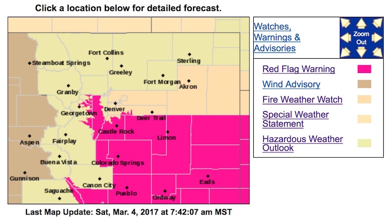
HIGH FIRE DANGER ON THE PALMER DIVIDE...SOUTHERN FRONT RANGE
FOOTHILLS AND PARTS OF THE NORTHEAST PLAINS THIS WEEKEND...
.Gusty southwest winds, very low relative humidity, well above
average temperatures and dry fuels may result dangerous rangeland
fire behavior including large fire spreads should fires get
started. These critical fire weather conditions are most likely
to appear during the afternoon hours today and again on Sunday.
Open burning is prohibited on Red Flag Warning days. Residents
across all of northeast Colorado should remain alert as these
potentially dangerous conditions could expand in area with little
notice.
COZ216-241-246-247-041915-
/O.CON.KBOU.FW.W.0007.170304T1900Z-170305T0100Z/
/O.CON.KBOU.FW.A.0006.170305T1900Z-170306T0100Z/
Jefferson and West Douglas Counties Above 6000 Feet/Gilpin/Clear
Creek/Northeast Park Counties Below 9000 Feet-
Elbert/Central and East Douglas Counties Above 6000 Feet-
North and Northeast Elbert County Below 6000 Feet/North Lincoln
County-
Southeast Elbert County Below 6000 Feet/South Lincoln County-
401 AM MST Sat Mar 4 2017
...
RED FLAG WARNING IN EFFECT FROM NOON TO 6 PM MST TODAY FOR
GUSTY WINDS AND VERY LOW RELATIVE HUMIDITY...FOR THE PALMER
DIVIDE AREA...FIRE WEATHER ZONES 241...246...AND 247...AND
SOUTHERN FRONT RANGE FOOTHILLS...FIRE WEATHER ZONE 216.
...
A FIRE WEATHER WATCH REMAINS IN EFFECT FOR SUNDAY AFTERNOON
FOR STRONG GUSTY WINDS AND LOW RELATIVE HUMIDITY...
* Affected Area...Fire Weather Zones 216...241...246 and 247.
* Timing...Critical fire weather conditions are expected this
afternoon, and again Sunday afternoon. Conditions should
improve with nightfall.
* Winds...Southwest 15 to 25 mph with gusts to around 35 mph.
Strongest winds are expected at lower elevations Sunday afternoon.
* Relative Humidity...as low as 7 percent.
* Impacts...Fire will quickly spread through the dry vegetation
with the warm, dry and gusty winds expected this weekend.
PRECAUTIONARY/PREPAREDNESS ACTIONS...
A Red Flag Warning means that critical fire weather conditions
are either occurring now....or will shortly. A combination of
gusty winds...very low relative humidity...and warm temperatures
can contribute to extreme fire behavior.
A Fire Weather Watch means that critical fire weather conditions
are forecast to occur. Continue to listen for the later forecasts
and possible Red Flag Warnings from the National Weather Service.