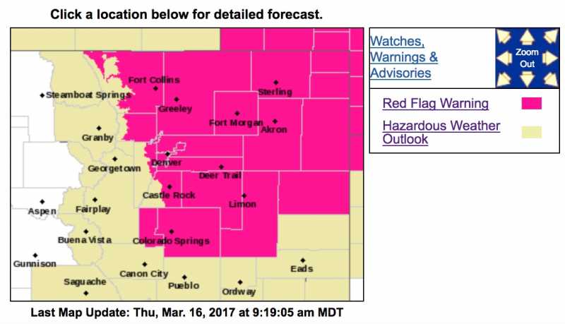
Red Flag Warning
URGENT - FIRE WEATHER MESSAGE
National Weather Service Denver/Boulder CO
728 AM MDT Thu Mar 16 2017
...Very High Fire Danger Across Northeast Colorado Today...
.Increasing west to northwest winds coupled with low relative
humidities and dry fuels will produce potentially dangerous fire
behavior conditions across the northeast Colorado plains later
today.
COZ238>251-162130-
/O.CON.KBOU.FW.W.0015.170316T1700Z-170317T0100Z/
Larimer County Below 6000 Feet/Northwest Weld County-
Boulder And Jefferson Counties Below 6000 Feet/West Broomfield
County-
North Douglas County Below 6000 Feet/Denver/West Adams and
Arapahoe Counties/East Broomfield County-
Elbert/Central and East Douglas Counties Above 6000 Feet-
Northeast Weld County-Central and South Weld County-Morgan County-
Central and East Adams and Arapahoe Counties-
North and Northeast Elbert County Below 6000 Feet/North Lincoln
County-
Southeast Elbert County Below 6000 Feet/South Lincoln County-
Logan County-Washington County-Sedgwick County-Phillips County-
728 AM MDT Thu Mar 16 2017
...
RED FLAG WARNING REMAINS IN EFFECT FROM 11 AM THIS MORNING TO
7 PM MDT THIS EVENING FOR WIND AND LOW RELATIVE HUMIDITY FOR THE
NORTHEAST COLORADO PLAINS...
* Affected Area...Fire Weather Zones 238...239...240...241...
242...243...244...245...246...247...248...249...250 and 251.
* Timing...Gusty winds and low relative humidities are expected
develop late this morning and continue into early this evening.
* Winds...West 15 to 25 mph with gusts up to 35 mph.
* Relative Humidity...as low as 9 percent.
* Impacts...Conditions will be favorable for the ignition and
rapid growth of wildfires. Wind-driven fires will be difficult
to contain.
PRECAUTIONARY/PREPAREDNESS ACTIONS...
A Red Flag Warning means that critical fire weather conditions
are either occurring now....or will shortly. The combination of
strong winds...low relative humidity...and warm temperatures can
contribute to extreme fire behavior. Residents should not perform
any outdoor burning today because of the potential for fires to
spread uncontrollably.
Hazardous Weather Outlook
HAZARDOUS WEATHER OUTLOOK
NATIONAL WEATHER SERVICE DENVER/BOULDER CO
521 AM MDT Thu Mar 16 2017
COZ030>051-171130-
JACKSON COUNTY BELOW 9000 FEET-
WEST JACKSON AND WEST GRAND COUNTIES ABOVE 9000 FEET-
GRAND AND
SUMMIT COUNTIES BELOW 9000 FEET-
SOUTH AND EAST JACKSON/LARIMER/NORTH AND NORTHEAST GRAND/
NORTHWEST BOULDER COUNTIES ABOVE 9000 FEET-
SOUTH AND SOUTHEAST GRAND/WEST CENTRAL AND SOUTHWEST BOULDER/
GILPIN/CLEAR CREEK/SUMMIT/NORTH AND WEST PARK COUNTIES ABOVE
9000 FEET-LARIMER AND BOULDER COUNTIES BETWEEN 6000 AND 9000 FEET-
JEFFERSON AND WEST DOUGLAS COUNTIES ABOVE 6000 FEET/GILPIN/CLEAR
CREEK/NORTHEAST PARK COUNTIES BELOW 9000 FEET-
CENTRAL AND SOUTHEAST PARK COUNTY-
LARIMER COUNTY BELOW 6000 FEET/NORTHWEST WELD COUNTY-
BOULDER AND JEFFERSON COUNTIES BELOW 6000 FEET/WEST BROOMFIELD
COUNTY-
NORTH DOUGLAS COUNTY BELOW 6000 FEET/DENVER/WEST ADAMS AND
ARAPAHOE COUNTIES/EAST BROOMFIELD COUNTY-
ELBERT/CENTRAL AND EAST DOUGLAS COUNTIES ABOVE 6000 FEET-
NORTHEAST WELD COUNTY-CENTRAL AND SOUTH WELD COUNTY-MORGAN COUNTY-
CENTRAL AND EAST ADAMS AND ARAPAHOE COUNTIES-
NORTH AND NORTHEAST ELBERT COUNTY BELOW 6000 FEET/NORTH LINCOLN
COUNTY-
SOUTHEAST ELBERT COUNTY BELOW 6000 FEET/SOUTH LINCOLN COUNTY-
LOGAN COUNTY-WASHINGTON COUNTY-SEDGWICK COUNTY-PHILLIPS COUNTY-
521 AM MDT Thu Mar 16 2017
...RED FLAG WARNING IN EFFECT FOR THE NORTHEAST PLAINS THIS
AFTERNOON...
...
FIRE WEATHER WATCH IN EFFECT FOR THE FRONT RANGE FOOTHILLS THIS
AFTERNOON...
THIS HAZARDOUS WEATHER OUTLOOK IS FOR NORTHEAST AND NORTH CENTRAL
COLORADO.
.DAY ONE...TODAY AND TONIGHT
Temperatures will continue much warmer than normal today as an
upper level ridge of high pressure remains over Colorado. Gusty
west to northwest winds are expected this afternoon with gusts of
25 to 35 mph during the afternoon. The combination of warm
temperatures and gusty winds will raise the fire danger across
northeast Colorado to very high levels. A Red Flag Warning has
been issued for the potential of extreme fire behavior if fires
get started. No other hazardous weather is expected today, but
residents should be especially careful if handling burning
materials.
.DAYS TWO THROUGH SEVEN...FRIDAY THROUGH WEDNESDAY
Warm and dry conditions will prevail through the weekend with a
cool down early next week. The fire danger is expected to be
elevated Saturday and Sunday from the foothills across the plains.
Windy conditions will develop, especially on Sunday.
.SPOTTER INFORMATION STATEMENT...
Spotter activation will not be needed today or tonight.