Don't forget to check back to see updates to Chief Meteorologist Steve Hamilton's mountain weather forecasts for your town as the weather moves in (and ask him any questions you have)! Go to our Expert Local Weather Forecasts Page here:
mymountaintown.com/expert-local-weather
and have fun playing around with the custom interactive weather radar map - you can toggle on/off temps, wind speeds, storm tracks, severe weather alerts, and more!
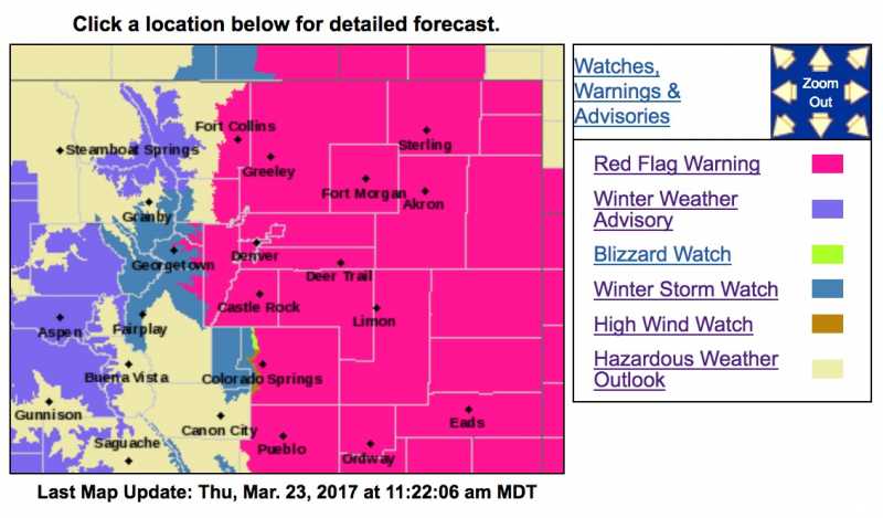
Red Flag Warning: Today Until 6:00 p.m.
Winter Storm Watch: Thursday Evening Through Friday Morning
Finally we get a chance to talk about snow and rain for the foothills. Most locations are under a Winter Storm Watch for accumulating snow Thursday night through Friday morning. A fast-moving low pressure area will cause upslope conditions as it moves through eastern Colorado, with the potential for a decent amount of snow: Possibly up to 10 inches for some areas. Plan on slick roadways and winter driving conditions Thursday night and for the Friday morning commute.
Red Flag Warning
URGENT - FIRE WEATHER MESSAGE
National Weather Service Denver/Boulder CO
858 AM MDT Thu Mar 23 2017
...Red Flag Warning for the Southern Foothills, Palmer Divide and
northeast Plains, including Denver this afternoon...
Conditions will be very warm and dry through this afternoon, with
gusty southerly winds expected. Colder temperatures coupled with
rain and snow will sweep across across much of the region tonight
and Friday. Weld and Larimer counties have been added to the
warning. With higher moisture levels over Phillips and Sedgwick
counties that humidity levels may not get low enough but will keep
the Red Flag Warning going for now.
COZ216-239>242-244>251-232300-
/O.CON.KBOU.FW.W.0018.170323T1800Z-170324T0000Z/
Jefferson and West Douglas Counties Above 6000 Feet/Gilpin/Clear
Creek/Northeast Park Counties Below 9000 Feet-
Boulder And Jefferson Counties Below 6000 Feet/West Broomfield
County-
North Douglas County Below 6000 Feet/Denver/West Adams and
Arapahoe Counties/East Broomfield County-
Elbert/Central and East Douglas Counties Above 6000 Feet-
Northeast Weld County-Morgan County-
Central and East Adams and Arapahoe Counties-
North and Northeast Elbert County Below 6000 Feet/North Lincoln
County-
Southeast Elbert County Below 6000 Feet/South Lincoln County-
Logan County-Washington County-Sedgwick County-Phillips County-
858 AM MDT Thu Mar 23 2017
...
RED FLAG WARNING REMAINS IN EFFECT FROM NOON TODAY TO 6 PM MDT
THIS EVENING FOR WIND AND LOW RELATIVE HUMIDITY FOR MUCH OF
NORTHEAST COLORADO...
* Affected Area...Fire Weather Zones 216...239...240...241...
242...244...245...246...247...248...249...250 and 251.
* Timing...Gusty southerly winds will develop by midday and
continue through this afternoon with the relative humidities
dropping to around 10 percent.
* Winds...Southwest 15 to 25 mph with gusts up to 35 mph.
* Relative Humidity...as low as 9 percent.
* Impacts...Conditions will be favorable for rapid ignition of
dry vegetation, fire growth and spread. Any outdoor burning is
strongly discouraged, and in some areas, illegal. Check with
local law enforcement.
PRECAUTIONARY/PREPAREDNESS ACTIONS...
A Red Flag Warning means that critical fire weather conditions
are either occurring now....or will shortly. A combination of
strong winds...low relative humidity...and warm temperatures can
contribute to extreme fire behavior.
Winter Storm Watch
URGENT - WINTER WEATHER MESSAGE
National Weather Service Denver/Boulder CO
500 AM MDT Thu Mar 23 2017
...
Blizzard conditions possible late tonight through
Friday morning across the Palmer Divide towards the Limon
area...
A spring storm will bring much needed precipitation to northeast
and north central Colorado. Precipitation is expected to develop
across the forecast area tonight and then intensify late tonight
through Friday morning as the storm system strengthens over
southeast Colorado. Moderate to heavy snowfall will be possible
over the mountains, foothills and Palmer Ridge late tonight into
Friday morning, heaviest along and south of of the I-70 corridor.
Very strong northerly winds will develop late tonight and
continue through midday Friday across the plains with blizzard
conditions possible from the Palmer Divide towards Limon with zero
visiblities at times.
COZ034-036-231900-
/O.EXT.KBOU.WS.A.0007.170324T0600Z-170324T1800Z/
South and Southeast Grand/
West Central and Southwest Boulder/
Gilpin/Clear Creek/Summit/North and West Park Counties Above
9000 Feet-
Jefferson and West Douglas Counties Above 6000 Feet/Gilpin/Clear
Creek/Northeast Park Counties Below 9000 Feet-
500 AM MDT Thu Mar 23 2017
...
WINTER STORM WATCH NOW IN EFFECT FROM LATE TONIGHT THROUGH
FRIDAY MORNING...
* TIMING...Snow will increase in intensity over the mountains and
southern foothills after midnight and continue through Friday
morning. The heaviest snowfall is likely from late tonight
through Friday morning.
*
SNOW ACCUMULATIONS...7 to 14 inches over the high mountains and
southern foothills. Snowfall rates up to two inches per hour
will be possible in the mountains and southern foothills early
Friday morning.
* WIND/VISIBILITY...Northerly winds from 15 to 25 mph with gusts
to 35 mph are expected over the southern Foothills late tonight
through Friday morning. Speeds will be much lighter in the
mountains with gusts up to 20 mph at times. Visibilities could
be under one quarter of a mile in the windiest areas.
* IMPACTS...Heavy snow, strong winds and poor visibilities will
create hazardous winter driving conditions. Roads will be icy
and snow packed.
PRECAUTIONARY/PREPAREDNESS ACTIONS...
A Winter Storm Watch means there is a potential for significant
snow...sleet...or ice accumulations that may impact travel.
Continue to monitor the latest forecasts.