- Posts: 9766
- Thank you received: 221
- Forum
- Life Up the Hill
- Scanner & Emergency Info, Weather Forecasts
- Winter Storm Watch 5.16.17-5.18.17
Winter Storm Watch 5.16.17-5.18.17
- MountainTownAlerts
-
 Topic Author
- Mountain Legend
-

Less
More
16 May 2017 17:33 - 16 May 2017 17:51 #1
by MountainTownAlerts
Winter Storm Watch 5.16.17-5.18.17 was created by MountainTownAlerts
Check back for updates and watch the storm develop on our custom radar map on Chief Meteorologist Steve Hamilton's
My Mountain Town Weather Page.
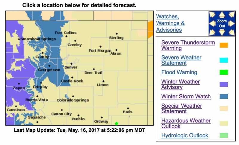
Winter Storm Watch
URGENT - WINTER WEATHER MESSAGE
National Weather Service Denver/Boulder CO
427 PM MDT Tue May 16 2017
...HEAVY SNOW EXPECTED FOR THE MOUNTAINS AND FOOTHILLS WEDNESDAY NIGHT THROUGH FRIDAY...
.A strong spring storm will drop south across the Great Basin Wednesday night and Thursday. It then moves slowly east across Colorado Thursday night and Friday. Significant snow is expected with this storm if it continues on the current forecasted track. Snowfall amounts of 1 to 3 feet will be possible for the foothills and east slopes of the mountains. If this heavy snow occurs, breaking tree limbs and snow accumulation on power lines will likely cause power lines to break. Numerous power outages will be possible if the heavy snow occurs.
This storm is expected to bring rain and possibly snow to the Urban Corridor including the Denver Metro area. The coldest air and best chance for snow is expected to be Thursday night and Friday for the Denver area. Significant snow for the Denver area can`t be ruled out at this time.
COZ033-034-171200-
/O.NEW.KBOU.WS.A.0012.170518T0000Z-170520T0000Z/
South and East Jackson/Larimer/North and Northeast Grand/Northwest Boulder Counties Above 9000 Feet-
South and Southeast Grand/West Central and Southwest Boulder/
Gilpin/Clear Creek/Summit/North and West Park Counties Above 9000 Feet-
Including the cities of Cameron Pass, Laramie and Medicine Bow Mountains, Rabbit Ears Range,
Rocky Mountain National Park, Willow Creek Pass, Berthoud Pass, Breckenridge, East Slopes Mosquito Range, East Slopes Southern Gore Range, Eisenhower Tunnel, Indian Peaks, Kenosha Mountains, Mount Evans, Williams Fork Mountains, and Winter Park
427 PM MDT Tue May 16 2017
...WINTER STORM WATCH IN EFFECT FROM WEDNESDAY EVENING THROUGH FRIDAY AFTERNOON...
The National Weather Service in Denver has issued a Winter Storm Watch, which is in effect from Wednesday evening through Friday afternoon.
* TIMING...Snow is expected to begin Wednesday evening and continue through Friday afternoon.
* SNOW ACCUMULATIONS...1 to 2 feet of snow is possible with up to 3 feet on favored east slopes.
* WIND/VISIBILITY...Visibility will fall below a quarter mile in heavy snow.
* IMPACTS...Roads will likely become snow and slush covered. Wet snow may accumulate on leafed out trees, resulting in broken tree limbs and power outages.
PRECAUTIONARY/PREPAREDNESS ACTIONS...
A Winter Storm Watch means there is a potential for significant snow...sleet...or ice accumulations that may impact travel. Continue to monitor the latest forecasts.
URGENT - WINTER WEATHER MESSAGE
National Weather Service Denver/Boulder CO
427 PM MDT Tue May 16 2017
...HEAVY SNOW EXPECTED FOR THE MOUNTAINS AND FOOTHILLS WEDNESDAY NIGHT THROUGH FRIDAY...
.A strong spring storm will drop south across the Great Basin Wednesday night and Thursday. It then moves slowly east across Colorado Thursday night and Friday. Significant snow is expected with this storm if it continues on the current forecasted track. Snowfall amounts of 1 to 3 feet will be possible for the foothills and east slopes of the mountains. If this heavy snow occurs, breaking tree limbs and snow accumulation on power lines will likely cause power lines to break. Numerous power outages will be possible if the heavy snow occurs.
This storm is expected to bring rain and possibly snow to the Urban Corridor including the Denver Metro area. The coldest air and best chance for snow is expected to be Thursday night and Friday for the Denver area. Significant snow for the Denver area can`t be ruled out at this time.
COZ035-036-171200-
/O.NEW.KBOU.WS.A.0012.170518T0600Z-170520T0000Z/
Larimer and Boulder Counties Between 6000 and 9000 Feet-
Jefferson and West Douglas Counties Above 6000 Feet/Gilpin/Clear
Creek/Northeast Park Counties Below 9000 Feet-
Including the cities of Estes Park, Glendevey, Nederland,
Red Feather Lakes, Bailey, Central City, Evergreen, Georgetown,
Idaho Springs, and Westcreek
427 PM MDT Tue May 16 2017
...WINTER STORM WATCH IN EFFECT FROM LATE WEDNESDAY NIGHT THROUGH FRIDAY AFTERNOON...
The National Weather Service in Denver has issued a Winter Storm Watch, which is in effect from late Wednesday night through Friday afternoon.
* TIMING...Rain is expected to change to snow Wednesday evening as cold air moves into the area. Snow is expected to continue through Friday afternoon before it dissipates.
* SNOW ACCUMULATIONS...1 to 2 feet of snow is possible with up to 3 feet on favored east slopes.
* WIND/VISIBILITY...Visibility will fall below a quarter mile in heavy snow.
* IMPACTS...Roads will likely become snow and slush covered. Wet snow may accumulate on leafed out trees, resulting in broken tree limbs and power outages.
PRECAUTIONARY/PREPAREDNESS ACTIONS...
A Winter Storm Watch means there is a potential for significant snow...sleet...or ice accumulations that may impact travel. Continue to monitor the latest forecasts.
Last edit: 16 May 2017 17:51 by MountainTownAlerts. Reason: added Jeffco, lower Park Co & Clear Creek
Please Log in or Create an account to join the conversation.
- MountainTownAlerts
-
Topic Author
- Mountain Legend
-
Less
More
- Posts: 9766
- Thank you received: 221
17 May 2017 10:11 #2
by MountainTownAlerts
Replied by MountainTownAlerts on topic Winter Storm Watch 5.16.17-5.18.17
Check back for updates, and watch the storm develop on our custom radar map, on Chief Meteorologist Steve Hamilton's
My Mountain Town Weather Page
and find out road conditions on our exclusive and comprehensive
webcam pages
covering Hwy 285 and I-70.
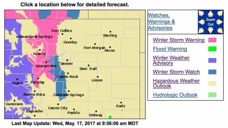
Winter Storm Warning
URGENT - WINTER WEATHER MESSAGE
National Weather Service Denver/Boulder CO
441 AM MDT Wed May 17 2017
...HEAVY SNOW EXPECTED FOR THE MOUNTAINS AND NORTHERN FRONT RANGE FOOTHILLS WEDNESDAY NIGHT THROUGH FRIDAY...
.A strong spring storm will drop south across the Great Basin Wednesday night and Thursday. It then moves slowly east across Colorado Thursday night and Friday. Significant snow is expected with this storm if it continues on the current forecasted track. If the storm track moves further North, then the Southern Front Range Foothills may receive much less snowfall.
This storm is expected to bring rain and possibly snow to the Urban Corridor including the Denver Metro area. The coldest air and best chance for snow is expected to be Thursday night and Friday for the Denver area. Significant snow for the Denver area can`t be ruled out at this time.
COZ033-034-171845-
/O.UPG.KBOU.WS.A.0012.170518T0000Z-170520T0000Z/
/O.NEW.KBOU.WS.W.0011.170518T0000Z-170520T0000Z/
South and East Jackson/Larimer/North and Northeast Grand/
Northwest Boulder Counties Above 9000 Feet-
South and Southeast Grand/West Central and Southwest Boulder/
Gilpin/Clear Creek/Summit/North and West Park Counties Above 9000 Feet-
Including the cities of Cameron Pass,
Laramie and Medicine Bow Mountains, Rabbit Ears Range, Rocky Mountain National Park, Willow Creek Pass, Berthoud Pass, Breckenridge, East Slopes Mosquito Range, East Slopes Southern Gore Range, Eisenhower Tunnel, Indian Peaks, Kenosha Mountains, Mount Evans, Williams Fork Mountains, and Winter Park
441 AM MDT Wed May 17 2017
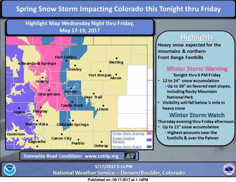
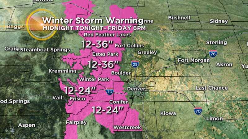
...WINTER STORM WARNING IN EFFECT FROM 6 PM THIS EVENING TO 6 PM MDT FRIDAY...
The National Weather Service in Denver has issued a Winter Storm Warning for heavy snow, which is in effect from 6 PM this evening to 6 PM MDT Friday. The Winter Storm Watch is no longer in effect.
* TIMING...Snow is expected to begin Wednesday evening and continue through Friday afternoon.
* SNOW ACCUMULATIONS...1 to 2 feet of snow expected with up to 3 feet on favored east slopes, including Rocky Mountain National Park.
* WIND/VISIBILITY...Visibility will fall below a quarter mile in heavy snow.
* IMPACTS...Roads will likely become snow and slush covered. Wet snow may accumulate on leafed out trees, resulting in broken tree limbs and power outages.
PRECAUTIONARY/PREPAREDNESS ACTIONS...
A Winter Storm Warning for heavy snow means severe winter weather conditions are expected or occurring. Significant amounts of snow are forecast that will make travel dangerous. Only travel in an emergency. If you must travel...keep an extra flashlight...food...and water in your vehicle in case of an emergency.
Winter Storm Warning
URGENT - WINTER WEATHER MESSAGE
National Weather Service Denver/Boulder CO
441 AM MDT Wed May 17 2017
...HEAVY SNOW EXPECTED FOR THE MOUNTAINS AND NORTHERN FRONT RANGE FOOTHILLS WEDNESDAY NIGHT THROUGH FRIDAY...
.A strong spring storm will drop south across the Great Basin Wednesday night and Thursday. It then moves slowly east across Colorado Thursday night and Friday. Significant snow is expected with this storm if it continues on the current forecasted track. If the storm track moves further North, then the Southern Front Range Foothills may receive much less snowfall.
This storm is expected to bring rain and possibly snow to the Urban Corridor including the Denver Metro area. The coldest air and best chance for snow is expected to be Thursday night and Friday for the Denver area. Significant snow for the Denver area can`t be ruled out at this time.
COZ033-034-171845-
/O.UPG.KBOU.WS.A.0012.170518T0000Z-170520T0000Z/
/O.NEW.KBOU.WS.W.0011.170518T0000Z-170520T0000Z/
South and East Jackson/Larimer/North and Northeast Grand/
Northwest Boulder Counties Above 9000 Feet-
South and Southeast Grand/West Central and Southwest Boulder/
Gilpin/Clear Creek/Summit/North and West Park Counties Above 9000 Feet-
Including the cities of Cameron Pass,
Laramie and Medicine Bow Mountains, Rabbit Ears Range, Rocky Mountain National Park, Willow Creek Pass, Berthoud Pass, Breckenridge, East Slopes Mosquito Range, East Slopes Southern Gore Range, Eisenhower Tunnel, Indian Peaks, Kenosha Mountains, Mount Evans, Williams Fork Mountains, and Winter Park
441 AM MDT Wed May 17 2017
...WINTER STORM WARNING IN EFFECT FROM 6 PM THIS EVENING TO 6 PM MDT FRIDAY...
The National Weather Service in Denver has issued a Winter Storm Warning for heavy snow, which is in effect from 6 PM this evening to 6 PM MDT Friday. The Winter Storm Watch is no longer in effect.
* TIMING...Snow is expected to begin Wednesday evening and continue through Friday afternoon.
* SNOW ACCUMULATIONS...1 to 2 feet of snow expected with up to 3 feet on favored east slopes, including Rocky Mountain National Park.
* WIND/VISIBILITY...Visibility will fall below a quarter mile in heavy snow.
* IMPACTS...Roads will likely become snow and slush covered. Wet snow may accumulate on leafed out trees, resulting in broken tree limbs and power outages.
PRECAUTIONARY/PREPAREDNESS ACTIONS...
A Winter Storm Warning for heavy snow means severe winter weather conditions are expected or occurring. Significant amounts of snow are forecast that will make travel dangerous. Only travel in an emergency. If you must travel...keep an extra flashlight...food...and water in your vehicle in case of an emergency.
Please Log in or Create an account to join the conversation.
- MountainTownAlerts
-
Topic Author
- Mountain Legend
-
Less
More
- Posts: 9766
- Thank you received: 221
17 May 2017 14:15 - 17 May 2017 18:47 #3
by MountainTownAlerts
www.facebook.com/NWSBoulder
Ashton Altieri @AshtonCBS4 7 hours ago
New: Winter Storm Warning expanded to include foothills of Jefferson County. 12-24" for Hwy 285 corridor. #4wx #cowx
Replied by MountainTownAlerts on topic Winter Storm Watch 5.16.17-5.18.17
Spring storm to impact northeast Colorado tonight through 6pm Friday. Expected storm total snow accumulations range: trace to 2 inches on the plains, up to 12 inches for the Winter Storm Watch area, 12 to 36 inches for the Winter Storm Warning. Stay tuned for any changes to the forecast.
www.facebook.com/NWSBoulder
Ashton Altieri @AshtonCBS4 7 hours ago
New: Winter Storm Warning expanded to include foothills of Jefferson County. 12-24" for Hwy 285 corridor. #4wx #cowx
Last edit: 17 May 2017 18:47 by MountainTownAlerts.
Please Log in or Create an account to join the conversation.
- Forum
- Life Up the Hill
- Scanner & Emergency Info, Weather Forecasts
- Winter Storm Watch 5.16.17-5.18.17
Time to create page: 0.194 seconds
sponsors


