URGENT - FIRE WEATHER MESSAGE
National Weather Service Denver/Boulder CO
358 AM MDT Tue Jun 13 2017
COZ214-216-131800-
/O.NEW.KBOU.FW.W.0022.170613T1600Z-170614T0100Z/ Central and Southeast Park County-
Jefferson and West Douglas Counties Above 6000 Feet/Gilpin/Clear
Creek/Northeast Park Counties Below 9000 Feet-
358 AM MDT Tue Jun 13 2017
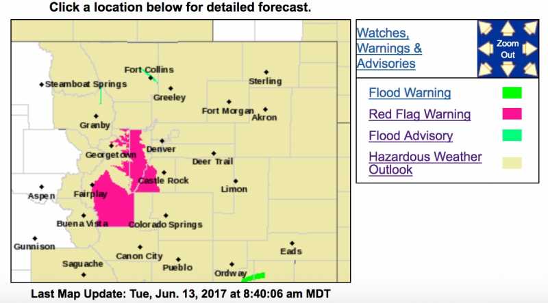
...RED FLAG WARNING IN EFFECT FROM 10 AM THIS MORNING TO 7 PM MDT
THIS EVENING FOR WIND AND LOW RELATIVE HUMIDITY FOR SOUTH PARK AND
THE SOUTHERN FRONT RANGE FOOTHILLS...
The National Weather Service in Denver has issued a Red Flag Warning FOR WIND AND LOW RELATIVE HUMIDITY...which is in effect from 10 AM this morning to 7 PM MDT this evening.
* Affected Area...Fire Weather Zones 214 and 216.
* Timing...Winds increasing and humidities dropping late this morning through the afternoon. Conditions will improve this evening.
* Winds...West 15 to 20 mph with gusts up to 35 mph.
* Relative Humidity...as low as 10 percent.
* Impacts...Low humidity values and gusty winds will result in high fire danger. These conditions may allow for fast burning wildfires. Open burning is prohibited on Red Flag days.
PRECAUTIONARY/PREPAREDNESS ACTIONS...
A Red Flag Warning means that critical fire weather conditions are either occurring now....or will shortly. A combination of strong winds...low relative humidity...and warm temperatures can contribute to extreme fire behavior.