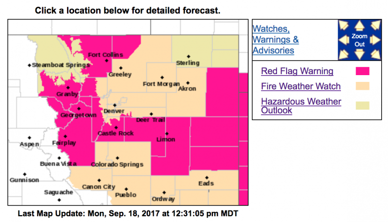
Red Flag Warning
URGENT - FIRE WEATHER MESSAGE
National Weather Service Denver/Boulder CO
1047 AM MDT Mon Sep 18 2017
...Critical to Extreme Fire Weather Conditions Expected Tuesday...
.West to southwest winds will increase Tuesday ahead of a cold front. Gusts to 50 mph will be possible over the higher terrain with gusts to 40 mph at lower elevations. These winds combined with relative humidity values of 7 to 15 percent will result in extreme fire weather conditions in places. Winds are expected to shift to the north Tuesday evening as the cold front pushes through. Relative humidities are expected to rapidly improve behind the cold front.
COZ214>216-241-246-247-190100-
/O.UPG.KBOU.FW.A.0020.170919T1800Z-170920T0000Z/
/O.NEW.KBOU.FW.W.0024.170919T1700Z-170920T0200Z/
Central and Southeast Park County-
Larimer and Boulder Counties Between 6000 and 9000 Feet-
Jefferson and West Douglas Counties Above 6000 Feet/Gilpin/Clear
Creek/Northeast Park Counties Below 9000 Feet-
Elbert/Central and East Douglas Counties Above 6000 Feet-
North and Northeast Elbert County Below 6000 Feet/North Lincoln
County-
Southeast Elbert County Below 6000 Feet/South Lincoln County-
1047 AM MDT Mon Sep 18 2017
...
RED FLAG WARNING IN EFFECT FROM 11 AM TO 8 PM MDT TUESDAY FOR
WIND AND LOW RELATIVE HUMIDITY FOR PARTS OF NORTH CENTRAL AND
NORTHEAST COLORADO...
The National Weather Service in Denver has issued a Red Flag Warning for wind and low relative humidity...which is in effect from 11 AM to 8 PM MDT Tuesday. The Fire Weather Watch is no longer in effect.
* Affected Area...Fire Weather Zones 214...215...216...241...246 and 247.
* Timing...Tuesday. 11 AM through 8 PM.
* Winds...Southwest 15 to 30 mph with gusts up to 50 mph in the mountains and foothills. Gusts up to 40 mph are expected across the lower elevations.
* Relative Humidity...as low as 8 percent.
* Impacts...Gusty winds and low relative humidity will result in critical fire weather conditions. Very windy conditions with relative humidities around 10 percent may result in extreme fire weather conditions for areas in and near the foothills.
PRECAUTIONARY/PREPAREDNESS ACTIONS...
A Red Flag Warning means that critical fire weather conditions are either occurring now....or will shortly. A combination of strong winds...low relative humidity...and warm temperatures can contribute to extreme fire behavior.
&&
$$
URGENT - FIRE WEATHER MESSAGE
National Weather Service Denver/Boulder CO
1047 AM MDT Mon Sep 18 2017
...Critical to Extreme Fire Weather Conditions Expected
Tuesday...
.West to southwest winds will increase Tuesday ahead of a cold front. Gusts to 50 mph will be possible over the higher terrain with gusts to 40 mph at lower elevations. These winds combined with relative humidity values of 7 to 15 percent will result in extreme fire weather conditions in places. Winds are expected to shift to the north Tuesday evening as the cold front pushes through. Relative humidities are expected to rapidly improve behind the cold front.
COZ212-213-238-190100-
/O.NEW.KBOU.FW.W.0024.170919T1700Z-170920T0200Z/
South and Southeast Grand/West Central and Southwest Boulder/
Gilpin/Clear Creek/Summit/North and West Park Counties Above
9000 Feet-Grand and Summit Counties Below 9000 Feet-
Larimer County Below 6000 Feet/Northwest Weld County-
1047 AM MDT Mon Sep 18 2017
...RED FLAG WARNING IN EFFECT FROM 11 AM TO 8 PM MDT TUESDAY FOR
WIND AND LOW RELATIVE HUMIDITY FOR PARTS OF NORTH CENTRAL AND
NORTHEAST COLORADO...
The National Weather Service in Denver has issued a Red Flag Warning for wind and low relative humidity...which is in effect from 11 AM to 8 PM MDT Tuesday.
* Affected Area...Fire Weather Zones 212...213 and 238.
* Timing...11 AM to 8 PM MDT Tuesday
* Winds...Southwest 20 to 30 mph with gusts up to 50 mph.
* Relative Humidity...as low as 7 percent.
* Impacts...Gusty winds and low relative humidity will result in critical fire weather conditions. Very windy conditions with relative humidities around 10 percent may result in extreme fire weather conditions in areas.
PRECAUTIONARY/PREPAREDNESS ACTIONS...
A Red Flag Warning means that critical fire weather conditions are either occurring now....or will shortly. A combination of strong winds...low relative humidity...and warm temperatures can contribute to extreme fire behavior.