- Posts: 9766
- Thank you received: 221
- Forum
- Life Up the Hill
- Scanner & Emergency Info, Weather Forecasts
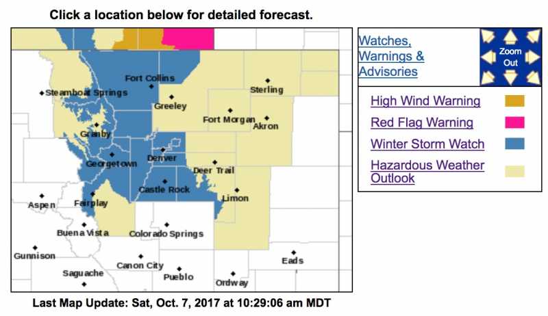
- Winter Storm Watch Sunday Evening Thru Monday Afternoon
Winter Storm Watch Sunday Evening Thru Monday Afternoon
- MountainTownAlerts
-
 Topic Author
- Mountain Legend
-

Less
More
07 Oct 2017 10:42 #1
by MountainTownAlerts
URGENT - WINTER WEATHER MESSAGE
National Weather Service Denver CO
1013 AM MDT Sat Oct 7 2017
...SEASON`S FIRST ACCUMULATING SNOW EXPECTED FOR THE I-25 CORRIDOR...
.A strong cold front and upper level storm system will move into the area Sunday evening. Temperatures will drop rapidly with the passage of the cold front. Snow will develop over the mountains and higher foothills, with rain developing during the evening in lower elevations. Temperatures will turn cold enough for rain to change over to snow across most of the I-25 Corridor toward the midnight hours and then across the eastern plains late Sunday night or Monday morning.
The mild weather today and most of Sunday would make an excellent time to prepare for winter`s return. Check car tires and ensure your emergency kits, flashlights, blankets, ice scrapers etc. are in place and all ready to go. Drain outdoor sprinkler systems to protect them from the well below freezing temperatures expected by Monday night.
COZ033>036-080015-
/O.CON.KBOU.WS.A.0015.171009T0300Z-171010T0000Z/
Rocky Mountain National Park and the Medicine Bow Range-The Mountains of Summit County, the Mosquito Range, and the Indian Peaks-The Northern Front Range Foothills-The Southern Front Range Foothills
Including the cities of Cameron Pass, Laramie and Medicine Bow Mountains, Rabbit Ears Range, Rocky Mountain National Park, Willow Creek Pass, Berthoud Pass, Breckenridge, East Slopes Mosquito Range, East Slopes Southern Gore Range, Eisenhower Tunnel, Indian Peaks, Kenosha Mountains, Mount Evans, Williams Fork Mountains, Winter Park, Estes Park, Glendevey, Nederland, Red Feather Lakes, Bailey, Central City, Evergreen, Georgetown, Idaho Springs, and Westcreek
1013 AM MDT Sat Oct 7 2017
...WINTER STORM WATCH REMAINS IN EFFECT FROM SUNDAY EVENING THROUGH MONDAY AFTERNOON...
* WHAT...Heavy snow possible. Plan on difficult travel conditions, including during the morning commute on Monday. Total snow accumulations of 5 to 10 inches, with localized amounts up to 14 inches, are possible.
* WHERE...Rocky Mountain National Park and the Medicine Bow Range, The Mountains of Summit County, the Mosquito Range, and the Indian Peaks, The Northern Front Range Foothills and The Southern Front Range Foothills.
* WHEN...From Sunday evening through Monday afternoon.
* ADDITIONAL DETAILS...Significant reductions in visibility are possible. Scattered power outages may occur due to heavy snow accumulating on trees still bearing their leaves.
PRECAUTIONARY/PREPAREDNESS ACTIONS...
A Winter Storm Watch means there is potential for significant snow, sleet or ice accumulations that may impact travel. Continue to monitor the latest forecasts.
URGENT - WINTER WEATHER MESSAGE
National Weather Service Denver CO
1013 AM MDT Sat Oct 7 2017
...SEASON`S FIRST ACCUMULATING SNOW EXPECTED FOR THE
I-25 CORRIDOR...
.A strong cold front and upper level storm system will move into
the area Sunday evening. Temperatures will drop rapidly with the
passage of the cold front. Snow will develop over the mountains
and higher foothills, with rain developing during the evening in
lower elevations. Temperatures will turn cold enough for rain to
change over to snow across most of the I-25 Corridor toward the
midnight hours and then across the eastern plains late Sunday
night or Monday morning.
The mild weather today and most of Sunday would make an excellent
time to prepare for winter`s return. Check car tires and ensure
your emergency kits, flashlights, blankets, ice scrapers etc. are
in place and all ready to go. Drain outdoor sprinkler systems to
protect them from the well below freezing temperatures expected
by Monday night.
COZ038>041-080015-
/O.CON.KBOU.WS.A.0015.171009T0600Z-171010T0000Z/
Fort Collins-Boulder and the western suburbs of Denver-Denver-
Castle Rock-
Including the cities of Fort Collins, Hereford, Loveland, Nunn,
Arvada, Boulder, Golden, Lakewood, Longmont, Aurora, Brighton,
City of Denver, Denver International Airport, Highlands Ranch,
Littleton, Parker, Castle Rock, Elbert, Fondis, Kiowa,
and Larkspur
1013 AM MDT Sat Oct 7 2017
...WINTER STORM WATCH REMAINS IN EFFECT FROM LATE SUNDAY NIGHT
THROUGH MONDAY AFTERNOON...
* WHAT...Heavy snow possible. Plan on possible hazardous travel
conditions, including the morning commute on Monday. Total
snow accumulations of 4 to 6 inches are possible.
* WHERE...Fort Collins, Boulder, Denver, and Castle Rock.
* WHEN...From late Sunday night through Monday afternoon.
* ADDITIONAL DETAILS...Scattered power outages may occur due to
heavy wet snow accumulating on trees still bearing their
leaves.
PRECAUTIONARY/PREPAREDNESS ACTIONS...
A Winter Storm Watch means there is potential for significant
snow, sleet or ice accumulations that may impact travel. Continue
to monitor the latest forecasts.
URGENT - WINTER WEATHER MESSAGE
National Weather Service Denver CO
1013 AM MDT Sat Oct 7 2017
...SEASON`S FIRST ACCUMULATING SNOW EXPECTED FOR THE I-25 CORRIDOR...
.A strong cold front and upper level storm system will move into the area Sunday evening. Temperatures will drop rapidly with the passage of the cold front. Snow will develop over the mountains and higher foothills, with rain developing during the evening in lower elevations. Temperatures will turn cold enough for rain to change over to snow across most of the I-25 Corridor toward the midnight hours and then across the eastern plains late Sunday night or Monday morning.
The mild weather today and most of Sunday would make an excellent time to prepare for winter`s return. Check car tires and ensure your emergency kits, flashlights, blankets, ice scrapers etc. are in place and all ready to go. Drain outdoor sprinkler systems to protect them from the well below freezing temperatures expected by Monday night.
COZ033>036-080015-
/O.CON.KBOU.WS.A.0015.171009T0300Z-171010T0000Z/
Rocky Mountain National Park and the Medicine Bow Range-The Mountains of Summit County, the Mosquito Range, and the Indian Peaks-The Northern Front Range Foothills-The Southern Front Range Foothills
Including the cities of Cameron Pass, Laramie and Medicine Bow Mountains, Rabbit Ears Range, Rocky Mountain National Park, Willow Creek Pass, Berthoud Pass, Breckenridge, East Slopes Mosquito Range, East Slopes Southern Gore Range, Eisenhower Tunnel, Indian Peaks, Kenosha Mountains, Mount Evans, Williams Fork Mountains, Winter Park, Estes Park, Glendevey, Nederland, Red Feather Lakes, Bailey, Central City, Evergreen, Georgetown, Idaho Springs, and Westcreek
1013 AM MDT Sat Oct 7 2017
...WINTER STORM WATCH REMAINS IN EFFECT FROM SUNDAY EVENING THROUGH MONDAY AFTERNOON...
* WHAT...Heavy snow possible. Plan on difficult travel conditions, including during the morning commute on Monday. Total snow accumulations of 5 to 10 inches, with localized amounts up to 14 inches, are possible.
* WHERE...Rocky Mountain National Park and the Medicine Bow Range, The Mountains of Summit County, the Mosquito Range, and the Indian Peaks, The Northern Front Range Foothills and The Southern Front Range Foothills.
* WHEN...From Sunday evening through Monday afternoon.
* ADDITIONAL DETAILS...Significant reductions in visibility are possible. Scattered power outages may occur due to heavy snow accumulating on trees still bearing their leaves.
PRECAUTIONARY/PREPAREDNESS ACTIONS...
A Winter Storm Watch means there is potential for significant snow, sleet or ice accumulations that may impact travel. Continue to monitor the latest forecasts.
URGENT - WINTER WEATHER MESSAGE
National Weather Service Denver CO
1013 AM MDT Sat Oct 7 2017
...SEASON`S FIRST ACCUMULATING SNOW EXPECTED FOR THE
I-25 CORRIDOR...
.A strong cold front and upper level storm system will move into
the area Sunday evening. Temperatures will drop rapidly with the
passage of the cold front. Snow will develop over the mountains
and higher foothills, with rain developing during the evening in
lower elevations. Temperatures will turn cold enough for rain to
change over to snow across most of the I-25 Corridor toward the
midnight hours and then across the eastern plains late Sunday
night or Monday morning.
The mild weather today and most of Sunday would make an excellent
time to prepare for winter`s return. Check car tires and ensure
your emergency kits, flashlights, blankets, ice scrapers etc. are
in place and all ready to go. Drain outdoor sprinkler systems to
protect them from the well below freezing temperatures expected
by Monday night.
COZ038>041-080015-
/O.CON.KBOU.WS.A.0015.171009T0600Z-171010T0000Z/
Fort Collins-Boulder and the western suburbs of Denver-Denver-
Castle Rock-
Including the cities of Fort Collins, Hereford, Loveland, Nunn,
Arvada, Boulder, Golden, Lakewood, Longmont, Aurora, Brighton,
City of Denver, Denver International Airport, Highlands Ranch,
Littleton, Parker, Castle Rock, Elbert, Fondis, Kiowa,
and Larkspur
1013 AM MDT Sat Oct 7 2017
...WINTER STORM WATCH REMAINS IN EFFECT FROM LATE SUNDAY NIGHT
THROUGH MONDAY AFTERNOON...
* WHAT...Heavy snow possible. Plan on possible hazardous travel
conditions, including the morning commute on Monday. Total
snow accumulations of 4 to 6 inches are possible.
* WHERE...Fort Collins, Boulder, Denver, and Castle Rock.
* WHEN...From late Sunday night through Monday afternoon.
* ADDITIONAL DETAILS...Scattered power outages may occur due to
heavy wet snow accumulating on trees still bearing their
leaves.
PRECAUTIONARY/PREPAREDNESS ACTIONS...
A Winter Storm Watch means there is potential for significant
snow, sleet or ice accumulations that may impact travel. Continue
to monitor the latest forecasts.
Please Log in or Create an account to join the conversation.
- MountainTownAlerts
-
Topic Author
- Mountain Legend
-
Less
More
- Posts: 9766
- Thank you received: 221
08 Oct 2017 10:15 #2
by MountainTownAlerts
Replied by MountainTownAlerts on topic Winter Storm Watch Sunday Evening Thru Monday Afternoon
The Winter Storm Watch has now been upgraded to a Winter Storm Warning.
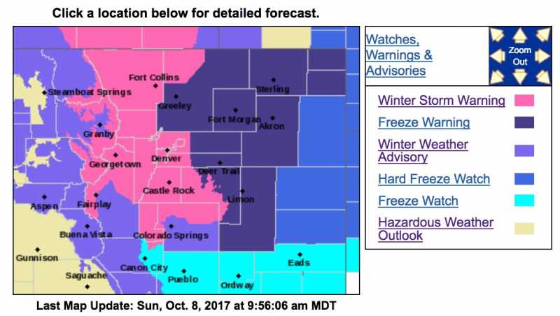
Winter Storm Warning
URGENT - WINTER WEATHER MESSAGE
National Weather Service Denver CO
414 AM MDT Sun Oct 8 2017
...SEASON`S FIRST ACCUMULATING SNOW EXPECTED FOR THE I-25 CORRIDOR...
.A strong cold front and upper level storm system will move into the area this evening. Temperatures will drop rapidly with the passage of the cold front. Snow will develop over the mountains and higher foothills, with rain developing and spreading south during the evening in lower elevations. Temperatures will turn cold enough for rain to change over to snow across most of the I-25 Corridor towards the midnight hour and then across the eastern plains late Sunday night into early Monday morning.
The mild weather today would make an excellent time to prepare for winter`s return. Check car tires and ensure your emergency kits, flashlights, blankets, ice scrapers etc. are in place and all ready to go. Drain outdoor sprinkler systems to protect them from the well below freezing temperatures expected by Monday night.
COZ033>036-081815-
/O.UPG.KBOU.WS.A.0015.171009T0300Z-171010T0000Z/
/O.NEW.KBOU.WS.W.0013.171009T0300Z-171009T2100Z/
Rocky Mountain National Park and the Medicine Bow Range-The Mountains of Summit County, the Mosquito Range, and the Indian Peaks-The Northern Front Range Foothills-The Southern Front Range Foothills-
Including the cities of Cameron Pass, Laramie and Medicine Bow Mountains, Rabbit Ears Range, Rocky Mountain National Park, Willow Creek Pass, Berthoud Pass, Breckenridge, East Slopes Mosquito Range, East Slopes Southern Gore Range, Eisenhower Tunnel, Indian Peaks, Kenosha Mountains, Mount Evans, Williams Fork Mountains, Winter Park, Estes Park, Glendevey, Nederland, Red Feather Lakes, Bailey, Central City, Evergreen, Georgetown, Idaho Springs, and Westcreek
414 AM MDT Sun Oct 8 2017
...WINTER STORM WARNING IN EFFECT FROM 9 PM THIS EVENING TO 3 PM MDT MONDAY...
* WHAT...Heavy snow expected. Plan on difficult travel conditions, including during the morning commute on Monday. Total snow accumulations of 6 to 10 inches, with localized amounts up to 14 inches, are expected.
* WHERE...Rocky Mountain National Park and the Medicine Bow Range, The Mountains of Summit County, the Mosquito Range, and the Indian Peaks, The Northern Front Range Foothills and The Southern Front Range Foothills.
* WHEN...Snow will develop from north to south this evening and become heavy at times overnight. Snow will decrease by Monday afternoon.
* ADDITIONAL DETAILS...Be prepared for significant reductions in visibility at times.
PRECAUTIONARY/PREPAREDNESS ACTIONS...
A Winter Storm Warning for snow means severe winter weather conditions are expected. If you must travel, keep an extra flashlight, food and water in your vehicle in case of an emergency. The latest road conditions for the state you are calling from can be obtained by calling 5 1 1.
URGENT - WINTER WEATHER MESSAGE
National Weather Service Denver CO
414 AM MDT Sun Oct 8 2017
...SEASON`S FIRST ACCUMULATING SNOW EXPECTED FOR THE I-25 CORRIDOR...
.A strong cold front and upper level storm system will move into the area this evening. Temperatures will drop rapidly with the passage of the cold front. Snow will develop over the mountains and higher foothills, with rain developing and spreading south during the evening in lower elevations. Temperatures will turn cold enough for rain to change over to snow across most of the I-25 Corridor towards the midnight hour and then across the eastern plains late Sunday night into early Monday morning.
The mild weather today would make an excellent time to prepare for winter`s return. Check car tires and ensure your emergency kits, flashlights, blankets, ice scrapers etc. are in place and all ready to go. Drain outdoor sprinkler systems to protect them from the well below freezing temperatures expected by Monday night.
COZ038>041-081815-
/O.UPG.KBOU.WS.A.0015.171009T0600Z-171010T0000Z/
/O.NEW.KBOU.WS.W.0013.171009T0600Z-171009T2100Z/
Fort Collins-Boulder and the western suburbs of Denver-Denver-Castle Rock-
Including the cities of Fort Collins, Hereford, Loveland, Nunn, Arvada, Boulder, Golden, Lakewood, Longmont, Aurora, Brighton, City of Denver, Denver International Airport, Highlands Ranch, Littleton, Parker, Castle Rock, Elbert, Fondis, Kiowa, and Larkspur
414 AM MDT Sun Oct 8 2017
...WINTER STORM WARNING IN EFFECT FROM MIDNIGHT TONIGHT TO 3 PM MDT MONDAY...
* WHAT...Heavy snow expected. Some secondary roads and bridges and overpasses may become snow or slush covered. Plan on slow and hazardous travel conditions, including during the morning commute on Monday. Total snow accumulations of 4 to 7 inches are expected, heaviest amounts near the foothills.
* WHERE...Fort Collins, Boulder, Denver and Castle Rock.
* WHEN...Midnight to 3 PM Monday.
* ADDITIONAL DETAILS...Scattered power outages may occur due to heavy wet snow accumulating on trees still bearing their leaves.
PRECAUTIONARY/PREPAREDNESS ACTIONS...
A Winter Storm Warning for snow means severe winter weather conditions are expected. If you must travel, keep an extra flashlight, food and water in your vehicle in case of an emergency. The latest road conditions for the state you are calling from can be obtained by calling 5 1 1.
Please Log in or Create an account to join the conversation.
- Forum
- Life Up the Hill
- Scanner & Emergency Info, Weather Forecasts
- Winter Storm Watch Sunday Evening Thru Monday Afternoon
Time to create page: 0.165 seconds
sponsors


