From Elk Creek Fire Department Chief Bill McLaughlin:
Please use caution with all ignition sources.
We are again at near critical fire weather for today. Relative Humidity is forecast to be 10%-14% and winds could gust to 35mph. Temperatures could reach 70 degrees. Conditions will change tonight as colder weather moves in.
Hazardous Weather Outlook
National Weather Service Denver/Boulder CO
531 AM MST Mon Nov 27 2017
COZ030>051-281245-
Jackson County Below 9000 Feet-
West Jackson and West Grand Counties Above 9000 Feet-
Grand and Summit Counties Below 9000 Feet-
South and East Jackson/Larimer/North and Northeast Grand/
Northwest Boulder Counties Above 9000 Feet-
South and Southeast Grand/West Central and Southwest Boulder/
Gilpin/Clear Creek/Summit/North and West Park Counties Above
9000 Feet-Larimer and Boulder Counties Between 6000 and 9000 Feet-
Jefferson and West Douglas Counties Above 6000 Feet/Gilpin/Clear
Creek/Northeast Park Counties Below 9000 Feet-
Central and Southeast Park County-
Larimer County Below 6000 Feet/Northwest Weld County-
Boulder And Jefferson Counties Below 6000 Feet/West Broomfield
County-
North Douglas County Below 6000 Feet/Denver/West Adams and
Arapahoe Counties/East Broomfield County-
Elbert/Central and East Douglas Counties Above 6000 Feet-
Northeast Weld County-Central and South Weld County-Morgan County-
Central and East Adams and Arapahoe Counties-
North and Northeast Elbert County Below 6000 Feet/North Lincoln
County-
Southeast Elbert County Below 6000 Feet/South Lincoln County-
Logan County-Washington County-Sedgwick County-Phillips County-
531 AM MST Mon Nov 27 2017
...
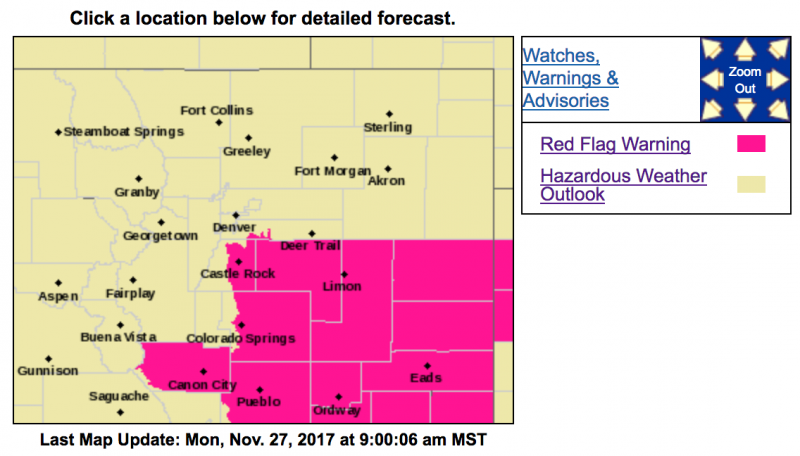
RED FLAG WARNING ON THE PALMER DIVIDE THIS AFTERNOON FOR GUSTY WINDS AND LOW HUMIDITIES MAKING DANGEROUS FIRE BEHAVIOR POSSIBLE...
This hazardous weather outlook is for northeast and north central Colorado.
.DAY ONE...Today and Tonight
Dry and unseasonably warm temperatures are expected again today. High temperatures across the plains this afternoon will be in the 70s along with breezy southwest winds on the Palmer Divide. The late season warm spell along with the gusty winds will raise fire danger levels and make dangerous fire behavior possible if a fire were to get started. A Red Flag Warning will be in effect over the Palmer Divide this afternoon.
Big changes to the weather are expected tonight as a fast moving upper level disturbance moves across Colorado. Snow is expected to fall in the mountains tonight with a few inches of new snow by sunrise Tuesday. On the plains, a strong cold front will move in from the north with gusty north winds and cooling temperatures through the evening. Rain showers are also expected to develop which will change over to snow after midnight. Snow accumulations over the I-25 corridor are expected to be less than an inch.
.DAYS TWO THROUGH SEVEN...Tuesday through Sunday
Some light snow will linger into Tuesday morning, mainly across the higher terrain and over the Palmer Divide. Additional accumulations will be generally an inch or less. For Wednesday through Sunday it will be dry with breezy conditions at times.
.SPOTTER INFORMATION STATEMENT...
Spotter activation will not be needed today or tonight.