- Posts: 9766
- Thank you received: 221
- Forum
- Life Up the Hill
- Scanner & Emergency Info, Weather Forecasts
- Winter Storm Warning late Saturday thru Sunday morning
Winter Storm Warning late Saturday thru Sunday morning
- MountainTownAlerts
-
 Topic Author
- Mountain Legend
-

Less
More
19 Jan 2018 19:12 - 20 Jan 2018 08:20 #1
by MountainTownAlerts
From Chief Meteorologist Steve Hamilton: Winter Storm Watch for the Colorado Front Range Foothills and part of the Eastern Plains. Issued by @NWSBoulder The Watch is for Sat evening through Sun morning. 6 to 12 inches possible. #cowx
ADVISORY- The National Weather Service forecasts widespread snow to develop late Saturday night on the I-70 Mountain Corridor and continue into Sunday. The heaviest snow and strongest winds are expected to occur late Saturday into early Sunday. Expect mountain roads to become snow covered and slippery with Traction and Chain Laws in effect by late Saturday and those conditions to last through Sunday.
URGENT - WINTER WEATHER MESSAGE
National Weather Service Denver CO
154 PM MST Fri Jan 19 2018
...Winter Storm Bringing Snow and Gusty Winds to Portions of
Northeast and North Central Colorado This Weekend...
.A Pacific storm system tracking across Colorado this weekend
will bring snow, possibly heavy at times, to the mountains and
plains of north central and northeast Colorado beginning in the
high country Saturday evening. Snow is expected to spread out
across the northeast plains of Colorado Saturday night, where
snowfall may be accompanied by northerly winds of 25 to 40 mph
Sunday afternoon. The gusty winds may produce areas of blowing
snow which may reduce visibilities in blowing snow. Snowfall is
expected to decrease from west to east Sunday afternoon and
evening, ending on the far northeast plains of Colorado by
midnight Sunday night.
COZ031-033>036-200500-
/O.NEW.KBOU.WS.A.0001.180121T0100Z-180121T1900Z/
Rabbit Ears Pass- Rocky Mountain National Park and the Medicine Bow Range- The Mountains of Summit County, the Mosquito Range, and the Indian Peaks-The Northern Front Range Foothills- The Southern Front Range Foothills- Including the cities of: East Slopes Park and Northern Gore Ranges, Gore Pass, Rabbit Ears Pass, Cameron Pass, Laramie and Medicine Bow Mountains, Rabbit Ears Range, Rocky Mountain National Park, Willow Creek Pass, Berthoud Pass, Breckenridge, East Slopes Mosquito Range, East Slopes Southern Gore Range, Eisenhower Tunnel, Indian Peaks, Kenosha Mountains, Mount Evans, Williams Fork Mountains,
Winter Park, Estes Park, Glendevey, Nederland, Red Feather Lakes,
Bailey, Central City, Evergreen, Georgetown, Idaho Springs,
and Westcreek
154 PM MST Fri Jan 19 2018
...WINTER STORM WATCH IN EFFECT FROM SATURDAY EVENING THROUGH SUNDAY MORNING...
* WHAT...Heavy snow possible. Plan on difficult travel conditions. Total snow accumulations of 6 to 12 inches, with localized amounts up to 20 inches, are possible.
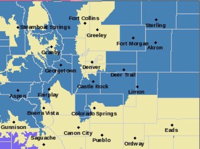
* WHERE...Rabbit Ears Pass, Rocky Mountain National Park and the Medicine Bow Range, The Mountains of Summit County, the Mosquito Range, and the Indian Peaks, The Northern Front Range Foothills and The Southern Front Range Foothills.
* WHEN...From Saturday evening through Sunday morning.
* ADDITIONAL DETAILS...Significant reductions in visibility are possible, particularly on the high mountain passes.
PRECAUTIONARY/PREPAREDNESS ACTIONS...
A Winter Storm Watch means there is potential for significant snow, sleet or ice accumulations that may impact travel. Continue to monitor the latest forecasts.
From Chief Meteorologist Steve Hamilton: Winter Storm Watch for the Colorado Front Range Foothills and part of the Eastern Plains. Issued by @NWSBoulder The Watch is for Sat evening through Sun morning. 6 to 12 inches possible. #cowx
ADVISORY- The National Weather Service forecasts widespread snow to develop late Saturday night on the I-70 Mountain Corridor and continue into Sunday. The heaviest snow and strongest winds are expected to occur late Saturday into early Sunday. Expect mountain roads to become snow covered and slippery with Traction and Chain Laws in effect by late Saturday and those conditions to last through Sunday.
URGENT - WINTER WEATHER MESSAGE
National Weather Service Denver CO
154 PM MST Fri Jan 19 2018
...Winter Storm Bringing Snow and Gusty Winds to Portions of
Northeast and North Central Colorado This Weekend...
.A Pacific storm system tracking across Colorado this weekend
will bring snow, possibly heavy at times, to the mountains and
plains of north central and northeast Colorado beginning in the
high country Saturday evening. Snow is expected to spread out
across the northeast plains of Colorado Saturday night, where
snowfall may be accompanied by northerly winds of 25 to 40 mph
Sunday afternoon. The gusty winds may produce areas of blowing
snow which may reduce visibilities in blowing snow. Snowfall is
expected to decrease from west to east Sunday afternoon and
evening, ending on the far northeast plains of Colorado by
midnight Sunday night.
COZ031-033>036-200500-
/O.NEW.KBOU.WS.A.0001.180121T0100Z-180121T1900Z/
Rabbit Ears Pass- Rocky Mountain National Park and the Medicine Bow Range- The Mountains of Summit County, the Mosquito Range, and the Indian Peaks-The Northern Front Range Foothills- The Southern Front Range Foothills- Including the cities of: East Slopes Park and Northern Gore Ranges, Gore Pass, Rabbit Ears Pass, Cameron Pass, Laramie and Medicine Bow Mountains, Rabbit Ears Range, Rocky Mountain National Park, Willow Creek Pass, Berthoud Pass, Breckenridge, East Slopes Mosquito Range, East Slopes Southern Gore Range, Eisenhower Tunnel, Indian Peaks, Kenosha Mountains, Mount Evans, Williams Fork Mountains,
Winter Park, Estes Park, Glendevey, Nederland, Red Feather Lakes,
Bailey, Central City, Evergreen, Georgetown, Idaho Springs,
and Westcreek
154 PM MST Fri Jan 19 2018
...WINTER STORM WATCH IN EFFECT FROM SATURDAY EVENING THROUGH SUNDAY MORNING...
* WHAT...Heavy snow possible. Plan on difficult travel conditions. Total snow accumulations of 6 to 12 inches, with localized amounts up to 20 inches, are possible.
* WHERE...Rabbit Ears Pass, Rocky Mountain National Park and the Medicine Bow Range, The Mountains of Summit County, the Mosquito Range, and the Indian Peaks, The Northern Front Range Foothills and The Southern Front Range Foothills.
* WHEN...From Saturday evening through Sunday morning.
* ADDITIONAL DETAILS...Significant reductions in visibility are possible, particularly on the high mountain passes.
PRECAUTIONARY/PREPAREDNESS ACTIONS...
A Winter Storm Watch means there is potential for significant snow, sleet or ice accumulations that may impact travel. Continue to monitor the latest forecasts.
Last edit: 20 Jan 2018 08:20 by MountainTownAlerts.
Please Log in or Create an account to join the conversation.
- MountainTownAlerts
-
Topic Author
- Mountain Legend
-
Less
More
- Posts: 9766
- Thank you received: 221
20 Jan 2018 08:21 - 20 Jan 2018 10:10 #2
by MountainTownAlerts
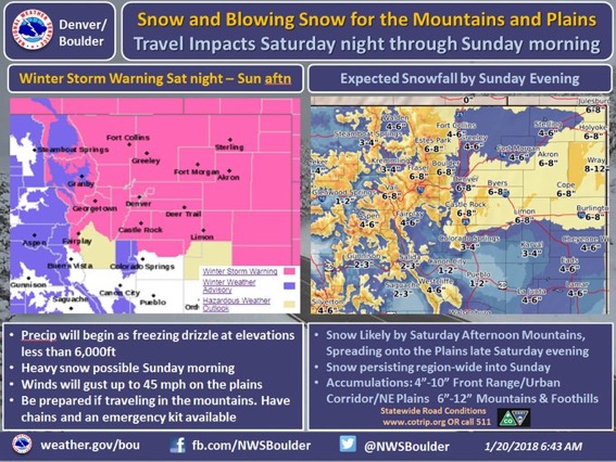
A winter storm warning has been issued for the northern mountains/foothills, urban corridor, & eastern plains. Snow & gusty winds will greatly reduce visibility & impact travel Saturday aft/eve through Sunday aft. At lower elevations, freezing drizzle will precede the snow. #cowx
RGENT - WINTER WEATHER MESSAGE
National Weather Service Denver CO
524 AM MST Sat Jan 20 2018
...Winter Storm Bringing Snow and Gusty Winds to Portions of
Northeast and North Central Colorado This Weekend...
.A Four Corners low will track across Colorado this weekend
bringing snow, possibly heavy at times, to the mountains and
plains of north central and northeast Colorado. Snow will begin
in the high country Saturday evening and spread east across the
northeast plains of Colorado late Saturday night and Sunday
morning. Prior to the snow, parts of northeast Colorado will see
freezing drizzle which will make roads very slippery.
As the storm intensifies northerly winds will increase to 25 to
40 mph by Sunday afternoon across the eastern plains. The gusty
winds will produce areas of blowing snow which may reduce
visibilities to less than a mile at times. Snowfall is expected to
decrease from west to east Sunday afternoon and evening.
COZ031-033>036-202030-
/O.UPG.KBOU.WS.A.0001.180121T0100Z-180121T1900Z/
/O.NEW.KBOU.WS.W.0001.180121T0100Z-180121T1900Z/
Rabbit Ears Pass-
Rocky Mountain National Park and the Medicine Bow Range-
The Mountains of Summit County, the Mosquito Range, and the
Indian Peaks-The Northern Front Range Foothills-
The Southern Front Range Foothills-
Including the cities of East Slopes Park and Northern Gore Ranges, Gore Pass, Rabbit Ears Pass, Cameron Pass, Laramie and Medicine Bow Mountains, Rabbit Ears Range, Rocky Mountain National Park, Willow Creek Pass, Berthoud Pass, Breckenridge, East Slopes Mosquito Range, East Slopes Southern Gore Range, Eisenhower Tunnel, Indian Peaks, Kenosha Mountains, Mount Evans, Williams Fork Mountains, Winter Park, Estes Park, Glendevey, Nederland, Red Feather Lakes, Bailey, Central City, Evergreen, Georgetown, Idaho Springs, and Westcreek
524 AM MST Sat Jan 20 2018
...WINTER STORM WARNING IN EFFECT FROM 6 PM THIS EVENING TO NOON MST SUNDAY...
* WHAT...Heavy snow expected. Plan on difficult travel conditions. Total snow accumulations of 6 to 12 inches, with localized amounts up to 18 inches.
* WHERE...Rabbit Ears Pass, Rocky Mountain National Park and the Medicine Bow Range, The Mountains of Summit County, the Mosquito Range, and the Indian Peaks, The Northern Front Range Foothills and The Southern Front Range Foothills.
* WHEN...From 6 PM this evening to noon MST Sunday.
* ADDITIONAL DETAILS...Be prepared for snow covered and slippery roads. Significant reductions in visibility at times are expected.
PRECAUTIONARY/PREPAREDNESS ACTIONS...
A Winter Storm Warning means significant amounts of snow, sleet and ice are expected. This will make travel very hazardous or impossible. The latest road conditions for the state you are calling from can be obtained by calling 5 1 1.
Replied by MountainTownAlerts on topic Winter Storm Warning late Saturday thru Sunday morning
A winter storm warning has been issued for the northern mountains/foothills, urban corridor, & eastern plains. Snow & gusty winds will greatly reduce visibility & impact travel Saturday aft/eve through Sunday aft. At lower elevations, freezing drizzle will precede the snow. #cowx
RGENT - WINTER WEATHER MESSAGE
National Weather Service Denver CO
524 AM MST Sat Jan 20 2018
...Winter Storm Bringing Snow and Gusty Winds to Portions of
Northeast and North Central Colorado This Weekend...
.A Four Corners low will track across Colorado this weekend
bringing snow, possibly heavy at times, to the mountains and
plains of north central and northeast Colorado. Snow will begin
in the high country Saturday evening and spread east across the
northeast plains of Colorado late Saturday night and Sunday
morning. Prior to the snow, parts of northeast Colorado will see
freezing drizzle which will make roads very slippery.
As the storm intensifies northerly winds will increase to 25 to
40 mph by Sunday afternoon across the eastern plains. The gusty
winds will produce areas of blowing snow which may reduce
visibilities to less than a mile at times. Snowfall is expected to
decrease from west to east Sunday afternoon and evening.
COZ031-033>036-202030-
/O.UPG.KBOU.WS.A.0001.180121T0100Z-180121T1900Z/
/O.NEW.KBOU.WS.W.0001.180121T0100Z-180121T1900Z/
Rabbit Ears Pass-
Rocky Mountain National Park and the Medicine Bow Range-
The Mountains of Summit County, the Mosquito Range, and the
Indian Peaks-The Northern Front Range Foothills-
The Southern Front Range Foothills-
Including the cities of East Slopes Park and Northern Gore Ranges, Gore Pass, Rabbit Ears Pass, Cameron Pass, Laramie and Medicine Bow Mountains, Rabbit Ears Range, Rocky Mountain National Park, Willow Creek Pass, Berthoud Pass, Breckenridge, East Slopes Mosquito Range, East Slopes Southern Gore Range, Eisenhower Tunnel, Indian Peaks, Kenosha Mountains, Mount Evans, Williams Fork Mountains, Winter Park, Estes Park, Glendevey, Nederland, Red Feather Lakes, Bailey, Central City, Evergreen, Georgetown, Idaho Springs, and Westcreek
524 AM MST Sat Jan 20 2018
...WINTER STORM WARNING IN EFFECT FROM 6 PM THIS EVENING TO NOON MST SUNDAY...
* WHAT...Heavy snow expected. Plan on difficult travel conditions. Total snow accumulations of 6 to 12 inches, with localized amounts up to 18 inches.
* WHERE...Rabbit Ears Pass, Rocky Mountain National Park and the Medicine Bow Range, The Mountains of Summit County, the Mosquito Range, and the Indian Peaks, The Northern Front Range Foothills and The Southern Front Range Foothills.
* WHEN...From 6 PM this evening to noon MST Sunday.
* ADDITIONAL DETAILS...Be prepared for snow covered and slippery roads. Significant reductions in visibility at times are expected.
PRECAUTIONARY/PREPAREDNESS ACTIONS...
A Winter Storm Warning means significant amounts of snow, sleet and ice are expected. This will make travel very hazardous or impossible. The latest road conditions for the state you are calling from can be obtained by calling 5 1 1.
Last edit: 20 Jan 2018 10:10 by MountainTownAlerts.
Please Log in or Create an account to join the conversation.
- Forum
- Life Up the Hill
- Scanner & Emergency Info, Weather Forecasts
- Winter Storm Warning late Saturday thru Sunday morning
Time to create page: 0.166 seconds
sponsors


