CDOT ADVISORY- The National Weather Service forecasts widespread snow to develop late tonight on the I-70 Mountain Corridor and continue into Thursday. The heaviest snow and strongest winds are expected to occur early Thursday morning and last into the afternoon. Expect mountain roads to become snow covered and slippery with Traction and Chain Laws in effect by late tonight and those conditions to last through Thursday. Be prepared safety closures are possible. CDOT Winter Driving
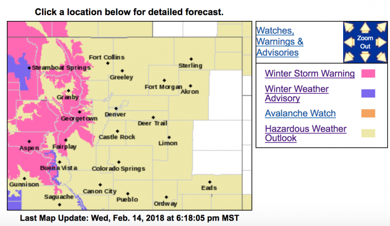
Winter Storm Warning
URGENT - WINTER WEATHER MESSAGE
National Weather Service Denver CO
356 PM MST Wed Feb 14 2018
...DIFFICULT TRAVEL CONDITIONS TONIGHT AND THURSDAY...
.Heavy snow and strong winds will create difficult travel conditions tonight and Thursday over the higher mountainous terrain of North Central Colorado. Snow will begin this evening over the northern mountains, spreading southward over the I-70 corridor after midnight and continue on Thursday. Snow will be heavy at times, with snowfall rates of 1 to 2 inches an hour possible. Strong winds up to 60 mph will create low visibility in blowing snow. Travel tonight and Thursday will be impacted, especially over mountain passes.
COZ034-150700-
/O.CON.KBOU.WS.W.0003.180215T0700Z-180216T0100Z/
The
Mountains of Summit County, the Mosquito Range, and the Indian Peaks-
Including the cities of Berthoud Pass, Breckenridge, East Slopes Mosquito Range, East Slopes Southern Gore Range, Eisenhower Tunnel, Indian Peaks, Kenosha Mountains, Mount Evans, Williams Fork Mountains, and Winter Park
356 PM MST Wed Feb 14 2018
...
WINTER STORM WARNING REMAINS IN EFFECT FROM MIDNIGHT TONIGHT TO 6 PM MST THURSDAY...
* WHAT...Heavy snow and blowing snow expected. Total
snow accumulations of 5 to 10 inches, with localized amounts up to 14 inches, are expected.
* WHERE...The Mountains of Summit County, the Mosquito Range, and the Indian Peaks.
* WHEN...From midnight tonight to 6 PM MST Thursday.
* ADDITIONAL DETAILS...Plan on difficult travel conditions, including during the morning commute on Thursday. Winds gusting as high as 55 mph will cause areas of blowing and drifting snow.
PRECAUTIONARY/PREPAREDNESS ACTIONS...
A Winter Storm Warning for snow and blowing snow means severe winter weather conditions will make travel very hazardous or impossible. If you must travel, keep an extra flashlight, food and water in your vehicle in case of an emergency. The latest road conditions for the state you are calling from can be obtained by calling 5 1 1.
URGENT - WINTER WEATHER MESSAGE
National Weather Service Denver CO
356 PM MST Wed Feb 14 2018
...DIFFICULT TRAVEL CONDITIONS TONIGHT AND THURSDAY...
.Heavy snow and strong winds will create difficult travel conditions tonight and Thursday over the higher mountainous terrain of North Central Colorado. Snow will begin this evening over the northern mountains, spreading southward over the I-70 corridor after midnight and continue on Thursday. Snow will be heavy at times, with snowfall rates of 1 to 2 inches an hour possible. Strong winds up to 60 mph will create low visibility in blowing snow. Travel tonight and Thursday will be impacted, especially over mountain passes.
COZ031-033-150700-
/O.CON.KBOU.WS.W.0003.180215T0000Z-180216T0100Z/
Rabbit Ears Pass-Rocky Mountain National Park and the Medicine Bow Range-
Including the cities of East Slopes Park and Northern Gore Ranges, Gore Pass, Rabbit Ears Pass, Cameron Pass, Laramie and Medicine Bow Mountains, Rabbit Ears Range, Rocky Mountain National Park, and Willow Creek Pass
356 PM MST Wed Feb 14 2018
...
WINTER STORM WARNING REMAINS IN EFFECT UNTIL 6 PM MST THURSDAY...
* WHAT...Heavy snow and blowing snow expected.
Total snow accumulations of 6 to 12 inches, with localized amounts up to 16 inches, are expected.
* WHERE...Rabbit Ears Pass and Rocky Mountain National Park and the Medicine Bow Range.
* WHEN...Until 6 PM MST Thursday.
* ADDITIONAL DETAILS...Plan on difficult travel conditions. Winds gusting as high as 55 mph will cause areas of blowing and drifting snow.
PRECAUTIONARY/PREPAREDNESS ACTIONS...
A Winter Storm Warning for snow and blowing snow means severe winter weather conditions will make travel very hazardous or impossible. If you must travel, keep an extra flashlight, food and water in your vehicle in case of an emergency. The latest road conditions for the state you are calling from can be obtained by calling 5 1 1.