- Posts: 9766
- Thank you received: 221
- Forum
- Life Up the Hill
- Scanner & Emergency Info, Weather Forecasts
- Red Flag Warning for Jeffco, lower ParkCo; Winter Weather Advisory upper ParkCo
Red Flag Warning for Jeffco, lower ParkCo; Winter Weather Advisory upper ParkCo
- MountainTownAlerts
-
 Topic Author
- Mountain Legend
-

Less
More
04 Mar 2018 07:06 #1
by MountainTownAlerts
URGENT - FIRE WEATHER MESSAGE
National Weather Service Denver/Boulder CO
356 AM MST Sun Mar 4 2018
...CRITICAL FIRE WEATHER CONDITIONS EXPECTED THROUGH MONDAY...
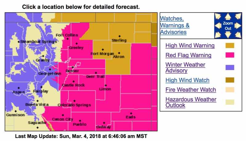
.Warm, dry and very windy conditions during the afternoon and early evening hours today ahead of and behind a strong cold front will again produce critical wildfire conditions. The critical conditions will encompass most of the plains as well as the southern foothills so the Red Flag Warning has been expanded. Southwest winds ahead of the front will shift to the west/northwest and increase with gusts to around 45 mph as the front sweeps across the plains late in the afternoon. The shifting winds may produce erratic fire behavior and growth of any existing fires.
Strong and gusty northwest winds and low relative humidity on Monday may again produce high fire danger on the plains on Monday. As a result, a Fire Weather Watch has been expanded to include all of northeast Colorado.
COZ216-041900-
/O.CON.KBOU.FW.W.0006.180304T1800Z-180305T0200Z/
Jefferson and West Douglas Counties Above 6000 Feet/Gilpin/ClearCreek/Northeast Park Counties Below 9000 Feet-
356 AM MST Sun Mar 4 2018
...RED FLAG WARNING REMAINS IN EFFECT FROM 11 AM THIS MORNING TO 7 PM MST THIS EVENING FOR WIND AND LOW RELATIVE HUMIDITY FOR THE SOUTHERN FRONT RANGE FOOTHILLS AND ADJACENT PLAINS EAST AND NORTHEAST THROUGH BOULDER AND FORT COLLINS...
* Affected Area...Fire Weather Zone 216.
* Timing...This afternoon into early evening.
* Winds...West 20 to 30 mph with gusts up to 50 mph.
* Relative Humidity...As low as 10 percent.
* Impacts...Gusty, shifting winds and low relative humidity during the afternoon will produce conditions favorable for fire starts and rapid growth.
PRECAUTIONARY/PREPAREDNESS ACTIONS...
A Red Flag Warning means that critical fire weather conditions are either occurring now....or will shortly. A combination of strong winds...low relative humidity...and warm temperatures can contribute to extreme fire behavior.
URGENT - FIRE WEATHER MESSAGE
National Weather Service Denver/Boulder CO
356 AM MST Sun Mar 4 2018
...CRITICAL FIRE WEATHER CONDITIONS EXPECTED THROUGH MONDAY...
.Warm, dry and very windy conditions during the afternoon and early evening hours today ahead of and behind a strong cold front will again produce critical wildfire conditions. The critical conditions will encompass most of the plains as well as the southern foothills so the Red Flag Warning has been expanded. Southwest winds ahead of the front will shift to the west/northwest and increase with gusts to around 45 mph as the front sweeps across the plains late in the afternoon. The shifting winds may produce erratic fire behavior and growth of any existing fires.
Strong and gusty northwest winds and low relative humidity on Monday may again produce high fire danger on the plains on Monday. As a result, a Fire Weather Watch has been expanded to include all of northeast Colorado.
COZ238>240-242>244-248-041900-
/O.EXA.KBOU.FW.A.0005.180305T1700Z-180306T0000Z/
/O.CON.KBOU.FW.W.0006.180304T1800Z-180305T0200Z/
Larimer County Below 6000 Feet/Northwest Weld County-
Boulder And Jefferson Counties Below 6000 Feet/West Broomfield
County-
North Douglas County Below 6000 Feet/Denver/West Adams and
Arapahoe Counties/East Broomfield County-Northeast Weld County-
Central and South Weld County-Morgan County-Logan County-
356 AM MST Sun Mar 4 2018
...RED FLAG WARNING REMAINS IN EFFECT FROM 11 AM THIS MORNING TO 7 PM MST THIS EVENING FOR WIND AND LOW RELATIVE HUMIDITY FOR THE SOUTHERN FRONT RANGE FOOTHILLS AND ADJACENT PLAINS EAST AND NORTHEAST THROUGH BOULDER AND FORT COLLINS...
...FIRE WEATHER WATCH IN EFFECT FROM MONDAY MORNING THROUGH
MONDAY AFTERNOON FOR WIND AND LOW RELATIVE HUMIDITY FROM DENVER
NORTH TO THE WYOMING AND EASTWARD...
The National Weather Service in Denver has issued a Fire Weather Watch FOR WIND AND LOW RELATIVE HUMIDITY, which is in effect from Monday morning through Monday afternoon.
* Affected Area...Fire Weather Zones 238...239...240...242... 243...244 and 248.
* Timing...This afternoon into the evening. Fire danger may increase again for Monday with strong winds.
* Winds...Southwest winds 15 to 25 mph with gusts increasing to 35 mph shifting to the west 20 to 30 mph with gusts up to 45 mph late in the afternoon. On Monday Northwest 25 to 40 mph with gusts from 50 to 60 mph.
* Relative Humidity...As low as 10 percent this afternoon. 10 to 15 percent Monday afternoon.
* Impacts...Conditions will be favorable for new fire starts and rapid growth of fires. Outdoor burning is prohibited.
PRECAUTIONARY/PREPAREDNESS ACTIONS...
A Red Flag Warning means that critical fire weather conditions are either occurring now....or will shortly. A combination of strong winds...low relative humidity...and warm temperatures can contribute to extreme fire behavior.
A Fire Weather Watch means that critical fire weather conditions are forecast to occur. Listen for later forecasts and possible Red Flag Warnings.
Winter Weather Advisory
URGENT - WINTER WEATHER MESSAGE
National Weather Service Denver CO
508 AM MST Sun Mar 4 2018
...Snow and strong winds Sunday afternoon through Monday morning...
.Light to moderate snowfall will develop over the north central mountains of Colorado Sunday afternoon as the next winter storm moves across Colorado. Expect a rapid deterioration in road conditions in the northern mountains with snow, blowing snow and falling temperatures late Sunday afternoon into the evening, affecting travel including the I-70 Corridor. Snowfall will continue in the high country of north central Colorado until Monday morning. The snow will be heaviest north of Rabbit Ears Pass.
Strong winds will also occur, strongest along and east of the Continental Divide Sunday night into Monday morning. Areas and drifting snow can be expected, especially over the higher mountain passes. The snow will decrease on Monday but strong gusty winds will persist through the day.
COZ031-033-034-042015-
/O.EXT.KBOU.WW.Y.0015.180304T2100Z-180305T1700Z/
Rabbit Ears Pass-
Rocky Mountain National Park and the Medicine Bow Range-
The Mountains of Summit County, the Mosquito Range, and the
Indian Peaks-
Including the cities of East Slopes Park and Northern Gore Ranges, Gore Pass, Rabbit Ears Pass, Cameron Pass, Laramie and Medicine Bow Mountains, Rabbit Ears Range, Rocky Mountain National Park, Willow Creek Pass, Berthoud Pass, Breckenridge, East Slopes Mosquito Range, East Slopes Southern Gore Range, Eisenhower Tunnel, Indian Peaks, Kenosha Mountains, Mount Evans, Williams Fork Mountains, and Winter Park
508 AM MST Sun Mar 4 2018
...WINTER WEATHER ADVISORY NOW IN EFFECT FROM 2 PM THIS AFTERNOON TO 10 AM MST MONDAY...
* WHAT...Snow and blowing snow expected. Total snow accumulations of 3 to 7 inches are expected.
* WHERE...Rabbit Ears Pass, Rocky Mountain National Park and the Medicine Bow Range and The Mountains of Summit County, the Mosquito Range, and the Indian Peaks.
* WHEN...From 2 PM this afternoon to 10 AM MST Monday.
* ADDITIONAL DETAILS...Plan on slippery road conditions. In addition, significant reductions in visibility are likely. Winds gusting as high as 60 mph will cause widespread blowing and drifting snow. The cold wind chills as low as 25 below zero could cause frostbite on exposed skin in as little as 30 minutes.
PRECAUTIONARY/PREPAREDNESS ACTIONS...
A Winter Weather Advisory for snow and blowing snow means periods of snow and blowing snow will cause primarily travel difficulties. Be prepared for snow covered roads and limited visibilities, and use caution while driving. The latest road conditions for the state you are calling from can be obtained by calling 5 1 1.
Red Flag Warning for Jeffco, lower ParkCo; Winter Weather Advisory upper ParkCo was created by MountainTownAlerts
URGENT - FIRE WEATHER MESSAGE
National Weather Service Denver/Boulder CO
356 AM MST Sun Mar 4 2018
...CRITICAL FIRE WEATHER CONDITIONS EXPECTED THROUGH MONDAY...
.Warm, dry and very windy conditions during the afternoon and early evening hours today ahead of and behind a strong cold front will again produce critical wildfire conditions. The critical conditions will encompass most of the plains as well as the southern foothills so the Red Flag Warning has been expanded. Southwest winds ahead of the front will shift to the west/northwest and increase with gusts to around 45 mph as the front sweeps across the plains late in the afternoon. The shifting winds may produce erratic fire behavior and growth of any existing fires.
Strong and gusty northwest winds and low relative humidity on Monday may again produce high fire danger on the plains on Monday. As a result, a Fire Weather Watch has been expanded to include all of northeast Colorado.
COZ216-041900-
/O.CON.KBOU.FW.W.0006.180304T1800Z-180305T0200Z/
Jefferson and West Douglas Counties Above 6000 Feet/Gilpin/ClearCreek/Northeast Park Counties Below 9000 Feet-
356 AM MST Sun Mar 4 2018
...RED FLAG WARNING REMAINS IN EFFECT FROM 11 AM THIS MORNING TO 7 PM MST THIS EVENING FOR WIND AND LOW RELATIVE HUMIDITY FOR THE SOUTHERN FRONT RANGE FOOTHILLS AND ADJACENT PLAINS EAST AND NORTHEAST THROUGH BOULDER AND FORT COLLINS...
* Affected Area...Fire Weather Zone 216.
* Timing...This afternoon into early evening.
* Winds...West 20 to 30 mph with gusts up to 50 mph.
* Relative Humidity...As low as 10 percent.
* Impacts...Gusty, shifting winds and low relative humidity during the afternoon will produce conditions favorable for fire starts and rapid growth.
PRECAUTIONARY/PREPAREDNESS ACTIONS...
A Red Flag Warning means that critical fire weather conditions are either occurring now....or will shortly. A combination of strong winds...low relative humidity...and warm temperatures can contribute to extreme fire behavior.
URGENT - FIRE WEATHER MESSAGE
National Weather Service Denver/Boulder CO
356 AM MST Sun Mar 4 2018
...CRITICAL FIRE WEATHER CONDITIONS EXPECTED THROUGH MONDAY...
.Warm, dry and very windy conditions during the afternoon and early evening hours today ahead of and behind a strong cold front will again produce critical wildfire conditions. The critical conditions will encompass most of the plains as well as the southern foothills so the Red Flag Warning has been expanded. Southwest winds ahead of the front will shift to the west/northwest and increase with gusts to around 45 mph as the front sweeps across the plains late in the afternoon. The shifting winds may produce erratic fire behavior and growth of any existing fires.
Strong and gusty northwest winds and low relative humidity on Monday may again produce high fire danger on the plains on Monday. As a result, a Fire Weather Watch has been expanded to include all of northeast Colorado.
COZ238>240-242>244-248-041900-
/O.EXA.KBOU.FW.A.0005.180305T1700Z-180306T0000Z/
/O.CON.KBOU.FW.W.0006.180304T1800Z-180305T0200Z/
Larimer County Below 6000 Feet/Northwest Weld County-
Boulder And Jefferson Counties Below 6000 Feet/West Broomfield
County-
North Douglas County Below 6000 Feet/Denver/West Adams and
Arapahoe Counties/East Broomfield County-Northeast Weld County-
Central and South Weld County-Morgan County-Logan County-
356 AM MST Sun Mar 4 2018
...RED FLAG WARNING REMAINS IN EFFECT FROM 11 AM THIS MORNING TO 7 PM MST THIS EVENING FOR WIND AND LOW RELATIVE HUMIDITY FOR THE SOUTHERN FRONT RANGE FOOTHILLS AND ADJACENT PLAINS EAST AND NORTHEAST THROUGH BOULDER AND FORT COLLINS...
...FIRE WEATHER WATCH IN EFFECT FROM MONDAY MORNING THROUGH
MONDAY AFTERNOON FOR WIND AND LOW RELATIVE HUMIDITY FROM DENVER
NORTH TO THE WYOMING AND EASTWARD...
The National Weather Service in Denver has issued a Fire Weather Watch FOR WIND AND LOW RELATIVE HUMIDITY, which is in effect from Monday morning through Monday afternoon.
* Affected Area...Fire Weather Zones 238...239...240...242... 243...244 and 248.
* Timing...This afternoon into the evening. Fire danger may increase again for Monday with strong winds.
* Winds...Southwest winds 15 to 25 mph with gusts increasing to 35 mph shifting to the west 20 to 30 mph with gusts up to 45 mph late in the afternoon. On Monday Northwest 25 to 40 mph with gusts from 50 to 60 mph.
* Relative Humidity...As low as 10 percent this afternoon. 10 to 15 percent Monday afternoon.
* Impacts...Conditions will be favorable for new fire starts and rapid growth of fires. Outdoor burning is prohibited.
PRECAUTIONARY/PREPAREDNESS ACTIONS...
A Red Flag Warning means that critical fire weather conditions are either occurring now....or will shortly. A combination of strong winds...low relative humidity...and warm temperatures can contribute to extreme fire behavior.
A Fire Weather Watch means that critical fire weather conditions are forecast to occur. Listen for later forecasts and possible Red Flag Warnings.
Winter Weather Advisory
URGENT - WINTER WEATHER MESSAGE
National Weather Service Denver CO
508 AM MST Sun Mar 4 2018
...Snow and strong winds Sunday afternoon through Monday morning...
.Light to moderate snowfall will develop over the north central mountains of Colorado Sunday afternoon as the next winter storm moves across Colorado. Expect a rapid deterioration in road conditions in the northern mountains with snow, blowing snow and falling temperatures late Sunday afternoon into the evening, affecting travel including the I-70 Corridor. Snowfall will continue in the high country of north central Colorado until Monday morning. The snow will be heaviest north of Rabbit Ears Pass.
Strong winds will also occur, strongest along and east of the Continental Divide Sunday night into Monday morning. Areas and drifting snow can be expected, especially over the higher mountain passes. The snow will decrease on Monday but strong gusty winds will persist through the day.
COZ031-033-034-042015-
/O.EXT.KBOU.WW.Y.0015.180304T2100Z-180305T1700Z/
Rabbit Ears Pass-
Rocky Mountain National Park and the Medicine Bow Range-
The Mountains of Summit County, the Mosquito Range, and the
Indian Peaks-
Including the cities of East Slopes Park and Northern Gore Ranges, Gore Pass, Rabbit Ears Pass, Cameron Pass, Laramie and Medicine Bow Mountains, Rabbit Ears Range, Rocky Mountain National Park, Willow Creek Pass, Berthoud Pass, Breckenridge, East Slopes Mosquito Range, East Slopes Southern Gore Range, Eisenhower Tunnel, Indian Peaks, Kenosha Mountains, Mount Evans, Williams Fork Mountains, and Winter Park
508 AM MST Sun Mar 4 2018
...WINTER WEATHER ADVISORY NOW IN EFFECT FROM 2 PM THIS AFTERNOON TO 10 AM MST MONDAY...
* WHAT...Snow and blowing snow expected. Total snow accumulations of 3 to 7 inches are expected.
* WHERE...Rabbit Ears Pass, Rocky Mountain National Park and the Medicine Bow Range and The Mountains of Summit County, the Mosquito Range, and the Indian Peaks.
* WHEN...From 2 PM this afternoon to 10 AM MST Monday.
* ADDITIONAL DETAILS...Plan on slippery road conditions. In addition, significant reductions in visibility are likely. Winds gusting as high as 60 mph will cause widespread blowing and drifting snow. The cold wind chills as low as 25 below zero could cause frostbite on exposed skin in as little as 30 minutes.
PRECAUTIONARY/PREPAREDNESS ACTIONS...
A Winter Weather Advisory for snow and blowing snow means periods of snow and blowing snow will cause primarily travel difficulties. Be prepared for snow covered roads and limited visibilities, and use caution while driving. The latest road conditions for the state you are calling from can be obtained by calling 5 1 1.
Please Log in or Create an account to join the conversation.
- Forum
- Life Up the Hill
- Scanner & Emergency Info, Weather Forecasts
- Red Flag Warning for Jeffco, lower ParkCo; Winter Weather Advisory upper ParkCo
Time to create page: 0.135 seconds
sponsors


