From Chief Meteorologist Steve Hamilton: A big ridge of high pressure will be moving into Colorado on Monday. With the pressure change comes very gusty wind and colder temperatures. We will have a steep pressure gradient over the foothills for much of the day Monday. Wind gusts of 35 to 45 miles per hour will be common. In the higher foothills, temperatures will be colder, with wind chills making it feel well below zero. Not as cold for the lower elevations, but wind will still be very gusty. Be prepared for sudden wind gusts if you are driving on I-70, 285, C-470 or US 40. Wind will calm down late Monday night.
mymountaintown.com/expert-local-weather
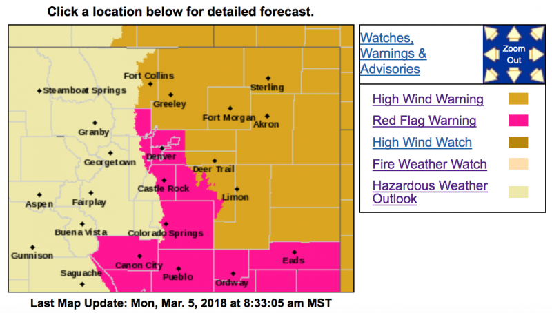
URGENT - FIRE WEATHER MESSAGE
National Weather Service Denver/Boulder CO
431 AM MST Mon Mar 5 2018
...CRITICAL FIRE WEATHER CONDITIONS TODAY...
.Despite much cooler temperatures, very strong and gusty northwest winds combined with low relative humidity will again produce extreme fire danger on the plains. The strongest winds will occur generally east of a Greeley to Denver line and extend towards Limon. Gusts up to 60 mph will be possible. Thus a Red Flag Warning remains in effect for all of the plains of Colorado.
COZ239>241-247-051945-
/O.CON.KBOU.FW.W.0007.180305T1700Z-180306T0100Z/
Boulder And Jefferson Counties Below 6000 Feet/West Broomfield
County-
North Douglas County Below 6000 Feet/Denver/West Adams and
Arapahoe Counties/East Broomfield County-
Elbert/Central and East Douglas Counties Above 6000 Feet-
Southeast Elbert County Below 6000 Feet/South Lincoln County-
431 AM MST Mon Mar 5 2018
...
RED FLAG WARNING REMAINS IN EFFECT FROM 10 AM THIS MORNING TO 6 PM MST THIS EVENING FOR WIND AND LOW RELATIVE HUMIDITY FOR THE I-25 CORRIDOR INTO THE PALMER DIVIDE...
* Affected Area...Fire Weather Zones 239...240...241 and 247.
* Timing...Late this morning through this afternoon.
* Winds...Northwest 25 to 35 mph with gusts up to 55 mph.
* Relative Humidity...As low as 10 percent.
* Impacts...Conditions will be favorable for new fire starts and rapid growth of fires. Outdoor burning is prohibited.
PRECAUTIONARY/PREPAREDNESS ACTIONS...
A Red Flag Warning means that critical fire weather conditions are either occurring now....or will shortly. A combination of strong winds...low relative humidity...and warm temperatures can contribute to extreme fire behavior.