Hazardous Weather Outlook
National Weather Service Denver/Boulder CO
1152 AM MDT Sun Apr 1 2018
COZ030>051-021800-
Jackson County Below 9000 Feet-
West Jackson and West Grand Counties Above 9000 Feet-
Grand and Summit Counties Below 9000 Feet-
South and East Jackson/Larimer/North and Northeast Grand/
Northwest Boulder Counties Above 9000 Feet-
South and Southeast Grand/West Central and Southwest Boulder/
Gilpin/Clear Creek/Summit/North and West Park Counties Above 9000 Feet-
Larimer and Boulder Counties Between 6000 and 9000 Feet-
Jefferson and West Douglas Counties Above 6000 Feet/Gilpin/Clear
Creek/Northeast Park Counties Below 9000 Feet-
Central and Southeast Park County-
Larimer County Below 6000 Feet/Northwest Weld County-
Boulder And Jefferson Counties Below 6000 Feet/West Broomfield
County-
North Douglas County Below 6000 Feet/Denver/West Adams and
Arapahoe Counties/East Broomfield County-
Elbert/Central and East Douglas Counties Above 6000 Feet-
Northeast Weld County-Central and South Weld County-Morgan County-
Central and East Adams and Arapahoe Counties-
North and Northeast Elbert County Below 6000 Feet/North Lincoln
County-
Southeast Elbert County Below 6000 Feet/South Lincoln County-
Logan County-Washington County-Sedgwick County-Phillips County-
1152 AM MDT Sun Apr 1 2018
...
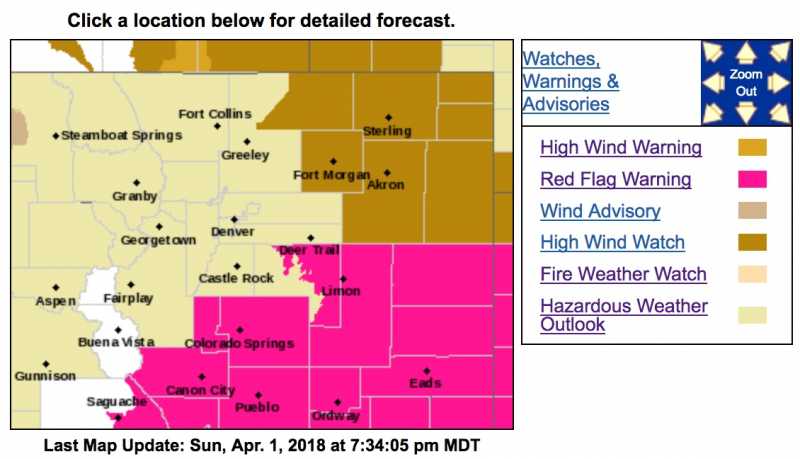
HIGH FIRE DANGER ON MONDAY EAST OF THE PALMER DIVIDE...
This hazardous weather outlook is for northeast and north central Colorado.
.DAY ONE...This Afternoon and Tonight
Light snow will be decreasing over the northern mountains through early afternoon. Otherwise skies will be clearing across the area by noon with warming temperatures.
.DAYS TWO THROUGH SEVEN...Monday through Saturday
It will be warm, dry, and windy Monday, which will increase the Fire Danger over eastern Colorado, specifically east of the Palmer Divide where west winds will gust will be as high as 40 mph with humidity near 10 percent. A cold front will push through the area Monday evening bringing a chance for light rain and snow Monday night.
.SPOTTER INFORMATION STATEMENT...
Spotter activation will not be needed today or tonight