URGENT - FIRE WEATHER MESSAGE
National Weather Service Denver/Boulder CO
344 AM MDT Tue Apr 10 2018
...FIRE DANGER INCREASES WEDNESDAY THROUGH THURSDAY...
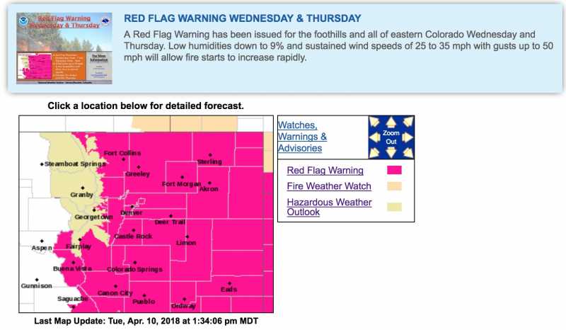
.Critical fire danger will develop across the Front Range Foothills, Park County, and all of the plains on Wednesday as warmer temperatures combine with gusty winds and very low humidities.
Fire danger may become extreme in some areas by Thursday as winds continue to strengthen in a very warm and dry airmass. The highest danger on Thursday will likely develop from South Park and the Southern Foothills across the Palmer Divide area. Critical conditions will be possible farther north, but confidence is not as high north of I-76.
COZ214-216-239>241-245>247-249-102200-
/O.NEW.KBOU.FW.W.0016.180411T1700Z-180412T0100Z/
/O.NEW.KBOU.FW.W.0017.180412T1600Z-180413T0300Z/
Central and Southeast Park County-
Jefferson and West Douglas Counties Above 6000 Feet/Gilpin/Clear
Creek/Northeast Park Counties Below 9000 Feet-
Boulder And Jefferson Counties Below 6000 Feet/West Broomfield
County-
North Douglas County Below 6000 Feet/Denver/West Adams and
Arapahoe Counties/East Broomfield County-
Elbert/Central and East Douglas Counties Above 6000 Feet-
Central and East Adams and Arapahoe Counties-
North and Northeast Elbert County Below 6000 Feet/North Lincoln
County-
Southeast Elbert County Below 6000 Feet/South Lincoln County-
Washington County-
344 AM MDT Tue Apr 10 2018
...
RED FLAG WARNING IN EFFECT FROM 11 AM TO 7 PM MDT WEDNESDAY FOR WIND AND LOW RELATIVE HUMIDITY FOR THE FRONT RANGE FOOTHILLS...SOUTH PARK...AND ALL OF THE PLAINS...
...
RED FLAG WARNING IN EFFECT FROM 10 AM TO 9 PM MDT THURSDAY FOR
WIND AND LOW RELATIVE HUMIDITY FOR SOUTH PARK...SOUTHERN FRONT
RANGE FOOTHILLS...PALMER DIVIDE...AND NEARBY ADJACENT PLAINS TO
DENVER AND AKRON...
The National Weather Service in Denver has issued a Red Flag Warning FOR WIND AND LOW RELATIVE HUMIDITY, which is in effect from 11 AM to 7 PM MDT Wednesday. A Red Flag Warning has also been issued from 10 AM to 9 PM MDT Thursday.
* Affected Area...Fire Weather Zones 214...216...239...240...241...245...246...247 and 249.
* Timing...Critical conditions are expected to develop late Wednesday morning and continue into early Wednesday evening. Extreme fire danger is expected late Thursday morning through Thursday evening.
* Winds...West 15 to 25 mph with gusts around 35 mph on Wednesday, and then Southwest winds 25 to 35 mph with gusts around 50 mph possible on Thursday. A cold front may also bring shifting winds Thursday evening.
* Relative Humidity...As low as 9 percent.
* Impacts...Conditions will be favorable for new fire starts and rapid fire growth. Extreme fire behavior is possible Thursday due to stronger winds.
PRECAUTIONARY/PREPAREDNESS ACTIONS...
A Red Flag Warning means that critical fire weather conditions are either occurring now....or will shortly. A combination of strong winds...low relative humidity...and warm temperatures can contribute to extreme fire behavior.
Hazardous Weather Outlook
National Weather Service Denver/Boulder CO
1051 AM MDT Tue Apr 10 2018
COZ030>051-111700-
Jackson County Below 9000 Feet-
West Jackson and West Grand Counties Above 9000 Feet-
Grand and Summit Counties Below 9000 Feet-
South and East Jackson/Larimer/North and Northeast Grand/
Northwest Boulder Counties Above 9000 Feet-
South and Southeast Grand/West Central and Southwest Boulder/
Gilpin/Clear Creek/Summit/North and West Park Counties Above
9000 Feet-Larimer and Boulder Counties Between 6000 and 9000 Feet-
Jefferson and West Douglas Counties Above 6000 Feet/Gilpin/Clear
Creek/Northeast Park Counties Below 9000 Feet-
Central and Southeast Park County-
Larimer County Below 6000 Feet/Northwest Weld County-
Boulder And Jefferson Counties Below 6000 Feet/West Broomfield
County-
North Douglas County Below 6000 Feet/Denver/West Adams and
Arapahoe Counties/East Broomfield County-
Elbert/Central and East Douglas Counties Above 6000 Feet-
Northeast Weld County-Central and South Weld County-Morgan County-
Central and East Adams and Arapahoe Counties-
North and Northeast Elbert County Below 6000 Feet/North Lincoln
County-
Southeast Elbert County Below 6000 Feet/South Lincoln County-
Logan County-Washington County-Sedgwick County-Phillips County-
1051 AM MDT Tue Apr 10 2018
...RED FLAG WARNING IN EFFECT 11 AM TO 7 PM MDT WEDNESDAY FOR THE
FRONT RANGE FOOTHILLS...SOUTH PARK...AND ALL OF THE PLAINS...
...RED FLAG WARNING IN EFFECT FROM 10 AM TO 9 PM MDT THURSDAY FOR
SOUTH PARK...SOUTHERN FRONT RANGE FOOTHILLS...PALMER DIVIDE...AND
NEARBY ADJACENT PLAINS TO DENVER AND AKRON...
This hazardous weather outlook is for northeast and north central Colorado.
.DAY ONE...Today and Tonight
Mild and dry conditions will prevail today.
.DAYS TWO THROUGH SEVEN...Wednesday through Monday
Fire danger will increase to critical on Wednesday with extreme conditions on Thursday. This is due to above normal temperatures, gusty winds, and low humidity levels. Extreme fire danger will likely develop over South Park, the Southern Foothills, Palmer Divide, and adjacent plains by Thursday afternoon as winds continue to strengthen with gusts between 40 and 50 mph possible.
The next storm system will move across the state Thursday night into Friday, bringing a return of rain and snow showers to the mountains, and a chance of snow and colder temperatures over the plains. Light to moderate accumulations can be expected in the mountains, with little if any accumulation across the plains. It will remain windy through Saturday before finally subsiding for Sunday and Monday.
.SPOTTER INFORMATION STATEMENT...
Spotter activation will not be needed today or tonight.