Red Flag Warning
URGENT - FIRE WEATHER MESSAGE
National Weather Service Denver/Boulder CO
409 AM MDT Thu Apr 19 2018
...VERY HIGH FIRE DANGER THIS AFTERNOON OVER PORTIONS OF THE EASTERN COLORADO PLAINS...
.Strong south to southeast winds will develop this morning across eastern Colorado. By afternoon, wind gusts of 30 to 40 mph will be common, with a few gusts as high as 50 mph possible. The winds will combine with humidities of 10-20% in areas near the mountains to produce very high to extreme fire danger. The winds will be a lighter in areas west of I-25 until late in the afternoon, so those areas will have their highest fire danger around sunset. Closer to the eastern border it will be windy but humidities will be higher. Cooler temperatures will bring higher humidities this evening, but strong winds will continue overnight and could produce dangerous fire behavior on any fires that are burning.
COZ214-216-240-241-245>247-191815-
/O.EXT.KBOU.FW.W.0019.180419T1700Z-180420T0200Z/
Central and Southeast Park County-
Jefferson and West Douglas Counties Above 6000 Feet/Gilpin/Clear Creek/Northeast Park Counties Below 9000 Feet-
North Douglas County Below 6000 Feet/Denver/West Adams and
Arapahoe Counties/East Broomfield County-
Elbert/Central and East Douglas Counties Above 6000 Feet-
Central and East Adams and Arapahoe Counties-
North and Northeast Elbert County Below 6000 Feet/North Lincoln County-
Southeast Elbert County Below 6000 Feet/South Lincoln County-
409 AM MDT Thu Apr 19 2018
...
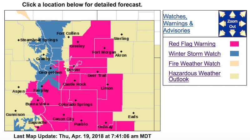
RED FLAG WARNING NOW IN EFFECT FROM 11 AM THIS MORNING TO 8 PM MDT THIS EVENING FOR WIND AND LOW RELATIVE HUMIDITY FOR SOUTH PARK...SOUTHERN FRONT RANGE FOOTHILLS...PALMER DIVIDE...DENVER...AND ADJACENT PLAINS EASTWARD THROUGH LINCOLN COUNTY...
* Affected Area...Fire Weather Zones 214...216...240...241...245...246 and 247.
* Timing...Strong winds and low humidities will develop this morning. The humidities will improve this evening, but it will remain windy overnight.
* Winds...South 25 to 35 mph with gusts up to 45 mph.
* Relative Humidity...As low as 12 percent.
* Impacts...Conditions will be favorable for new fire starts and rapid wildfire growth.
PRECAUTIONARY/PREPAREDNESS ACTIONS...
A Red Flag Warning means that critical fire weather conditions are either occurring now....or will shortly. A combination of strong winds...low relative humidity...and warm temperatures can contribute to extreme fire behavior.
Winter Storm Watch
URGENT - WINTER WEATHER MESSAGE
National Weather Service Denver CO
441 AM MDT Thu Apr 19 2018
COZ033>036-192300-
/O.NEW.KBOU.WS.A.0005.180420T1800Z-180421T1800Z/
Rocky Mountain National Park and the Medicine Bow Range-
The Mountains of Summit County, the Mosquito Range, and the Indian Peaks-
The Northern Front Range Foothills-
The Southern Front Range Foothills-
Including the cities of Cameron Pass, Laramie and Medicine Bow Mountains, Rabbit Ears Range, Rocky Mountain National Park, Willow Creek Pass,
Berthoud Pass, Breckenridge, East Slopes Mosquito Range, East Slopes Southern Gore Range, Eisenhower Tunnel, Indian Peaks, Kenosha Mountains, Mount Evans, Williams Fork Mountains, Winter Park, Estes Park, Glendevey, Nederland, Red Feather Lakes, Bailey, Central City, Evergreen, Georgetown, Idaho Springs, and Westcreek
441 AM MDT Thu Apr 19 2018
...
WINTER STORM WATCH IN EFFECT FROM FRIDAY AFTERNOON THROUGH SATURDAY MORNING...
* WHAT...
Heavy snow possible. Total snow accumulations of 8 to 14 inches, with localized amounts up to 18 inches are possible. The snow will be heaviest along the higher east facing slopes of the Front Range.
* WHERE...Rocky Mountain National Park and the Medicine Bow Range, The Mountains of Summit County, the Mosquito Range, and the Indian Peaks, The Front Range Foothills.
* WHEN...From Friday afternoon through Saturday morning.
* ADDITIONAL DETAILS...Plan on difficult travel conditions, including during the evening commute on Friday. Significant reductions in visibility are possible.
PRECAUTIONARY/PREPAREDNESS ACTIONS...
A Winter Storm Watch means there is potential for significant snow, sleet or ice accumulations that may impact travel. Continue to monitor the latest forecasts.