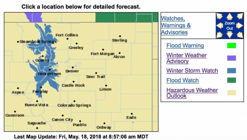
Winter Storm Watch
URGENT - WINTER WEATHER MESSAGE
National Weather Service Denver CO
348 AM MDT Fri May 18 2018
...Heavy Snow Possible tonight through Saturday...
.A slow moving and very moist spring storm will move out of the Great Basin and into northeast Colorado tonight. This system could remain relatively stationary through Saturday and result in a prolonged period of moderate to heavy snow, primarily for the mountains of western Larimer and western Boulder counties.
COZ033-034-182200-
/O.NEW.KBOU.WS.A.0007.180519T0300Z-180520T0000Z/
Rocky Mountain National Park and the Medicine Bow Range-
The Mountains of Summit County, the Mosquito Range, and the Indian Peaks-
Including the cities of Cameron Pass, Laramie and Medicine Bow Mountains, Rabbit Ears Range, Rocky Mountain National Park, Willow Creek Pass,
Berthoud Pass, Breckenridge, East Slopes Mosquito Range, East Slopes Southern Gore Range, Eisenhower Tunnel, Indian Peaks, Kenosha Mountains, Mount Evans, Williams Fork Mountains,
and Winter Park
348 AM MDT Fri May 18 2018
...WINTER STORM WATCH IN EFFECT FROM THIS EVENING THROUGH SATURDAY AFTERNOON...
* WHAT...Heavy snow possible.
Total snow accumulations of 8 to 18 inches will be possible in the mountains of western Larimer and western Boulder Counties, heaviest above 9500 feet.
* WHERE...Rocky Mountain National Park, Berthoud Pass, Cameron Pass and the Medicine Bow Range.
* WHEN...From this evening through Saturday afternoon.
* ADDITIONAL DETAILS...Plan on difficult travel conditions. Significant reductions in visibility are possible.
PRECAUTIONARY/PREPAREDNESS ACTIONS...
A Winter Storm Watch means there is potential for significant snow, sleet or ice accumulations that may impact travel. Continue to monitor the latest forecasts.
_ _ _ _ _ _ _ _ _ _ _ _ _ _ _ _ _ _ _ _ _ _ _ _ _ _ _ _ _ _ _ _ _ _ _ _ _ _ _ _
Hazardous Weather Outlook
Hazardous Weather Outlook
National Weather Service Denver/Boulder CO
429 AM MDT Fri May 18 2018
COZ030>051-191030-
Jackson County Below 9000 Feet-
West Jackson and West Grand Counties Above 9000 Feet-
Grand and Summit Counties Below 9000 Feet-
South and East Jackson/Larimer/North and Northeast Grand/
Northwest Boulder Counties Above 9000 Feet-
South and Southeast Grand/West Central and Southwest Boulder/
Gilpin/Clear Creek/Summit/North and West Park Counties Above
9000 Feet-Larimer and Boulder Counties Between 6000 and 9000 Feet-
Jefferson and West Douglas Counties Above 6000 Feet/Gilpin/Clear
Creek/Northeast Park Counties Below 9000 Feet-
Central and Southeast Park County-
Larimer County Below 6000 Feet/Northwest Weld County-
Boulder And Jefferson Counties Below 6000 Feet/West Broomfield
County-
North Douglas County Below 6000 Feet/Denver/West Adams and
Arapahoe Counties/East Broomfield County-
Elbert/Central and East Douglas Counties Above 6000 Feet-
Northeast Weld County-Central and South Weld County-Morgan County-
Central and East Adams and Arapahoe Counties-
North and Northeast Elbert County Below 6000 Feet/North Lincoln County-
Southeast Elbert County Below 6000 Feet/South Lincoln County-
Logan County-Washington County-Sedgwick County-Phillips County-
429 AM MDT Fri May 18 2018
...Heavy snow possible in the mountains of western Larimer and western Boulder counties tonight and Saturday...
...
Heavy rain and potential flooding late tonight through Saturday...
This hazardous weather outlook is for northeast and north central Colorado.
.DAY ONE...Today and Tonight
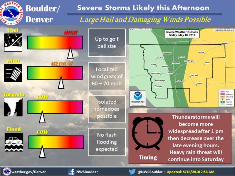
Scattered to numerous thunderstorms are expected to form in and near the foothills early to mid afternoon. These storms will progress eastward across northeast Colorado through the late afternoon and evening.
Some of the storms are expected to become severe with golf ball size hail and damaging winds. An isolated tornado can`t be ruled out as well. The best chance for severe storms will be over the plains east of Denver. However, the threat for severe storms includes the lower foothills east to the Kansas and Nebraska borders.
An area of very heavy rain may form late tonight near a developing upper level low. The location for the very heavy rain is highly uncertain at this time and may occur anywhere over northeast Colorado, southeast Wyoming, or southwest Nebraska.
.DAYS TWO THROUGH SEVEN...Saturday through Thursday
Moderate to heavy rainfall will be possible primarily north of line from around Denver to Akron on Saturday, with less intense rainfall south towards the Palmer Divide. Heavy snow potential will exist particularly in the mountains of western Larimer and western Boulder counties where the strongest northeasterly upslope will occur. In the warmer foothills of Larimer and Boulder counties, the heavy rainfall will elevate the risk of flooding.
Precipitation will gradually decrease Saturday night as a slow moving storm system starts to shift to the northeast. It will be drier on Sunday with a chance of showers and thunderstorms mainly over the higher terrain by the afternoon hours. Temperatures will be cooler this weekend, then warm up again early next week with a chance of afternoon and evening thunderstorms each day.
.SPOTTER INFORMATION STATEMENT...
Spotter activation will be needed after 1 PM today.