Your local forecasts here:
mymountaintown.com/expert-local-weather
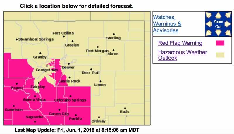
Red Flag Warning
URGENT - FIRE WEATHER MESSAGE
National Weather Service Denver/Boulder CO
329 AM MDT Fri Jun 1 2018
...WARM, DRY AND WINDY CONDITIONS FOR SOUTH PARK AND THE SOUTHERN FOOTHILLS TODAY...
.Unseasonably warm temperatures, low humidity and gusty southwesterly winds will combine with dry vegetation to bring critical fire conditions through most of the day.
COZ214-216-011730-
/O.CON.KBOU.FW.W.0026.180601T1600Z-180602T0300Z/
Central and Southeast Park County-
Jefferson and West Douglas Counties Above 6000 Feet/Gilpin/Clear
Creek/Northeast Park Counties Below 9000 Feet-
329 AM MDT Fri Jun 1 2018
...
RED FLAG WARNING REMAINS IN EFFECT FROM 10 AM THIS MORNING TO 9 PM MDT THIS EVENING FOR WIND AND LOW RELATIVE HUMIDITY FOR SOUTH PARK AND THE SOUTHERN FOOTHILLS...
* Affected Area...Fire Weather Zones 214 and 216.
* Timing...Late this morning through early this evening.
* Winds...West 10 to 20 mph with gusts up to 35 mph.
* Relative Humidity...As low as 8 percent.
* Impacts...Conditions will be favorable for the rapid growth and spread of fires.
PRECAUTIONARY/PREPAREDNESS ACTIONS...
A Red Flag Warning means that critical fire weather conditions are either occurring now....or will shortly. A combination of strong winds...low relative humidity...and warm temperatures can contribute to extreme fire behavior. Outdoor burning is discouraged. Check with local authorities on any burn bans in effect.
_________________________________________
Hazardous Weather Outlook
Hazardous Weather Outlook
National Weather Service Denver/Boulder CO
321 AM MDT Fri Jun 1 2018
COZ030>051-020930-
Jackson County Below 9000 Feet-
West Jackson and West Grand Counties Above 9000 Feet-
Grand and Summit Counties Below 9000 Feet-
South and East Jackson/Larimer/North and Northeast Grand/
Northwest Boulder Counties Above 9000 Feet-
South and Southeast Grand/West Central and Southwest Boulder/
Gilpin/Clear Creek/Summit/North and West Park Counties Above
9000 Feet-Larimer and Boulder Counties Between 6000 and 9000 Feet-
Jefferson and West Douglas Counties Above 6000 Feet/Gilpin/Clear
Creek/Northeast Park Counties Below 9000 Feet-
Central and Southeast Park County-
Larimer County Below 6000 Feet/Northwest Weld County-
Boulder And Jefferson Counties Below 6000 Feet/West Broomfield
County-
North Douglas County Below 6000 Feet/Denver/West Adams and
Arapahoe Counties/East Broomfield County-
Elbert/Central and East Douglas Counties Above 6000 Feet-
Northeast Weld County-Central and South Weld County-Morgan County-
Central and East Adams and Arapahoe Counties-
North and Northeast Elbert County Below 6000 Feet/North Lincoln
County-
Southeast Elbert County Below 6000 Feet/South Lincoln County-
Logan County-Washington County-Sedgwick County-Phillips County-
321 AM MDT Fri Jun 1 2018
...RED FLAG WARNING PARK COUNTY AND SOUTHERN FOOTHILLS LATE THIS MORNING THROUGH EARLY EVENING...
This hazardous weather outlook is for northeast and north central Colorado.
.DAY ONE...Today and Tonight
High fire danger will exist across south park and the southern foothills due to low humidity and gusty winds. Otherwise it will be dry except for a slight chance of late afternoon and early evening thunderstorms in the mountains and across the far northeast plains.
.DAYS TWO THROUGH SEVEN...Saturday through Thursday
Temperatures will peak around seasonal normals Saturday afternoon after a surge of dry and cooler air moves in from the north late tonight. On Sunday, an upper level weather disturbance will be crossing over the state, producing showers and thunderstorms over the mountains that spread onto the plains Sunday night and Monday morning. The showers are not expected to produce any hazardous weather. Dry and warmer weather are expected to return next week beneath a strong ridge of high pressure. Sub-tropical moisture increasing under the ridge late in the week will bring afternoon showers back into the forecast on Thursday.
.SPOTTER INFORMATION STATEMENT...
Spotter activation will not be needed today or tonight.