- Posts: 9766
- Thank you received: 221
- Forum
- Life Up the Hill
- Scanner & Emergency Info, Weather Forecasts
- Red Flag Warning for Sunday June 10
Red Flag Warning for Sunday June 10
- MountainTownAlerts
-
 Topic Author
- Mountain Legend
-

Less
More
09 Jun 2018 08:25 - 09 Jun 2018 12:26 #1
by MountainTownAlerts
Red Flag Warning for Sunday June 10 was created by MountainTownAlerts
The Fire Weather Watch has been upgraded to a Red Flag Warning. See next post for details.
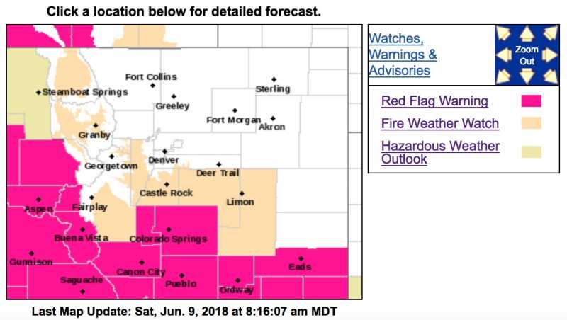
Fire Weather Watch
URGENT - FIRE WEATHER MESSAGE
National Weather Service Denver/Boulder CO
932 PM MDT Fri Jun 8 2018
...VERY WARM TEMPERATURES AND GUSTY WINDS WILL RAISE FIRE DANGER LEVELS ACROSS JACKSON, GRAND AND SUMMIT COUNTIES BELOW 9000 FEET...CENTRAL AND SOUTHEAST PARK COUNTY...PALMER DIVIDE...AND SOUTHERN RANGE FOOTHILLS ON SUNDAY...
.Warm and dry weather is expected to continue through this weekend. On Sunday, southwesterly winds are also expected to increase which will cause dangerous fire conditions to develop.
COZ211-213-091715-
/O.EXA.KBOU.FW.A.0015.180610T1600Z-180611T0100Z/
Jackson County Below 9000 Feet-
Grand and Summit Counties Below 9000 Feet-
932 PM MDT Fri Jun 8 2018
...FIRE WEATHER WATCH IN EFFECT FROM SUNDAY MORNING THROUGH SUNDAY EVENING FOR WIND AND LOW RELATIVE HUMIDITY FOR JACKSON, GRAND AND SUMMIT COUNTIES BELOW 9000 FEET...
The National Weather Service in Denver has issued a Fire Weather Watch FOR WIND AND LOW RELATIVE HUMIDITY, which is in effect from Sunday morning through Sunday evening.
* Affected Area...Fire Weather Zones 211 and 213.
* Timing...From 10 AM MDT until 7 PM MDT.
* Winds...Southwest 15 to 25 mph with gusts up to 35 mph.
* Relative Humidity...As low as 9 percent.
* Impacts...Warm temperatures, low humidities and gusty winds will cause vegetation to dry out and make dangerous fire behavior possible.
PRECAUTIONARY/PREPAREDNESS ACTIONS...
A Fire Weather Watch means that critical fire weather conditions are forecast to occur. Listen for later forecasts and possible Red Flag Warnings.
Last edit: 09 Jun 2018 12:26 by MyMountainTown.
Please Log in or Create an account to join the conversation.
- MountainTownAlerts
-
Topic Author
- Mountain Legend
-
Less
More
- Posts: 9766
- Thank you received: 221
09 Jun 2018 10:31 - 09 Jun 2018 12:21 #2
by MountainTownAlerts
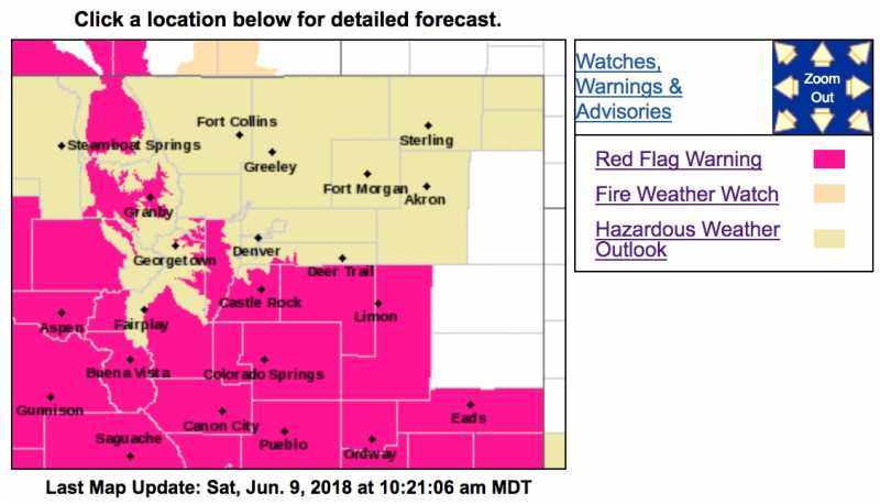
Red Flag Warning
URGENT - FIRE WEATHER MESSAGE
National Weather Service Denver/Boulder CO
900 AM MDT Sat Jun 9 2018
...VERY WARM TEMPERATURES AND GUSTY WINDS WILL BRING CRITICAL FIRE WEATHER CONDITIONS ACROSS JACKSON, GRAND AND SUMMIT COUNTIES BELOW 9000 FEET...SOUTH PARK...THE PALMER DIVIDE... AND SOUTHERN RANGE FOOTHILLS ON SUNDAY...
COZ211-213-214-216-241-246-247-092300-
/O.UPG.KBOU.FW.A.0015.180610T1600Z-180611T0100Z/
/O.NEW.KBOU.FW.W.0027.180610T1600Z-180611T0100Z/
Jackson County Below 9000 Feet-
Grand and Summit Counties Below 9000 Feet-
Central and Southeast Park County-
Jefferson and West Douglas Counties Above 6000 Feet/Gilpin/Clear
Creek/Northeast Park Counties Below 9000 Feet-
Elbert/Central and East Douglas Counties Above 6000 Feet-
North and Northeast Elbert County Below 6000 Feet/North Lincoln
County-
Southeast Elbert County Below 6000 Feet/South Lincoln County-
900 AM MDT Sat Jun 9 2018
...RED FLAG WARNING IN EFFECT FROM 10 AM TO 7 PM MDT ON SUNDAY
FOR WIND AND LOW RELATIVE HUMIDITY FOR THE HIGH MOUNTAIN VALLEYS
INCLUDING NORTH PARK...MIDDLE PARK AND SOUTH PARK...THE SOUTHERN
FOOTHILLS...THE PALMER DIVIDE AND LINCOLN COUNTY...FIRE WEATHER
ZONES 211...213...214...216...241...246 AND 247...
The National Weather Service in Denver has issued a Red Flag Warning FOR WIND AND LOW RELATIVE HUMIDITY, which is in effect from 10 AM to 7 PM MDT Sunday. The Fire Weather Watch is no longer in effect.
* Affected Area...Fire Weather Zones 211...213...214...216...
241...246 and 247.
* Timing...From 10 AM MDT until 7 PM MDT.
* Winds...Southwest 10 to 20 mph with gusts up to 35 mph.
* Relative Humidity...Poor relative humidity recoveries early Sunday morning will be followed by readings as low as 9 percent by noon.
* Impacts...Warm temperatures, low humidities and gusty winds will cause vegetation to dry out and make dangerous fire behavior possible. Rapid growth and spread of fires can be anticipated under these conditions. Outdoor burning is strongly discouraged, check with local authorities on any burn bans in effect.
PRECAUTIONARY/PREPAREDNESS ACTIONS...
A Red Flag Warning means that critical fire weather conditions are either occurring now....or will shortly. A combination of strong winds...low relative humidity...and warm temperatures can contribute to extreme fire behavior.
Replied by MountainTownAlerts on topic Red Flag Warning for Sunday June 10
Red Flag Warning
URGENT - FIRE WEATHER MESSAGE
National Weather Service Denver/Boulder CO
900 AM MDT Sat Jun 9 2018
...VERY WARM TEMPERATURES AND GUSTY WINDS WILL BRING CRITICAL FIRE WEATHER CONDITIONS ACROSS JACKSON, GRAND AND SUMMIT COUNTIES BELOW 9000 FEET...SOUTH PARK...THE PALMER DIVIDE... AND SOUTHERN RANGE FOOTHILLS ON SUNDAY...
COZ211-213-214-216-241-246-247-092300-
/O.UPG.KBOU.FW.A.0015.180610T1600Z-180611T0100Z/
/O.NEW.KBOU.FW.W.0027.180610T1600Z-180611T0100Z/
Jackson County Below 9000 Feet-
Grand and Summit Counties Below 9000 Feet-
Central and Southeast Park County-
Jefferson and West Douglas Counties Above 6000 Feet/Gilpin/Clear
Creek/Northeast Park Counties Below 9000 Feet-
Elbert/Central and East Douglas Counties Above 6000 Feet-
North and Northeast Elbert County Below 6000 Feet/North Lincoln
County-
Southeast Elbert County Below 6000 Feet/South Lincoln County-
900 AM MDT Sat Jun 9 2018
...RED FLAG WARNING IN EFFECT FROM 10 AM TO 7 PM MDT ON SUNDAY
FOR WIND AND LOW RELATIVE HUMIDITY FOR THE HIGH MOUNTAIN VALLEYS
INCLUDING NORTH PARK...MIDDLE PARK AND SOUTH PARK...THE SOUTHERN
FOOTHILLS...THE PALMER DIVIDE AND LINCOLN COUNTY...FIRE WEATHER
ZONES 211...213...214...216...241...246 AND 247...
The National Weather Service in Denver has issued a Red Flag Warning FOR WIND AND LOW RELATIVE HUMIDITY, which is in effect from 10 AM to 7 PM MDT Sunday. The Fire Weather Watch is no longer in effect.
* Affected Area...Fire Weather Zones 211...213...214...216...
241...246 and 247.
* Timing...From 10 AM MDT until 7 PM MDT.
* Winds...Southwest 10 to 20 mph with gusts up to 35 mph.
* Relative Humidity...Poor relative humidity recoveries early Sunday morning will be followed by readings as low as 9 percent by noon.
* Impacts...Warm temperatures, low humidities and gusty winds will cause vegetation to dry out and make dangerous fire behavior possible. Rapid growth and spread of fires can be anticipated under these conditions. Outdoor burning is strongly discouraged, check with local authorities on any burn bans in effect.
PRECAUTIONARY/PREPAREDNESS ACTIONS...
A Red Flag Warning means that critical fire weather conditions are either occurring now....or will shortly. A combination of strong winds...low relative humidity...and warm temperatures can contribute to extreme fire behavior.
Last edit: 09 Jun 2018 12:21 by MyMountainTown.
Please Log in or Create an account to join the conversation.
- MountainTownAlerts
-
Topic Author
- Mountain Legend
-
Less
More
- Posts: 9766
- Thank you received: 221
10 Jun 2018 09:29 #3
by MountainTownAlerts
Replied by MountainTownAlerts on topic Red Flag Warning for Sunday June 10
The time for the Red Flag Warning conditions has been extended to 10pm.
Red Flag Warning
URGENT - FIRE WEATHER MESSAGE
National Weather Service Denver/Boulder CO
332 AM MDT Sun Jun 10 2018
...VERY WARM TEMPERATURES AND GUSTY WINDS WILL BRING CRITICAL FIRE WEATHER CONDITIONS ACROSS JACKSON, GRAND AND SUMMIT COUNTIES BELOW 9000 FEET...SOUTH PARK...THE PALMER DIVIDE...AND SOUTHERN RANGE FOOTHILLS TODAY AND THIS EVENING...
COZ211-213-214-216-241-246-247-102200-
/O.CON.KBOU.FW.W.0027.180610T1600Z-180611T0400Z/
Jackson County Below 9000 Feet-
Grand and Summit Counties Below 9000 Feet-
Central and Southeast Park County-
Jefferson and West Douglas Counties Above 6000 Feet/Gilpin/Clear
Creek/Northeast Park Counties Below 9000 Feet-
Elbert/Central and East Douglas Counties Above 6000 Feet-
North and Northeast Elbert County Below 6000 Feet/North Lincoln
County-
Southeast Elbert County Below 6000 Feet/South Lincoln County-
332 AM MDT Sun Jun 10 2018
...RED FLAG WARNING REMAINS IN EFFECT FROM 10 AM THIS MORNING TO 10 PM MDT THIS EVENING FOR WIND AND LOW RELATIVE HUMIDITY FOR THE HIGH MOUNTAIN VALLEYS INCLUDING NORTH PARK...MIDDLE PARK AND SOUTH PARK...THE SOUTHERN FOOTHILLS...THE PALMER DIVIDE AND LINCOLN COUNTY...FIRE WEATHER ZONES 211...213...214...216...241...246 AND 247...
* Affected Area...Fire Weather Zones 211...213...214...216...241...246 and 247.
* Timing...From 10 AM MDT until 10 PM MDT.
* Winds...Southwest 10 to 20 mph with gusts up to 40 mph.
* Relative Humidity...As low as 5 percent.
* Impacts...Warm temperatures, low humidities and gusty winds will cause vegetation to dry out and make dangerous fire behavior possible. Rapid growth and spread of fires can be anticipated under these conditions. Outdoor burning is strongly discouraged, check with local authorities on any burn bans in effect.
PRECAUTIONARY/PREPAREDNESS ACTIONS...
A Red Flag Warning means that critical fire weather conditions are either occurring now....or will shortly. A combination of strong winds...low relative humidity...and warm temperatures can
contribute to extreme fire behavior.
Please Log in or Create an account to join the conversation.
- Forum
- Life Up the Hill
- Scanner & Emergency Info, Weather Forecasts
- Red Flag Warning for Sunday June 10
Time to create page: 0.177 seconds
sponsors


