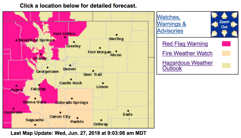
Red Flag Warning
URGENT - FIRE WEATHER MESSAGE
National Weather Service Denver/Boulder CO
339 AM MDT Wed Jun 27 2018
COZ211-213>215-217-238-271745-
/O.UPG.KBOU.FW.A.0018.180628T1700Z-180629T0300Z/
/O.NEW.KBOU.FW.W.0032.180628T1700Z-180629T0300Z/
Jackson County Below 9000 Feet-
Grand and
Summit Counties Below 9000 Feet-
Central and Southeast Park County-
Larimer and Boulder Counties Between 6000 and 9000 Feet-
West Jackson and West Grand Counties Above 9000 Feet-
Larimer County Below 6000 Feet/Northwest Weld County-
339 AM MDT Wed Jun 27 2018
...RED FLAG WARNING IN EFFECT FROM 11 AM TO 9 PM MDT THURSDAY FOR WIND AND LOW RELATIVE HUMIDITY FOR THE NORTHERN FRONT RANGE FOOTHILLS AND NEARBY PLAINS, THE PARK RANGE, AND THE HIGH MOUNTAIN VALLEYS OF NORTH CENTRAL COLORADO...
The National Weather Service in Denver has issued a
Red Flag Warning FOR WIND AND LOW RELATIVE HUMIDITY, which is in effect from 11 AM to 9 PM MDT Thursday. The Fire Weather Watch is no longer in effect.
* Affected Area...Fire Weather Zones 211...213...214...215...217 and 238.
* Timing...11 AM MDT to 9 PM MDT Thursday
* Winds...Southwest 10 to 20 mph with gusts up to 30 mph.
* Relative Humidity...As low as 8 percent.
* Impacts...Rapid fire growth and spread will be possible under these hot, dry and breezy conditions.
PRECAUTIONARY/PREPAREDNESS ACTIONS...
A Red Flag Warning means that critical fire weather conditions are either occurring now....or will shortly. A combination of strong winds...low relative humidity...and warm temperatures can contribute to extreme fire behavior.