URGENT - FIRE WEATHER MESSAGE
National Weather Service Denver/Boulder CO
414 PM MDT Wed Jun 27 2018
COZ211-213>215-217-238-281100-
/O.CON.KBOU.FW.W.0032.180628T1700Z-180629T0300Z/
Jackson County Below 9000 Feet-
Grand and Summit Counties Below 9000 Feet-
Central and Southeast Park County-
Larimer and Boulder Counties Between 6000 and 9000 Feet-
West Jackson and West Grand Counties Above 9000 Feet-
Larimer County Below 6000 Feet/Northwest Weld County-
414 PM MDT Wed Jun 27 2018
...RED FLAG WARNING REMAINS IN EFFECT FROM 11 AM TO 9 PM MDT THURSDAY FOR WIND AND LOW RELATIVE HUMIDITY FOR THE NORTHERN FRONT RANGE FOOTHILLS AND NEARBY PLAINS, THE PARK RANGE, AND THE HIGH MOUNTAIN VALLEYS OF NORTH CENTRAL COLORADO...
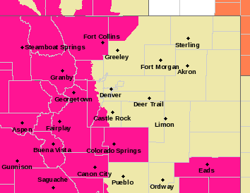
* Affected Area...Fire Weather Zones 211...213...214...215...217 and 238.
* Timing...11 AM MDT to 9 PM MDT Thursday
* Winds...Southwest 10 to 20 mph with gusts up to 30 mph.
* Relative Humidity...As low as 8 percent.
* Impacts...Rapid fire growth and spread will be possible under these hot, dry and breezy conditions.
PRECAUTIONARY/PREPAREDNESS ACTIONS...
A Red Flag Warning means that critical fire weather conditions are either occurring now....or will shortly. A combination of strong winds...low relative humidity...and warm temperatures can contribute to extreme fire behavior.
URGENT - FIRE WEATHER MESSAGE
National Weather Service Denver/Boulder CO
437 AM MDT Thu Jun 28 2018
...EXTREME FIRE DANGER IN THE MOUNTAINS TODAY...
.Very hot and very dry conditions today will combine with wind
gusts of 25 to 35 mph to produce extreme fire danger across the
northern Colorado mountains this afternoon and evening. The fire
danger will also be elevated on the plains, but the winds will not
be as strong. Conditions will not be as extreme on Friday, but
fire danger will still be very high, especially in the mountain
valleys.
Please pay attention to restrictions on fires and fireworks. Check
with your local fire department, sheriff, or land managers for
details on what is allowed.
COZ215-217-218-238-281845-
/O.EXT.KBOU.FW.W.0032.180628T1700Z-180629T0600Z/
Larimer and Boulder Counties Between 6000 and 9000 Feet-
West Jackson and West Grand Counties Above 9000 Feet-
South and East Jackson/Larimer/North and Northeast Grand/
Northwest Boulder Counties Above 9000 Feet-
Larimer County Below 6000 Feet/Northwest Weld County-
437 AM MDT Thu Jun 28 2018
...RED FLAG WARNING NOW IN EFFECT FROM 11 AM THIS MORNING TO MIDNIGHT MDT TONIGHT FOR WIND AND LOW RELATIVE HUMIDITY FOR THE MEDICINE BOW AND FRONT RANGE MOUNTAINS ABOVE 9000 FEET IN LARIMER, GRAND AND NORTHWEST BOULDER COUNTIES...
* Affected Area...Fire Weather Zones 215...217...218 and 238.
* Timing...11 AM MDT to 9 PM MDT Thursday
* Winds...Southwest 10 to 20 mph with gusts up to 35 mph.
* Relative Humidity...As low as percent.
* Impacts...Rapid fire growth and spread will be possible under
these hot, dry and breezy conditions.
PRECAUTIONARY/PREPAREDNESS ACTIONS...
A Red Flag Warning means that critical fire weather conditions are either occurring now....or will shortly. A combination of strong winds...low relative humidity...and warm temperatures can contribute to extreme fire behavior.