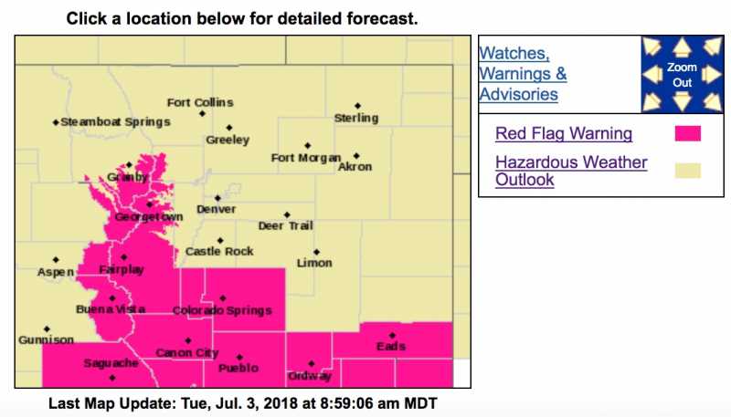
Red Flag Warning
URGENT - FIRE WEATHER MESSAGE
National Weather Service Denver/Boulder CO
403 AM MDT Tue Jul 3 2018
...STILL DRY AND BREEZY WITH A FEW THUNDERSTORMS TODAY...
.There will be a slight increase in moisture over the central Colorado mountains today, but conditions will still be warm, dry, and breezy. The added moisture will produce a few thunderstorms, most likely over and east of the Continental Divide. These storms will produce outflow wind gusts as high as 50 mph that may spread far from the parent storms. In addition, isolated dry lightning is expected this afternoon. Fire management officials should be prepared for sudden changes in the wind as well as the possibility of new fire starts this afternoon. Conditions should improve before sunset as thunderstorms move east of the area.
COZ212-214-031815-
/O.NEW.KBOU.FW.W.0035.180703T1800Z-180704T0200Z/
South and Southeast Grand/West Central and Southwest Boulder/
Gilpin/Clear Creek/Summit/North and West Park Counties Above
9000 Feet-Central and Southeast Park County-
403 AM MDT Tue Jul 3 2018
...RED FLAG WARNING IN EFFECT FROM NOON TODAY TO 8 PM MDT THIS EVENING FOR WIND...LOW RELATIVE HUMIDITY...AND ISOLATED DRY LIGHTNING FOR THE MOUNTAINS FROM BOULDER COUNTY SOUTH TO PARK COUNTY AS WELL AS SOUTH PARK...
The National Weather Service in Denver has issued a Red Flag Warning for wind, low relative humidity, and isolated dry lightning, which is in effect from noon today to 8 PM MDT this evening.
* Affected Area...Fire Weather Zones 212 and 214.
* Timing...Winds and humidities will be near Red Flag criteria from around noon until late afternoon. Thunderstorms with gusty winds and isolated dry lightning are expected between about 2 and 6 pm.
* Winds...Southwest 10 to 15 mph with gusts up to 25 mph.
* Relative Humidity...As low as 12 percent.
* Impacts...Fires will start easily and spread rapidly. New fire starts are likely. Gusty and shifting winds will cause unpredictable fire behavior, even at some distance from thunderstorms.
PRECAUTIONARY/PREPAREDNESS ACTIONS...
A Red Flag Warning means that critical fire weather conditions are either occurring now....or will shortly. A combination of strong winds...low relative humidity...and warm temperatures can
contribute to extreme fire behavior. Be prepared for changeable weather, especially gusty and shifting winds, this afternoon.