- Posts: 9766
- Thank you received: 220
- Forum
- Life Up the Hill
- Scanner & Emergency Info, Weather Forecasts
- URGENT: NWS issues Flash Flood Watch for Front Range Foothills
URGENT: NWS issues Flash Flood Watch for Front Range Foothills
- MountainTownAlerts
-
 Topic Author
- Mountain Legend
-

Less
More
05 Jul 2018 10:54 #1
by MountainTownAlerts
MMT Weather: URGENT.
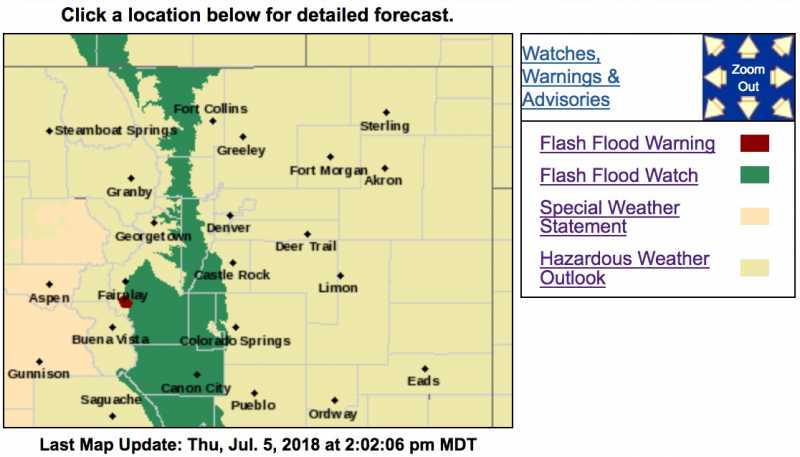
Heavy rainfall is expected this afternoon, and we want you to be aware of the dangers this poses for our area. Thunderstorms will develop over the foothills, with heavy rainfall, and the potential for flash-flooding. Please do not drive through moving water. If you live near creeks, streams or dry-washes, be aware that flash flooding is extremely dangerous. High Risk Areas: This is a potentially dangerous situation and residents in the Four Mile, High Park and Weston Pass burn areas. Monitor weather conditions for your area. We provide warnings here and on our Twitter feed. Here is an areal out line of the watch...

Take this seriously, friends. Keep a close eye on your local weather conditions, if you live near a creek, stream or dry-wash, keep an eye on water levels. This is a "Watch". Please monitor us for "Warnings" and take action to protect yourself and your property. #COwx #flashflood #Severeweather
Heavy rainfall is expected this afternoon, and we want you to be aware of the dangers this poses for our area. Thunderstorms will develop over the foothills, with heavy rainfall, and the potential for flash-flooding. Please do not drive through moving water. If you live near creeks, streams or dry-washes, be aware that flash flooding is extremely dangerous. High Risk Areas: This is a potentially dangerous situation and residents in the Four Mile, High Park and Weston Pass burn areas. Monitor weather conditions for your area. We provide warnings here and on our Twitter feed. Here is an areal out line of the watch...
Take this seriously, friends. Keep a close eye on your local weather conditions, if you live near a creek, stream or dry-wash, keep an eye on water levels. This is a "Watch". Please monitor us for "Warnings" and take action to protect yourself and your property. #COwx #flashflood #Severeweather
Please Log in or Create an account to join the conversation.
- MountainTownAlerts
-
Topic Author
- Mountain Legend
-
Less
More
- Posts: 9766
- Thank you received: 220
05 Jul 2018 11:21 #2
by MountainTownAlerts
Replied by MountainTownAlerts on topic URGENT: NWS issues Flash Flood Watch for Front Range Foothills
From the National Weather Service Denver/Boulder:
Flash Flood Watch
Flood Watch
National Weather Service Denver/Boulder CO
1016 AM MDT Thu Jul 5 2018
COZ035>037-060030-
/O.NEW.KBOU.FF.A.0003.180705T1800Z-180706T0600Z/
/00000.0.ER.000000T0000Z.000000T0000Z.000000T0000Z.OO/
Larimer and Boulder Counties Between 6000 and 9000 Feet-
Jefferson and West Douglas Counties Above 6000 Feet/Gilpin/Clear
Creek/Northeast Park Counties Below 9000 Feet-
Central and Southeast Park County-
Including the cities of Estes Park, Glendevey, Nederland,
Red Feather Lakes, Bailey, Central City, Evergreen, Georgetown,
Idaho Springs, Westcreek, Fairplay, Hartsel, Lake George,
and South Park
1016 AM MDT Thu Jul 5 2018
...FLASH FLOOD WATCH IN EFFECT THROUGH THIS EVENING...
The National Weather Service in Denver has issued a
* Flash Flood Watch for portions of Front Range Foothills and Park County, to include the fire burn areas of Four Mile, High Park and Weston Pass, which will be very susceptible to flash flooding.
* From Noon until midnight tonight
* A very moist airmass will be in place across the region with storms producing heavy rainfall of half an inch to 1 inch in an hour. These storms are expected to form over areas that have seen heavy rain in the last 24 hours or have recent fire burn areas that have low flooding thresholds.
* This is a potentially dangerous situation and residents in the Four Mile, High Park and Weston Pass burn areas should listen for later statements and possible warnings.
PRECAUTIONARY/PREPAREDNESS ACTIONS...
A Flash Flood Watch means that conditions may develop that lead to flash flooding. Flash flooding is a very dangerous situation.
You should monitor later forecasts and be prepared to take action should Flash Flood Warnings be issued.
www.weather.gov/bou/
Please Log in or Create an account to join the conversation.
- MountainTownAlerts
-
Topic Author
- Mountain Legend
-
Less
More
- Posts: 9766
- Thank you received: 220
05 Jul 2018 13:58 - 05 Jul 2018 14:07 #3
by MountainTownAlerts
Flash Flood Warning
COC093-052100-
/O.NEW.KBOU.FF.W.0007.180705T1934Z-180705T2100Z/
/00000.0.ER.000000T0000Z.000000T0000Z.000000T0000Z.OO/
BULLETIN - EAS ACTIVATION REQUESTED
Flash Flood Warning
National Weather Service Denver CO
134 PM MDT THU JUL 5 2018
The National Weather Service in Denver Colorado has issued a
* Flash Flood Warning for... Southwestern Park County in central Colorado...
* Until 300 PM MDT.
* At 132 PM MDT, Doppler radar indicated thunderstorms producing heavy rain 7 miles west of Antero Reservoir. The rain is moving northwest at 15 mph. Flash flooding is expected to begin shortly in the Weston Pass fire area.
* Flash flooding will remain over mainly rural areas of southwestern Park County, including the Weston Pass burn area and along US 285 near the fire. Excessive rainfall over the burn scar will result in debris flow. The debris flow can consist of rock, mud, vegetation and other loose materials.
Rainfall amounts of an inch in 30 minutes are possible in the warned area.
PRECAUTIONARY/PREPAREDNESS ACTIONS...
Excessive runoff from this storm will cause flash flooding of creeks and streams, roads and roadside culverts. The heavy rains could also trigger rock slides or debris flows in the Weston Pass burn area.
&&
LAT...LON 3900 10596 3899 10603 3908 10609 3912 10599 3904 10591
Replied by MountainTownAlerts on topic URGENT: NWS issues Flash Flood Watch for Front Range Foothills
Flash Flood Warning
COC093-052100-
/O.NEW.KBOU.FF.W.0007.180705T1934Z-180705T2100Z/
/00000.0.ER.000000T0000Z.000000T0000Z.000000T0000Z.OO/
BULLETIN - EAS ACTIVATION REQUESTED
Flash Flood Warning
National Weather Service Denver CO
134 PM MDT THU JUL 5 2018
The National Weather Service in Denver Colorado has issued a
* Flash Flood Warning for... Southwestern Park County in central Colorado...
* Until 300 PM MDT.
* At 132 PM MDT, Doppler radar indicated thunderstorms producing heavy rain 7 miles west of Antero Reservoir. The rain is moving northwest at 15 mph. Flash flooding is expected to begin shortly in the Weston Pass fire area.
* Flash flooding will remain over mainly rural areas of southwestern Park County, including the Weston Pass burn area and along US 285 near the fire. Excessive rainfall over the burn scar will result in debris flow. The debris flow can consist of rock, mud, vegetation and other loose materials.
Rainfall amounts of an inch in 30 minutes are possible in the warned area.
PRECAUTIONARY/PREPAREDNESS ACTIONS...
Excessive runoff from this storm will cause flash flooding of creeks and streams, roads and roadside culverts. The heavy rains could also trigger rock slides or debris flows in the Weston Pass burn area.
&&
LAT...LON 3900 10596 3899 10603 3908 10609 3912 10599 3904 10591
Last edit: 05 Jul 2018 14:07 by MountainTownAlerts. Reason: added updated weather map
Please Log in or Create an account to join the conversation.
- MountainTownAlerts
-
Topic Author
- Mountain Legend
-
Less
More
- Posts: 9766
- Thank you received: 220
05 Jul 2018 14:43 #4
by MountainTownAlerts
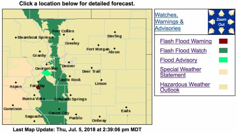
Flood Advisory
National Weather Service Denver CO
237 PM MDT THU JUL 5 2018
COC093-052200-
/O.NEW.KBOU.FA.Y.0011.180705T2037Z-180705T2200Z/
/00000.N.ER.000000T0000Z.000000T0000Z.000000T0000Z.OO/
Park CO-
237 PM MDT THU JUL 5 2018
The National Weather Service in Denver Colorado has issued a
* Small Stream Flood Advisory for... North central Park County in central Colorado...
* Until 400 PM MDT.
* At 235 PM MDT, A thunderstorm producing heavy rain was located near Mt Evans, or 34 miles west of Denver. The thunderstorm was nearly stationary. Up to two inches of rain have already fallen.
* Some locations that will experience flooding include...Grant, Kenosha Pass and Shawnee.
Additional rainfall of 0.5 to 1 inch is possible over the area in the next hour. This additional rain could result in minor flooding.
PRECAUTIONARY/PREPAREDNESS ACTIONS...
A Flood Advisory means river or stream flows are elevated, or ponding of water in urban or other areas is occurring or is imminent.
&&
LAT...LON 3938 10566 3946 10589 3956 10579 3956 10566 3944 10550
Replied by MountainTownAlerts on topic URGENT: NWS issues Flash Flood Watch for Front Range Foothills
Flood Advisory
National Weather Service Denver CO
237 PM MDT THU JUL 5 2018
COC093-052200-
/O.NEW.KBOU.FA.Y.0011.180705T2037Z-180705T2200Z/
/00000.N.ER.000000T0000Z.000000T0000Z.000000T0000Z.OO/
Park CO-
237 PM MDT THU JUL 5 2018
The National Weather Service in Denver Colorado has issued a
* Small Stream Flood Advisory for... North central Park County in central Colorado...
* Until 400 PM MDT.
* At 235 PM MDT, A thunderstorm producing heavy rain was located near Mt Evans, or 34 miles west of Denver. The thunderstorm was nearly stationary. Up to two inches of rain have already fallen.
* Some locations that will experience flooding include...Grant, Kenosha Pass and Shawnee.
Additional rainfall of 0.5 to 1 inch is possible over the area in the next hour. This additional rain could result in minor flooding.
PRECAUTIONARY/PREPAREDNESS ACTIONS...
A Flood Advisory means river or stream flows are elevated, or ponding of water in urban or other areas is occurring or is imminent.
&&
LAT...LON 3938 10566 3946 10589 3956 10579 3956 10566 3944 10550
Please Log in or Create an account to join the conversation.
- MountainTownAlerts
-
Topic Author
- Mountain Legend
-
Less
More
- Posts: 9766
- Thank you received: 220
05 Jul 2018 15:52 #5
by MountainTownAlerts
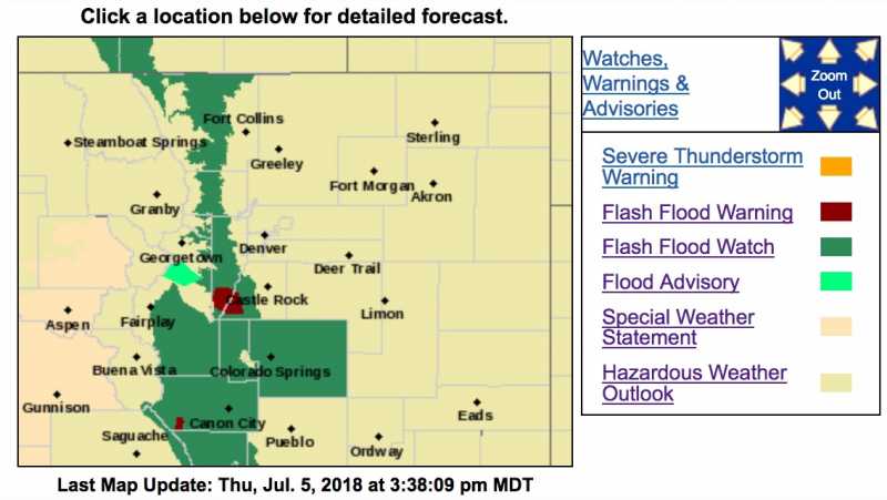
Flash Flood Warning
COC035-059-060015-
/O.NEW.KBOU.FF.W.0008.180705T2119Z-180706T0015Z/
/00000.0.ER.000000T0000Z.000000T0000Z.000000T0000Z.OO/
BULLETIN - EAS ACTIVATION REQUESTED
Flash Flood Warning
National Weather Service Denver CO
319 PM MDT THU JUL 5 2018
The National Weather Service in Denver Colorado has issued a
* Flash Flood Warning for...
Southwestern Douglas County in northeastern Colorado...
Southwestern Jefferson County in central Colorado...
* Until 615 PM MDT.
* At 314 PM MDT, Doppler radar indicated thunderstorms producing heavy rain over southern Jefferson and southwestern Douglas Counties. The storms producing the heavy rainfall are moving slowly north at 5 mph. Flash flooding is expected to begin shortly.
* Doppler radar estimates have indicated that up to 1.5 inches of rain has fallen since 2:20 PM MDT. Heavy rain is continuing.
* Some locations that will experience flooding include... Cheesman Reservoir, Wellington Lake and Deckers.
PRECAUTIONARY/PREPAREDNESS ACTIONS...
Heavy Rainfall will cause flash flooding of small creeks, streams, and ditches in the Hayman burn area. Some drainage basins affected by excessive runoff include Fourmile Creek, Goose Creek, Sixmile Creek, Trail Creek, Turkey Creek, West Creek, and other tributaries of the South Platte River. Rock slides or debris flows can also be expected across rural roads.
&&
LAT...LON 3917 10508 3916 10525 3922 10537 3930 10539 3937 10536 3938 10525 3933 10513
Replied by MountainTownAlerts on topic URGENT: NWS issues Flash Flood Watch for Front Range Foothills
Flash Flood Warning
COC035-059-060015-
/O.NEW.KBOU.FF.W.0008.180705T2119Z-180706T0015Z/
/00000.0.ER.000000T0000Z.000000T0000Z.000000T0000Z.OO/
BULLETIN - EAS ACTIVATION REQUESTED
Flash Flood Warning
National Weather Service Denver CO
319 PM MDT THU JUL 5 2018
The National Weather Service in Denver Colorado has issued a
* Flash Flood Warning for...
Southwestern Douglas County in northeastern Colorado...
Southwestern Jefferson County in central Colorado...
* Until 615 PM MDT.
* At 314 PM MDT, Doppler radar indicated thunderstorms producing heavy rain over southern Jefferson and southwestern Douglas Counties. The storms producing the heavy rainfall are moving slowly north at 5 mph. Flash flooding is expected to begin shortly.
* Doppler radar estimates have indicated that up to 1.5 inches of rain has fallen since 2:20 PM MDT. Heavy rain is continuing.
* Some locations that will experience flooding include... Cheesman Reservoir, Wellington Lake and Deckers.
PRECAUTIONARY/PREPAREDNESS ACTIONS...
Heavy Rainfall will cause flash flooding of small creeks, streams, and ditches in the Hayman burn area. Some drainage basins affected by excessive runoff include Fourmile Creek, Goose Creek, Sixmile Creek, Trail Creek, Turkey Creek, West Creek, and other tributaries of the South Platte River. Rock slides or debris flows can also be expected across rural roads.
&&
LAT...LON 3917 10508 3916 10525 3922 10537 3930 10539 3937 10536 3938 10525 3933 10513
Please Log in or Create an account to join the conversation.
- Forum
- Life Up the Hill
- Scanner & Emergency Info, Weather Forecasts
- URGENT: NWS issues Flash Flood Watch for Front Range Foothills
Time to create page: 0.253 seconds
sponsors


