URGENT - FIRE WEATHER MESSAGE
National Weather Service Denver/Boulder CO
335 PM MDT Sun Aug 26 2018
...WARM AND BREEZY WEATHER WILL INCREASE THE FIRE DANGER MONDAY...
.As warm late summer temperatures continue over northeast Colorado, a weather system approaching Colorado Monday will increase the winds across the mountains and out onto the plains. The combination of temperatures into the lower 90s, humidity levels in the lower teens and gusty winds will cause vegetation to dry out, raising fire danger levels over northeast Colorado. These conditions could lead to dangerous fire behavior if a fire were to get started. Residents are urged to be careful on Monday as any fire start could rapidly grow into a larger problem.
COZ215-216-238>246-248-249-270545-
/O.UPG.KBOU.FW.A.0020.180827T1700Z-180828T0000Z/
/O.NEW.KBOU.FW.W.0036.180827T1700Z-180828T0000Z/
Larimer and Boulder Counties Between 6000 and 9000 Feet-
Jefferson and West Douglas Counties Above 6000 Feet/Gilpin/Clear
Creek/Northeast Park Counties Below 9000 Feet-
Larimer County Below 6000 Feet/Northwest Weld County-
Boulder And Jefferson Counties Below 6000 Feet/West Broomfield
County-
North Douglas County Below 6000 Feet/Denver/West Adams and
Arapahoe Counties/East Broomfield County-
Elbert/Central and East Douglas Counties Above 6000 Feet-
Northeast Weld County-Central and South Weld County-Morgan County-
Central and East Adams and Arapahoe Counties-
North and Northeast Elbert County Below 6000 Feet/North Lincoln
County-Logan County-Washington County-
335 PM MDT Sun Aug 26 2018
...
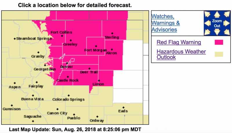
RED FLAG WARNING IN EFFECT FROM 11 AM TO 6 PM MDT MONDAY FOR WIND AND LOW RELATIVE HUMIDITY FOR THE FRONT RANGE FOOTHILLS AND NORTHEAST COLORADO PLAINS...
The National Weather Service in Denver has issued a Red Flag Warning FOR WIND AND LOW RELATIVE HUMIDITY, which is in effect from 11 AM to 6 PM MDT Monday. The Fire Weather Watch is no longer in effect.
* Affected Area...Fire Weather Zones 215...216...238...239...
240...241...242...243...244...245...246...248 and 249.
* Timing...1100 TO 1800 MDT Monday.
* Winds...West 15 to 25 mph with gusts up to 40 mph.
* Relative Humidity...As low as 10-15 percent.
* Impacts...Fires may start easily with the dry fuels and spread rapidly with anticipated gusty winds. These gusty and erratic winds may create unpredictable fire behavior.
PRECAUTIONARY/PREPAREDNESS ACTIONS...
A Red Flag Warning means that critical fire weather conditions are either occurring now....or will shortly. A combination of strong winds...low relative humidity...and warm temperatures can contribute to extreme fire behavior.