Hazardous Weather Outlook
National Weather Service Denver/Boulder CO
1014 AM MDT Fri Sep 14 2018
COZ030>051-151615-
Jackson County Below 9000 Feet-
West Jackson and West Grand Counties Above 9000 Feet-
Grand and Summit Counties Below 9000 Feet-
South and East Jackson/Larimer/North and Northeast Grand/
Northwest Boulder Counties Above 9000 Feet-
South and Southeast Grand/West Central and Southwest Boulder/
Gilpin/Clear Creek/Summit/North and West Park Counties Above
9000 Feet-Larimer and Boulder Counties Between 6000 and 9000 Feet-
Jefferson and West Douglas Counties Above 6000 Feet/Gilpin/Clear
Creek/Northeast Park Counties Below 9000 Feet-
Central and Southeast Park County-
Larimer County Below 6000 Feet/Northwest Weld County-
Boulder And Jefferson Counties Below 6000 Feet/West Broomfield
County-
North Douglas County Below 6000 Feet/Denver/West Adams and
Arapahoe Counties/East Broomfield County-
Elbert/Central and East Douglas Counties Above 6000 Feet-
Northeast Weld County-Central and South Weld County-Morgan County-
Central and East Adams and Arapahoe Counties-
North and Northeast Elbert County Below 6000 Feet/North Lincoln
County-
Southeast Elbert County Below 6000 Feet/South Lincoln County-
Logan County-Washington County-Sedgwick County-Phillips County-
1014 AM MDT Fri Sep 14 2018
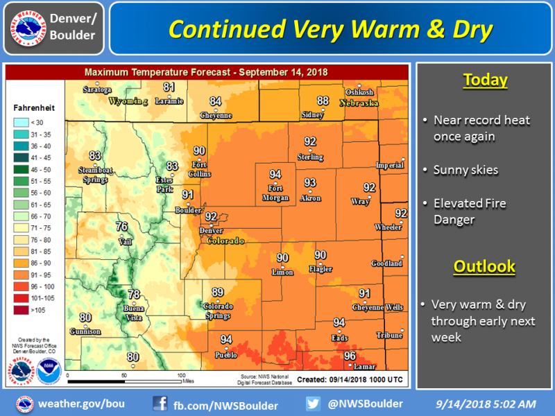
This hazardous weather outlook is for northeast and north central Colorado.
.DAY ONE...Today and Tonight
Very dry conditions and near record heat will keep the fire danger elevated today.
.DAYS TWO THROUGH SEVEN...Saturday through Thursday
Record or near record heat and dry conditions will continue this weekend, and possibly into Monday. People planning outdoor activities are reminded to stay hydrated during this abnormally hot and dry weather. Fire bans are in effect for many areas, so check ahead with local officials before heading into the backcountry. Outdoor burning of any kind is not recommended.
There may be a few degrees of cooling by Tuesday and Wednesday, but
no significant precipitation is seen through the middle part of next week.
.SPOTTER INFORMATION STATEMENT...
Spotter activation will not be needed today or tonight.
www.weather.gov/bou/