Statewide Emergency Message from CDOT:
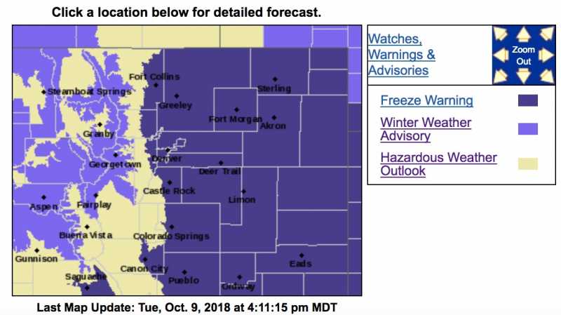
Freeze Warning - The National Weather Service has issued a
freeze warning
in effect for the Denver Metro Area and North Eastern Colorado for tonight moving into tomorrow morning. Roads may become icy in the overnight hours.
Winter Weather Advisory
URGENT - WINTER WEATHER MESSAGE
National Weather Service Denver CO
324 PM MDT Tue Oct 9 2018
COZ031-033-034-100600-
/O.NEW.KBOU.WW.Y.0027.181010T0600Z-181011T0300Z/
Rabbit Ears Pass-
Rocky Mountain National Park and the Medicine Bow Range-
The Mountains of Summit County, the Mosquito Range, and the
Indian Peaks-
Including the cities of East Slopes Park and Northern Gore
Ranges, Gore Pass, Rabbit Ears Pass, Cameron Pass,
Laramie and Medicine Bow Mountains, Rabbit Ears Range,
Rocky Mountain National Park, Willow Creek Pass,
Berthoud Pass,
Breckenridge, East Slopes Mosquito Range,
East Slopes Southern Gore Range, Eisenhower Tunnel, Indian Peaks,
Kenosha Mountains, Mount Evans, Williams Fork Mountains,
and Winter Park
324 PM MDT Tue Oct 9 2018
...
WINTER WEATHER ADVISORY IN EFFECT FROM MIDNIGHT TONIGHT TO 9 PM MDT WEDNESDAY...
* WHAT...
Snow showers this evening, but then heavier and more widespread snow late tonight through Wednesday. Total snow accumulations of 3 to 8 inches expected.
* WHERE...Rabbit Ears Pass, Rocky Mountain National Park and the Medicine Bow Range and The Mountains of Summit County, the Mosquito Range, and the Indian Peaks.
* WHEN...From midnight tonight to 9 PM MDT Wednesday.
* ADDITIONAL DETAILS...Plan on slippery road conditions. The hazardous conditions could impact travel across the Colorado mountains.
PRECAUTIONARY/PREPAREDNESS ACTIONS...
A Winter Weather Advisory for snow means periods of snow will cause primarily travel difficulties. Expect snow covered roads and limited visibilities, and use caution while driving.
The latest road conditions for the state you are calling from can be obtained by calling 5 1 1.
Freeze Warning
URGENT - WEATHER MESSAGE
National Weather Service Denver/Boulder CO
301 PM MDT Tue Oct 9 2018
COZ038>051-101600-
/O.CON.KBOU.FZ.W.0002.181010T0000Z-181010T1600Z/
Larimer County Below 6000 Feet/Northwest Weld County-
Boulder And Jefferson Counties Below 6000 Feet/West Broomfield
County-
North Douglas County Below 6000 Feet/Denver/West Adams and
Arapahoe Counties/East Broomfield County-
Elbert/Central and East Douglas Counties Above 6000 Feet-
Northeast Weld County-Central and South Weld County-Morgan County-
Central and East Adams and Arapahoe Counties-
North and Northeast Elbert County Below 6000 Feet/North Lincoln
County-
Southeast Elbert County Below 6000 Feet/South Lincoln County-
Logan County-Washington County-Sedgwick County-Phillips County-
Including the cities of Fort Collins, Hereford, Loveland, Nunn,
Arvada, Boulder, Golden, Lakewood, Longmont, Aurora, Brighton,
City of Denver, Denver International Airport, Highlands Ranch,
Littleton, Parker, Castle Rock, Elbert, Fondis, Kiowa, Larkspur,
Briggsdale, Grover, Pawnee Buttes, Raymer, Stoneham, Eaton,
Fort Lupton, Greeley, Roggen, Brush, Fort Morgan, Goodrich,
Wiggins, Bennett, Byers, Deer Trail, Leader, Agate, Hugo, Limon,
Matheson, Forder, Karval, Kutch, Punkin Center, Crook, Merino,
Sterling, Peetz, Akron, Cope, Last Chance, Otis, Julesburg, Ovid,
Sedgwick, Amherst, Haxtun, and Holyoke
301 PM MDT Tue Oct 9 2018
...
FREEZE WARNING REMAINS IN EFFECT FROM 6 PM THIS EVENING TO 10 AM MDT WEDNESDAY...
* TIMING...Temperatures should fall below 32 degrees in most areas on the plains this evening and into the mid to upper 20s by late tonight and early Wednesday morning. The coldest temperatures can be expected in areas with the least cloud cover.
* TEMPERATURE...23 to 31 degrees. The coldest temperatures can be expected in areas with the least cloud cover and up around Cheyenne Ridge and Palmer Divide. Portions of the Denver to Fort Collins corridor will be on the slightly warmer side.
* IMPACTS...Freezing temperatures could kill sensitive vegetation and damage outdoor irrigation systems and plumbing.
PRECAUTIONARY/PREPAREDNESS ACTIONS...
A Freeze Warning means sub-freezing temperatures are imminent or highly likely. These conditions will kill crops and other sensitive vegetation. Cover with layers of blankets and drain outdoor above ground sprinkler systems.