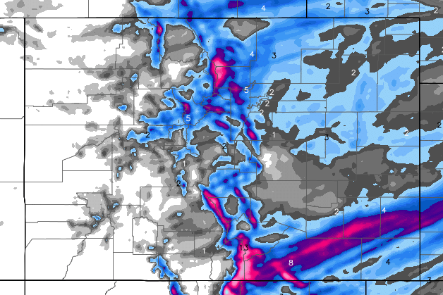
Model estimates of snowfall over the weekend for Colorado. A strong cold front will be moving through the state, late Saturday into Sunday. Temperatures will drop sharply, with Sunday's highs staying in the 20s. Along with the front, snowfall is expected for the foothills and Denver metro area. This is Hi-Res WRF-NAM model estimate for snowfall, Saturday PM through Sunday PM. Prepare for at least 2 to 4 inches for most of the foothills, with higher amounts possible. Much more in the mountains, which is excellent news. 2 to 4" possible in the Denver metro.
Our First "Real" Taste Of Winter Is On The Way...
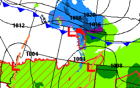
This weather depiction is for late Saturday. You can see low pressure and the cold front, which will be moving south, into Colorado. Behind that front is the coldest air of the season, so far. So, get ready for a "winter preview", with Saturday night's lows in the teens, and Sunday's highs in the teens and 20s. The colder air will wring-out any moisture in the air, so some snowfall is in our forecast. Looking at the latest models, there isn't much moisture to work with, so we are expecting fairly low accumulation, say around 2 to 4". Temperatures get warmer into next week.
Details and updates will be on our Expert Local Weather Page by Chief Meteorologist Steve Hamilton
and, as always, weather alerts, accidents, chain & traction laws, and road closures will be posted here in our Scanner & Emergency Info Forum! If you haven't already and would like to do so, Subscribe for instant email alerts of new posts.