My Mountain Town Weather Forecast October 29, 2018
Cold Front On The Way With Some Snow...
Windy and warm for the foothills to start the week. The cold front arrives Monday night/Tuesday rain and snow showers possible from Tuesday afternoon into early Wednesday. Some accumulating snow on the order of a few inches possible for the higher foothills. Minor accumulations for the mid and lower elevations. Sharply colder Tuesday night and early Wednesday. Clearing by Wednesday afternoon.
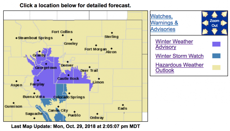
Winter Weather Advisory
URGENT - WINTER WEATHER MESSAGE
National Weather Service Denver CO
356 AM MDT Mon Oct 29 2018
...Return to Winter-like Conditions...
.
A storm system embedded in the northwest flow aloft will drop southeast across the Rockies Tuesday and Tuesday night. Snow is expected to be begin late tonight and then spread south and east Tuesday morning. The heaviest snow is expected to occur south of Interstate 70 and east of the Continental Divide Tuesday and Tuesday night. Roads are expected to become snowpacked and slippery, especially Tuesday evening when the sunsets and temperatures cool.
COZ034-292200-
/O.NEW.KBOU.WW.Y.0030.181030T1200Z-181031T1200Z/
The
Mountains of Summit County, the Mosquito Range, and the Indian Peaks-
Including the cities of Berthoud Pass, Breckenridge, East Slopes Mosquito Range, East Slopes Southern Gore Range, Eisenhower Tunnel, Indian Peaks, Kenosha Mountains, Mount Evans, Williams Fork Mountains, and Winter Park
356 AM MDT Mon Oct 29 2018
...
WINTER WEATHER ADVISORY IN EFFECT FROM 6 AM TUESDAY TO 6 AM MDT WEDNESDAY...
* WHAT...Snow expected.
Total snow accumulations of 4 to 8 inches expected over the mountains east of the Continental Divide and south of I-70. West of the Continental Divide snow will be lighter, 1 to 4 inches.
* WHERE...The Mountains of Summit County, the Mosquito Range, and the Indian Peaks.
* WHEN...From 6 AM Tuesday to 6 AM MDT Wednesday.
* ADDITIONAL DETAILS...Plan on slippery road conditions.
PRECAUTIONARY/PREPAREDNESS ACTIONS...
A Winter Weather Advisory for snow means periods of snow will cause primarily travel difficulties. Expect snow covered roads and limited visibilities, and use caution while driving.
The latest road conditions for the state you are calling from can be obtained by calling 5 1 1.
URGENT - WINTER WEATHER MESSAGE
National Weather Service Denver CO
356 AM MDT Mon Oct 29 2018
...Return to Winter-like Conditions...
.A storm system embedded in the northwest flow aloft will drop southeast across the Rockies Tuesday and Tuesday night. Snow is expected to be begin late tonight and then spread south and east Tuesday morning. The heaviest snow is expected to occur south of Interstate 70 and east of the Continental Divide Tuesday and Tuesday night. Roads are expected to become snowpacked and slippery, especially Tuesday evening when the sunsets and temperatures cool.
COZ036-037-292200-
/O.NEW.KBOU.WW.Y.0030.181030T1800Z-181031T1200Z/
The
Southern Front Range Foothills-South Park-
Including the cities of Bailey, Central City, Evergreen, Georgetown, Idaho Springs, Westcreek, Fairplay, Hartsel, Lake George, and South Park
356 AM MDT Mon Oct 29 2018
...WINTER WEATHER ADVISORY IN EFFECT FROM NOON TUESDAY TO 6 AM MDT WEDNESDAY...
* WHAT...Snow expected.
Total snow accumulations of 3 to 8 inches expected.
* WHERE...The Southern Front Range Foothills and South Park.
* WHEN...From noon Tuesday to 6 AM MDT Wednesday.
* ADDITIONAL DETAILS...
Plan on slippery road conditions.
PRECAUTIONARY/PREPAREDNESS ACTIONS...
A Winter Weather Advisory for snow means periods of snow will cause primarily travel difficulties. Expect snow covered roads and limited visibilities, and use caution while driving.
The latest road conditions for the state you are calling from can be obtained by calling 5 1 1.