URGENT - WINTER WEATHER MESSAGE
National Weather Service Denver CO
1036 AM MST Fri Nov 16 2018
...FREEZING DRIZZLE AND LIGHT SNOW WILL LIKELY IMPACT TRAVEL LATE TONIGHT INTO SATURDAY NIGHT...
.Light freezing drizzle is expected to develop across the plains later tonight and then continue into Saturday morning. The freezing drizzle will first develop along the Wyoming border shortly after midnight, and then spread southward across the plains through early Saturday morning. The precipitation will eventually mix with and change to mainly light snow from north to south on Saturday, with snow continuing into Saturday evening before ending late Saturday night. Slick roads and sidewalks can be expected late tonight into early Saturday as temperatures drop several degrees below freezing. Daylight should bring improvement to road conditions mid morning to mid/late afternoon Saturday, with a refreeze and more hazardous travel expected Saturday evening.
COZ035-036-170145-
/O.NEW.KBOU.WW.Y.0035.181117T1000Z-181118T0700Z/
The Northern Front Range Foothills-
The Southern Front Range Foothills-
Including the cities of Estes Park, Glendevey, Nederland, Red Feather Lakes, Bailey, Central City, Evergreen, Georgetown, Idaho Springs, and Westcreek
1036 AM MST Fri Nov 16 2018
...
WINTER WEATHER ADVISORY IN EFFECT FROM 3 AM SATURDAY TO MIDNIGHT MST SATURDAY NIGHT...
* WHAT...Mixed precipitation expected.
Total snow accumulations of 3 to 6 inches and ice accumulations less than one tenth of an inch expected. The heaviest snow accumulations can be expected in the foothills of Larimer and Boulder counties.
* WHERE...The Northern Front Range Foothills and The Southern Front Range Foothills.
* WHEN...From 3 AM Saturday to midnight MST Saturday night.
* ADDITIONAL DETAILS...Plan on slippery road conditions.
PRECAUTIONARY/PREPAREDNESS ACTIONS...
A Winter Weather Advisory means that periods of snow, sleet or freezing rain will cause travel difficulties. Expect slippery roads and limited visibilities, and use caution while driving.
The latest road conditions for the state you are calling from can be obtained by calling 5 1 1.
URGENT - WINTER WEATHER MESSAGE
National Weather Service Denver CO
1036 AM MST Fri Nov 16 2018
...FREEZING DRIZZLE AND LIGHT SNOW WILL LIKELY IMPACT TRAVEL LATE
TONIGHT INTO SATURDAY NIGHT...
.Light freezing drizzle is expected to develop across the plains later tonight and then continue into Saturday morning. The freezing drizzle will first develop along the Wyoming border shortly after midnight, and then spread southward across the plains through early Saturday morning. The precipitation will eventually mix with and change to mainly light snow from north to south on Saturday, with snow continuing into Saturday evening before ending late Saturday night. Slick roads and sidewalks can be expected late tonight into early Saturday as temperatures drop several degrees below freezing. Daylight should bring improvement to road conditions mid morning to mid/late afternoon Saturday, with a refreeze and more hazardous travel expected Saturday evening.
COZ038>046-048-049-170145-
/O.NEW.KBOU.WW.Y.0035.181117T1000Z-181118T0700Z/
Fort Collins-Boulder and the
western suburbs of Denver-Denver-Castle Rock-Briggsdale-Greeley-Fort Morgan-Byers-Limon-Sterling-Akron-
Including the cities of Fort Collins, Hereford, Loveland, Nunn, Arvada, Boulder,
Golden, Lakewood, Longmont, Aurora, Brighton, City of Denver, Denver International Airport, Highlands Ranch,
Littleton, Parker, Castle Rock, Elbert, Fondis, Kiowa, Larkspur, Briggsdale, Grover, Pawnee Buttes, Raymer, Stoneham, Eaton, Fort Lupton, Greeley, Roggen, Brush, Fort Morgan, Goodrich, Wiggins, Bennett, Byers, Deer Trail, Leader, Agate, Hugo, Limon, Matheson, Crook, Merino, Sterling, Peetz, Akron, Cope, Last Chance, and Otis
1036 AM MST Fri Nov 16 2018
...
WINTER WEATHER ADVISORY IN EFFECT FROM 3 AM SATURDAY TO MIDNIGHT MST SATURDAY NIGHT...
* WHAT...Mixed precipitation expected, spreading southward across the plains late tonight into early Saturday morning.
Total snow accumulations of up to two inches and ice accumulations less than one tenth of an inch expected.
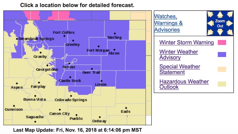
* WHERE...Portions of east central, north central and northeast Colorado, including the I-25 Corridor from the Wyoming border through Denver and the Palmer Divide.
* WHEN...From 3 AM Saturday to midnight MST Saturday night.
* ADDITIONAL DETAILS...Plan on slippery road conditions.
PRECAUTIONARY/PREPAREDNESS ACTIONS...
A Winter Weather Advisory means that periods of snow, sleet or freezing rain will cause travel difficulties. Expect slippery roads and limited visibilities, and use caution while driving.
The latest road conditions for the state you are calling from can be obtained by calling 5 1 1.