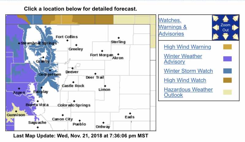
MMT Weather Urgent: Winter Storm Watch in effect for the higher foothills, including Fairplay, Jefferson, Como and Alma. A strong low pressure area will move through Colorado late Friday, with heavy snow and very gusty wind will be possible from Friday night through Saturday night. Travel may be difficult. 6 to 12 inches of snow will be possible, with wind gusts up to 60 mph. Only snow showers are in the forecast for the lower elevation foothills.
mymountaintown.com/expert-local-weather
Winter Storm Watch
URGENT - WINTER WEATHER MESSAGE
National Weather Service Denver CO
250 PM MST Wed Nov 21 2018
...SNOW AND BLOWING SNOW IN THE MOUNTAINS MAY BRING SOME HOLIDAY TRAVEL TROUBLES...
.The first light snow event will move across the northern Colorado mountains Thursday night into early Friday, but a stronger storm with more significant travel impacts is expected to arrive Friday night and continue through Saturday and Saturday night. The heaviest snow is likely to fall during the day and into the early evening hours Saturday. This second storm will bring stronger winds, heavier snow, and considerable blowing snow with poor visibilities. Persons planning to travel this holiday weekend should remain alert to the latest forecast and weather conditions, and alter plans accordingly. The weather and travel conditions through the Colorado high country are expected to improve considerably by Sunday.
COZ033-034-220700-
/O.NEW.KBOU.WS.A.0008.181124T0700Z-181125T1200Z/
Rocky Mountain National Park and the Medicine Bow Range-
The Mountains of Summit County, the Mosquito Range, and the Indian Peaks-
Including the cities of Cameron Pass,
Laramie and Medicine Bow Mountains, Rabbit Ears Range, Rocky Mountain National Park, Willow Creek Pass, Berthoud Pass,
Breckenridge, East Slopes Mosquito Range, East Slopes Southern Gore Range, Eisenhower Tunnel, Indian Peaks, Kenosha Mountains, Mount Evans, Williams Fork Mountains, and Winter Park
250 PM MST Wed Nov 21 2018
...WINTER STORM WATCH IN EFFECT FROM LATE FRIDAY NIGHT THROUGH LATE SATURDAY NIGHT...
* WHAT...Heavy snow possible.
Total snow accumulations of 6 to 12 inches possible. Winds could gust as high as 60 mph.
* WHERE...Rocky Mountain National Park and the Medicine Bow Range and The Mountains of Summit County, the Mosquito Range, and the Indian Peaks.
* WHEN...From late Friday night through late Saturday night.
* ADDITIONAL DETAILS...Travel will become hazardous. Areas of blowing snow could significantly reduce visibility. Chain or adequate snow tire laws will likely be enacted. The cold wind chills as low as 20 below zero could cause frostbite on exposed skin in as little as 30 minutes.
PRECAUTIONARY/PREPAREDNESS ACTIONS...
A Winter Storm Watch means there is potential for significant snow accumulations that may impact travel. Continue to monitor the latest forecasts