Winter Weather Warning and Advisory - Jeffco & Park County

10 Jan 2019 16:23 - 11 Jan 2019 08:31 #1 by MountainTownAlerts
Check weather page for updates and our live radar as this system arrives: mymountaintown.com/expert-local-weather


Winter Weather Advisory

URGENT - WINTER WEATHER MESSAGE
National Weather Service Denver CO
242 PM MST Thu Jan 10 2019

...SNOW MAKE A RETURN...

.An upper level weather disturbance will move into the area tonight and intensify through Friday as it moves across the state. Snow will first develop in the mountains along and south of the I-70 Corridor toward midnight tonight, and then spread across the rest of northeast and north central Colorado late tonight and Friday morning.

The main travel impacts will be in the mountains, foothills, and Palmer Divide late tonight through Friday evening, when snow covered roads and hazardous travel conditions can be expected. On the I-25 Corridor, mainly wet roads can be expected through most of Friday, but as temperatures drop Friday evening snow will start to accumulate on roads. Bridges and overpasses will be first affected. Significant winds will not occur during this snowfall.

COZ034-036-037-111200-
/O.NEW.KBOU.WW.Y.0003.190111T0700Z-190112T0700Z/
The Mountains of Summit County, the Mosquito Range, and the
Indian Peaks-The Southern Front Range Foothills-South Park-
Including the cities of Berthoud Pass, Breckenridge, East Slopes Mosquito Range, East Slopes Southern Gore Range, Eisenhower Tunnel, Indian Peaks, Kenosha Mountains, Mount Evans, Williams Fork Mountains, Winter Park, Bailey, Central City, Evergreen, Georgetown, Idaho Springs, Westcreek, Fairplay, Hartsel, Lake George, and South Park

242 PM MST Thu Jan 10 2019

...WINTER WEATHER ADVISORY IN EFFECT FROM MIDNIGHT TONIGHT TO MIDNIGHT MST FRIDAY NIGHT...

* WHAT...Snow expected. Total snow accumulations of 4 to 8 inches expected, with locally heavier amounts around 10 inches on east facing slopes. Lighter snow amounts can be expected west of the Eisenhower Tunnel.

* WHERE...The Mountains of Summit County, the Mosquito Range, and the Indian Peaks, The Southern Front Range Foothills and South Park.

* WHEN...From midnight tonight to midnight MST Friday night.

* ADDITIONAL DETAILS...Plan on slippery road conditions. The hazardous conditions could impact the Friday morning and Friday evening commute.

PRECAUTIONARY/PREPAREDNESS ACTIONS...

A Winter Weather Advisory for snow means periods of snow will cause primarily travel difficulties. Expect snow covered roads and limited visibilities, and use caution while driving.

The latest road conditions for the state you are calling from can be obtained by calling 5 1 1.
Attachments:

Please Log in or Create an account to join the conversation.

11 Jan 2019 08:34 #2 by MountainTownAlerts
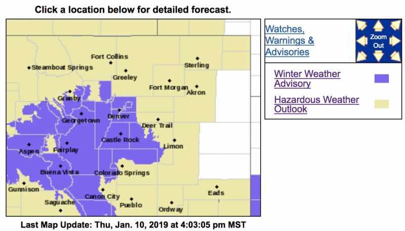
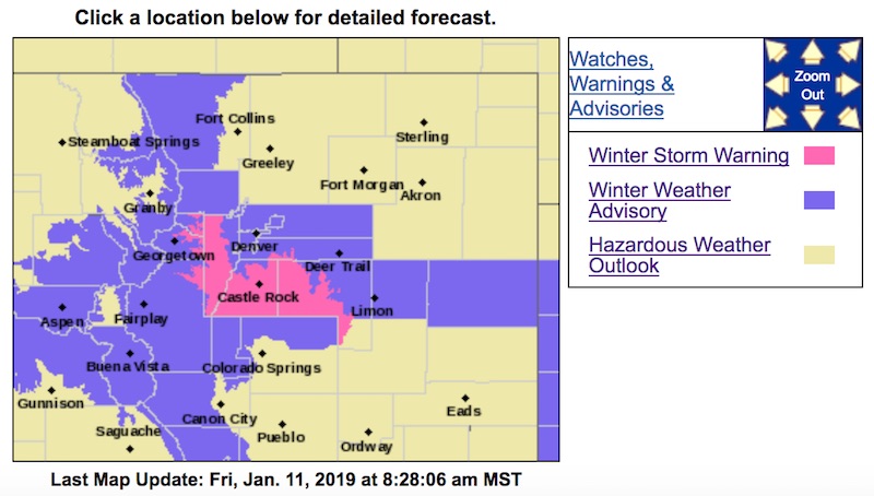
The Winter Storm Advisory has been upgraded to a Winter Storm Warning for parts of Jeffco and Park County.

URGENT - WINTER WEATHER MESSAGE
National Weather Service Denver CO
324 AM MST Fri Jan 11 2019

...SNOW MAKES A RETURN...

.An upper level weather system will move across the area today into this evening and then exit the region late tonight. Snow will continue in the mountains and spread across the plains today. The snow may be mixed with rain below 5000 feet through this afternoon.

The main travel impacts will be in the mountains, foothills, and Palmer Divide today through this evening, where snow covered roads and hazardous travel conditions can be expected. Over the the I-25 Urban Corridor, mainly wet roads can be expected through this afternoon, but as temperatures drop this evening snow will start to accumulate on roads. Bridges and overpasses will be first affected.

COZ036-111830-
/O.UPG.KBOU.WW.Y.0003.000000T0000Z-190112T0700Z/
/O.NEW.KBOU.WS.W.0001.190111T1024Z-190112T0700Z/
The Southern Front Range Foothills-
Including the cities of Bailey, Central City, Evergreen, Georgetown, Idaho Springs, and Westcreek

324 AM MST Fri Jan 11 2019

...WINTER STORM WARNING IN EFFECT UNTIL MIDNIGHT MST TONIGHT...

* WHAT...Heavy snow. Total snow accumulations of 8 to 14 inches expected.

* WHERE...The Southern Front Range Foothills.

* WHEN...Until midnight MST tonight.

* ADDITIONAL DETAILS...Travel could be very difficult. The hazardous conditions could impact the morning or evening commute.

PRECAUTIONARY/PREPAREDNESS ACTIONS...

A Winter Storm Warning for snow means severe winter weather conditions will make travel very hazardous or impossible. If you must travel, keep an extra flashlight, food and water in your vehicle in case of an emergency.

The latest road conditions for the state you are calling from can be obtained by calling 5 1 1.
Attachments:

Please Log in or Create an account to join the conversation.

Time to create page: 0.167 seconds
Powered by Kunena Forum
sponsors
© My Mountain Town (new)
Google+