Check back to
Meteorologist Steve Hamilton's weather page,
our Facebook account,
or
our Twitter account
for updates.
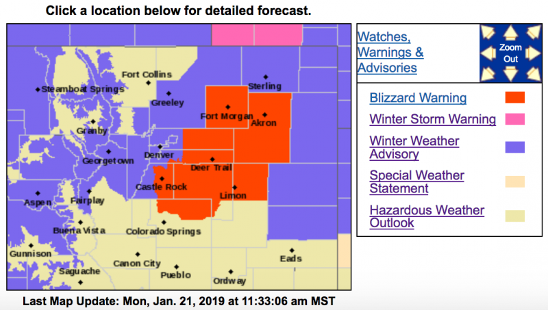
Winter Weather Advisory
URGENT - WINTER WEATHER MESSAGE
National Weather Service Denver CO
1118 AM MST Mon Jan 21 2019
...
BLIZZARD CONDITIONS EAST AND SOUTH OF DENVER TONIGHT THROUGH TUESDAY MORNING...
.A potent winter storm will move across northern Colorado. Snow, heavy at times will develop in the north central mountains late this afternoon and spread across the rest of the mountains by early evening.
Across the northeast plains, rain showers will quickly change over to snow Monday evening. Moderate to heavy snow will be possible over the northeast plains. Strong north to northwest winds will develop late this evening and continue overnight. The combination of snow and strong winds will produce blizzard conditions across the plains late tonight into Tuesday morning.
Travel through the mountains and across the northeast plains will be impacted tonight into Tuesday morning.
There is still quite a bit of uncertainty as to the exact track the main upper level low will take. Thus stay tuned for further updates on this incoming winter storm.
COZ036-220300-
/O.EXB.KBOU.WW.Y.0006.190122T0300Z-190122T1600Z/
The Southern Front Range Foothills-
Including the cities of Bailey, Central City, Evergreen, Georgetown, Idaho Springs, and Westcreek
1118 AM MST Mon Jan 21 2019
...
WINTER WEATHER ADVISORY IN EFFECT FROM 8 PM THIS EVENING TO
9 AM MST TUESDAY...
* WHAT...Snow expected.
Total snow accumulations of 4 to 8 inches expected. Winds gusting as high as 35 mph.
* WHERE...The Southern Front Range Foothills.
* WHEN...From 8 PM this evening to 9 AM MST Tuesday.
* ADDITIONAL DETAILS...Plan on slippery road conditions. Blowing snow could significantly reduce visibility. The hazardous conditions could impact the morning commute.
COZ031-033-034-220300-
/O.CON.KBOU.WW.Y.0006.190121T2200Z-190122T1600Z/
Rabbit Ears Pass-
Rocky Mountain National Park and the Medicine Bow Range-
The Mountains of Summit County, the Mosquito Range, and the Indian Peaks-
Including the cities of East Slopes Park and Northern Gore Ranges, Gore Pass, Rabbit Ears Pass, Cameron Pass, Laramie and Medicine Bow Mountains, Rabbit Ears Range, Rocky Mountain National Park, Willow Creek Pass,
Berthoud Pass, Breckenridge, East Slopes Mosquito Range, East Slopes Southern Gore Range, Eisenhower Tunnel, Indian Peaks, Kenosha Mountains, Mount Evans, Williams Fork Mountains, and Winter Park
1118 AM MST Mon Jan 21 2019
...
WINTER WEATHER ADVISORY REMAINS IN EFFECT FROM 3 PM THIS AFTERNOON TO 9 AM MST TUESDAY...
* WHAT...Snow expected.
Total snow accumulations of 4 to 10 inches expected. Winds gusting as high as 40 mph.
* WHERE...The Mountains of Summit County, the Mosquito Range, and the Indian Peaks, Rabbit Ears Pass and Rocky Mountain National Park and the Medicine Bow Range.
* WHEN...From 3 PM this afternoon to 9 AM MST Tuesday.
* ADDITIONAL DETAILS...Plan on slippery road conditions.
Patchy blowing snow could significantly reduce visibility. The hazardous conditions could impact the morning or evening commute. The cold wind chills as low as 20 below zero could cause frostbite on exposed skin in as little as 30 minutes.
PRECAUTIONARY/PREPAREDNESS ACTIONS...
A Winter Weather Advisory for snow means periods of snow will cause primarily travel difficulties. Expect snow covered roads and limited visibilities, and use caution while driving.
The latest road conditions for the state you are calling from can be obtained by calling 5 1 1.
__________________________________________________________________________
URGENT - WINTER WEATHER MESSAGE
National Weather Service Denver CO
1118 AM MST Mon Jan 21 2019
...BLIZZARD CONDITIONS EAST AND SOUTH OF DENVER TONIGHT THROUGH
TUESDAY MORNING...
.A potent winter storm will move across northern Colorado. Snow, heavy at times will develop in the north central mountains late this afternoon and spread across the rest of the mountains by early evening.
Across the northeast plains, rain showers will quickly change over to snow Monday evening. Moderate to heavy snow will be possible over the northeast plains. Strong north to northwest winds will develop late this evening and continue overnight. The combination of snow and strong winds will produce blizzard conditions across the plains late tonight into Tuesday morning.
Travel through the mountains and across the northeast plains will be impacted tonight into Tuesday morning.
There is still quite a bit of uncertainty as to the exact track the main upper level low will take. Thus stay tuned for further updates on this incoming winter storm.
COZ039-040-043-220300-
/O.EXB.KBOU.WW.Y.0006.190122T0300Z-190122T1600Z/
Boulder and the western suburbs of Denver-Denver-Greeley-
Including the cities of Arvada, Boulder, Golden, Lakewood, Longmont, Aurora, Brighton, City of Denver, Denver International Airport, Highlands Ranch, Littleton, Parker, Eaton, Fort Lupton, Greeley, and Roggen
1118 AM MST Mon Jan 21 2019
...
WINTER WEATHER ADVISORY IN EFFECT FROM 8 PM THIS EVENING TO 9 AM MST TUESDAY...
* WHAT...Snow expected.
Total snow accumulations of 2 to 6 inches expected. Winds gusting as high as 40 mph.
* WHERE...Boulder and the western suburbs of Denver, Denver and Greeley.
* WHEN...From 8 PM this evening to 9 AM MST Tuesday.
* ADDITIONAL DETAILS...Plan on slippery road conditions. Blowing snow could significantly reduce visibility, especially east of Interstate 25. The hazardous conditions could impact the morning commute.
PRECAUTIONARY/PREPAREDNESS ACTIONS...
A Winter Weather Advisory for snow means periods of snow will cause primarily travel difficulties. Expect snow covered roads and limited visibilities, and use caution while driving.
The latest road conditions for the state you are calling from can be obtained by calling 5 1 1.