- Posts: 9766
- Thank you received: 221
- Forum
- Life Up the Hill
- Scanner & Emergency Info, Weather Forecasts
- Winter Weather Warning and Advisory - Jeffco & Park County Feb 28
Winter Weather Warning and Advisory - Jeffco & Park County Feb 28
- MountainTownAlerts
-
 Topic Author
- Mountain Legend
-

Less
More
28 Feb 2019 22:13 #1
by MountainTownAlerts
From Steve Hamilton:
Winter Storm Watch / Warning For The Foothills...
A Winter Storm Watch is posted from Saturday morning through late Saturday Night. Meanwhile, a Winter Storm Warning is up for Fairplay, Alma, Como and Jefferson until 5 a.m. Sunday. An Arctic cold front will move into eastern Colorado on Friday, followed by very cold air. We'll start off with some snow showers Friday, with just minor accumulation. It is likely we'll get period of significant upslope flow from Saturday through early Sunday. 3 to 5 inches of accumulation will be possible. Heavy snow will be possible for most areas Saturday night. More specific updates on accumulation will be posted Friday. Meantime, prepare for winter driving conditons and significant snowfall.
mymountaintown.com/expert-local-weather
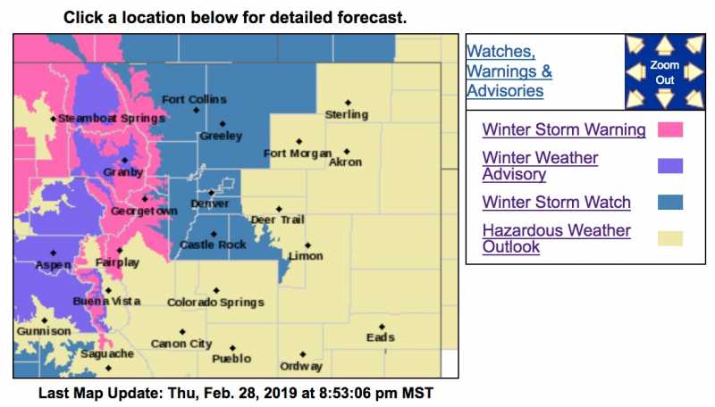
Winter Storm Warning
URGENT - WINTER WEATHER MESSAGE
National Weather Service Denver CO
533 PM MST Thu Feb 28 2019
...HEAVY SNOW FOR THE NORTHERN MOUNTAINS TONIGHT THROUGH SATURDAY...
...SNOW AND COLD RETURN TO THE FRONT RANGE FRIDAY NIGHT AND THROUGH THE WEEKEND...
.Moisture embedded in zonal flow aloft will move across Colorado tonight through Saturday night. Periods of heavy snow will occur at times. In the mountains, 14 to 36 inches of accumulation will be possible with locally up to 48 inches by late Saturday evening. Winds gusting up to 45 mph at times will produce areas of blowing snow and poor visibilities. A moist Pacific jet stream combined with an arctic cold front will bring snow to the Front Range and eastern plains beginning Friday night and continuing through Saturday night.
COZ031-033-034-010845-
/O.EXT.KBOU.WS.W.0005.000000T0000Z-190303T1200Z/
Rabbit Ears Pass-
Rocky Mountain National Park and the Medicine Bow Range-
The Mountains of Summit County, the Mosquito Range, and the Indian Peaks-
Including the cities of East Slopes Park and Northern Gore Ranges, Gore Pass, Rabbit Ears Pass, Cameron Pass, Laramie and Medicine Bow Mountains, Rabbit Ears Range, Rocky Mountain National Park, Willow Creek Pass, Berthoud Pass, Breckenridge, East Slopes Mosquito Range, East Slopes Southern Gore Range, Eisenhower Tunnel, Indian Peaks, Kenosha Mountains, Mount Evans, Williams Fork Mountains, and Winter Park
533 PM MST Thu Feb 28 2019
...WINTER STORM WARNING NOW IN EFFECT UNTIL 5 AM MST SUNDAY...
* WHAT...Heavy snow expected. Total snow accumulations of 14 to 28 inches expected. Up to 36 inches possible over northern mountains. Winds gusting as high as 45 mph.
* WHERE...The Mountains of Summit County, the Mosquito Range, and the Indian Peaks.
* WHEN...Until 5 AM MST Sunday.
* ADDITIONAL DETAILS...Travel could be very difficult to impossible. The hazardous conditions could impact the morning or evening commute.
PRECAUTIONARY/PREPAREDNESS ACTIONS...
A Winter Storm Warning for snow means severe winter weather conditions will make travel very hazardous or impossible. If you must travel, keep an extra flashlight, food and water in your vehicle in case of an emergency.
The latest road conditions for the state you are calling from can be obtained by calling 5 1 1.
* * * * * * * * * * * * * * * * * * * * * * * * * * * * * * * * * * * * * * * * * * * * * * * * * * * * * * * * * * * * * *
Winter Weather Advisory
URGENT - WINTER WEATHER MESSAGE
National Weather Service Denver CO
533 PM MST Thu Feb 28 2019
...HEAVY SNOW FOR THE NORTHERN MOUNTAINS TONIGHT THROUGH SATURDAY...
...SNOW AND COLD RETURN TO THE FRONT RANGE FRIDAY NIGHT AND THROUGH THE WEEKEND...
.Moisture embedded in zonal flow aloft will move across Colorado tonight through Saturday night. Periods of heavy snow will occur at times. In the mountains, 14 to 36 inches of accumulation will be possible with locally up to 48 inches by late Saturday evening. Winds gusting up to 45 mph at times will produce areas of blowing snow and poor visibilities. A moist Pacific jet stream combined with an arctic cold front will bring snow to the Front Range and eastern plains beginning Friday night and continuing through Saturday night.
COZ030-032-010845-
/O.NEW.KBOU.WW.Y.0015.190301T0033Z-190303T1200Z/
North Park-Grand and Summit Counties Below 9000 Feet-
Including the cities of Gould, North Park, Rand, Spicer, Walden, Dillon, Fraser, Granby, Grand Lake, Hot Sulphur Springs, and Kremmling
533 PM MST Thu Feb 28 2019
...WINTER WEATHER ADVISORY IN EFFECT UNTIL 5 AM MST SUNDAY...
* WHAT...Snow. Additional snow accumulations of 6 to 12 inches.
* WHERE...North Park and Grand and Summit Counties Below 9000 Feet.
* WHEN...Until 5 AM MST Sunday.
* ADDITIONAL DETAILS...Travel could be very difficult. The hazardous conditions could impact the morning or evening commute.
PRECAUTIONARY/PREPAREDNESS ACTIONS...
A Winter Weather Advisory for snow means periods of snow will cause primarily travel difficulties. Expect snow covered roads and limited visibilities, and use caution while driving.
The latest road conditions for the state you are calling from can be obtained by calling 5 1 1.
Winter Storm Watch / Warning For The Foothills...
A Winter Storm Watch is posted from Saturday morning through late Saturday Night. Meanwhile, a Winter Storm Warning is up for Fairplay, Alma, Como and Jefferson until 5 a.m. Sunday. An Arctic cold front will move into eastern Colorado on Friday, followed by very cold air. We'll start off with some snow showers Friday, with just minor accumulation. It is likely we'll get period of significant upslope flow from Saturday through early Sunday. 3 to 5 inches of accumulation will be possible. Heavy snow will be possible for most areas Saturday night. More specific updates on accumulation will be posted Friday. Meantime, prepare for winter driving conditons and significant snowfall.
mymountaintown.com/expert-local-weather
Winter Storm Warning
URGENT - WINTER WEATHER MESSAGE
National Weather Service Denver CO
533 PM MST Thu Feb 28 2019
...HEAVY SNOW FOR THE NORTHERN MOUNTAINS TONIGHT THROUGH SATURDAY...
...SNOW AND COLD RETURN TO THE FRONT RANGE FRIDAY NIGHT AND THROUGH THE WEEKEND...
.Moisture embedded in zonal flow aloft will move across Colorado tonight through Saturday night. Periods of heavy snow will occur at times. In the mountains, 14 to 36 inches of accumulation will be possible with locally up to 48 inches by late Saturday evening. Winds gusting up to 45 mph at times will produce areas of blowing snow and poor visibilities. A moist Pacific jet stream combined with an arctic cold front will bring snow to the Front Range and eastern plains beginning Friday night and continuing through Saturday night.
COZ031-033-034-010845-
/O.EXT.KBOU.WS.W.0005.000000T0000Z-190303T1200Z/
Rabbit Ears Pass-
Rocky Mountain National Park and the Medicine Bow Range-
The Mountains of Summit County, the Mosquito Range, and the Indian Peaks-
Including the cities of East Slopes Park and Northern Gore Ranges, Gore Pass, Rabbit Ears Pass, Cameron Pass, Laramie and Medicine Bow Mountains, Rabbit Ears Range, Rocky Mountain National Park, Willow Creek Pass, Berthoud Pass, Breckenridge, East Slopes Mosquito Range, East Slopes Southern Gore Range, Eisenhower Tunnel, Indian Peaks, Kenosha Mountains, Mount Evans, Williams Fork Mountains, and Winter Park
533 PM MST Thu Feb 28 2019
...WINTER STORM WARNING NOW IN EFFECT UNTIL 5 AM MST SUNDAY...
* WHAT...Heavy snow expected. Total snow accumulations of 14 to 28 inches expected. Up to 36 inches possible over northern mountains. Winds gusting as high as 45 mph.
* WHERE...The Mountains of Summit County, the Mosquito Range, and the Indian Peaks.
* WHEN...Until 5 AM MST Sunday.
* ADDITIONAL DETAILS...Travel could be very difficult to impossible. The hazardous conditions could impact the morning or evening commute.
PRECAUTIONARY/PREPAREDNESS ACTIONS...
A Winter Storm Warning for snow means severe winter weather conditions will make travel very hazardous or impossible. If you must travel, keep an extra flashlight, food and water in your vehicle in case of an emergency.
The latest road conditions for the state you are calling from can be obtained by calling 5 1 1.
* * * * * * * * * * * * * * * * * * * * * * * * * * * * * * * * * * * * * * * * * * * * * * * * * * * * * * * * * * * * * *
Winter Weather Advisory
URGENT - WINTER WEATHER MESSAGE
National Weather Service Denver CO
533 PM MST Thu Feb 28 2019
...HEAVY SNOW FOR THE NORTHERN MOUNTAINS TONIGHT THROUGH SATURDAY...
...SNOW AND COLD RETURN TO THE FRONT RANGE FRIDAY NIGHT AND THROUGH THE WEEKEND...
.Moisture embedded in zonal flow aloft will move across Colorado tonight through Saturday night. Periods of heavy snow will occur at times. In the mountains, 14 to 36 inches of accumulation will be possible with locally up to 48 inches by late Saturday evening. Winds gusting up to 45 mph at times will produce areas of blowing snow and poor visibilities. A moist Pacific jet stream combined with an arctic cold front will bring snow to the Front Range and eastern plains beginning Friday night and continuing through Saturday night.
COZ030-032-010845-
/O.NEW.KBOU.WW.Y.0015.190301T0033Z-190303T1200Z/
North Park-Grand and Summit Counties Below 9000 Feet-
Including the cities of Gould, North Park, Rand, Spicer, Walden, Dillon, Fraser, Granby, Grand Lake, Hot Sulphur Springs, and Kremmling
533 PM MST Thu Feb 28 2019
...WINTER WEATHER ADVISORY IN EFFECT UNTIL 5 AM MST SUNDAY...
* WHAT...Snow. Additional snow accumulations of 6 to 12 inches.
* WHERE...North Park and Grand and Summit Counties Below 9000 Feet.
* WHEN...Until 5 AM MST Sunday.
* ADDITIONAL DETAILS...Travel could be very difficult. The hazardous conditions could impact the morning or evening commute.
PRECAUTIONARY/PREPAREDNESS ACTIONS...
A Winter Weather Advisory for snow means periods of snow will cause primarily travel difficulties. Expect snow covered roads and limited visibilities, and use caution while driving.
The latest road conditions for the state you are calling from can be obtained by calling 5 1 1.
Please Log in or Create an account to join the conversation.
- MountainTownAlerts
-
Topic Author
- Mountain Legend
-
Less
More
- Posts: 9766
- Thank you received: 221
01 Mar 2019 12:00 #2
by MountainTownAlerts
Replied by MountainTownAlerts on topic Winter Weather Warning and Advisory - Jeffco & Park County Feb 28
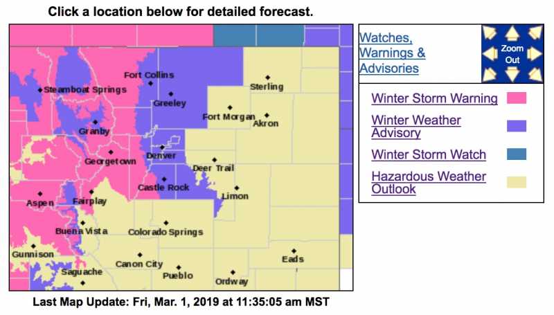
Updated - the Winter Storm Warning now covers parts of Jefferson County and lasts through Sunday morning.
Winter Storm Warning
URGENT - WINTER WEATHER MESSAGE
National Weather Service Denver CO
1031 AM MST Fri Mar 1 2019
...HEAVY SNOW FOR THE NORTHERN MOUNTAINS INTO SUNDAY MORNING...
...SNOW AND COLD RETURN TO THE FRONT RANGE TONIGHT THROUGH THE WEEKEND...
.Moisture embedded in zonal flow aloft will move across Colorado into Sunday. Periods of heavy snow will occur at times. In the mountains, 15 to 30 inches of accumulation will be possible with isolated amounts up to 40 inches by Sunday morning. Winds gusting up to 45 mph at times will produce areas of blowing snow and poor visibilities. A moist Pacific jet stream combined with an arctic cold front will bring snow to the Front Range and eastern plains beginning tonight and continuing through Sunday morning.
COZ036-020145-
/O.UPG.KBOU.WS.A.0004.190302T1600Z-190303T1200Z/
/O.EXB.KBOU.WS.W.0005.190302T1600Z-190303T1800Z/
The Southern Front Range Foothills-
Including the cities of Bailey, Central City, Evergreen, Georgetown, Idaho Springs, and Westcreek
1031 AM MST Fri Mar 1 2019
...WINTER STORM WARNING IN EFFECT FROM 9 AM SATURDAY TO 11 AM MST SUNDAY...
* WHAT...Heavy snow expected. Total snow accumulations of 6 to 12 inches expected.
* WHERE...The Southern Front Range Foothills.
* WHEN...From 9 AM Saturday to 11 AM MST Sunday.
* ADDITIONAL DETAILS...Plan on slippery road conditions.
PRECAUTIONARY/PREPAREDNESS ACTIONS...
A Winter Storm Warning for snow means severe winter weather conditions will make travel very hazardous or impossible. If you must travel, keep an extra flashlight, food and water in your vehicle in case of an emergency.
The latest road conditions for the state you are calling from can be obtained by calling 5 1 1.
* * * * * * * * * * * * * * * * * * * * * * * * * * * * * * * * * * * * * * * * * * * * * * * * * * * * * * * * * * * * * * * * * *
URGENT - WINTER WEATHER MESSAGE
National Weather Service Denver CO
1031 AM MST Fri Mar 1 2019
...HEAVY SNOW FOR THE NORTHERN MOUNTAINS INTO SUNDAY MORNING...
...SNOW AND COLD RETURN TO THE FRONT RANGE TONIGHT THROUGH THE WEEKEND...
.Moisture embedded in zonal flow aloft will move across Colorado into Sunday. Periods of heavy snow will occur at times. In the mountains, 15 to 30 inches of accumulation will be possible with isolated amounts up to 40 inches by Sunday morning. Winds gusting up to 45 mph at times will produce areas of blowing snow and poor visibilities. A moist Pacific jet stream combined with an arctic cold front will bring snow to the Front Range and eastern plains beginning tonight and continuing through Sunday morning.
COZ031-033-034-020145-
/O.EXT.KBOU.WS.W.0005.000000T0000Z-190303T1800Z/
Rabbit Ears Pass-
Rocky Mountain National Park and the Medicine Bow Range-
The Mountains of Summit County, the Mosquito Range, and the Indian Peaks-
Including the cities of East Slopes Park and Northern Gore Ranges, Gore Pass, Rabbit Ears Pass, Cameron Pass, Laramie and Medicine Bow Mountains, Rabbit Ears Range, Rocky Mountain National Park, Willow Creek Pass, Berthoud Pass, Breckenridge, East Slopes Mosquito Range, East Slopes Southern Gore Range, Eisenhower Tunnel, Indian Peaks, Kenosha Mountains, Mount Evans, Williams Fork Mountains, and Winter Park
1031 AM MST Fri Mar 1 2019
...WINTER STORM WARNING NOW IN EFFECT UNTIL 11 AM MST SUNDAY...
* WHAT...Heavy snow expected. Total snow accumulations of 15 to 30 inches expected. Up to 40 inches possible in the northern mountains. Winds gusting as high as 45 mph.
* WHERE...The Mountains of Summit County, the Mosquito Range, and the Indian Peaks.
* WHEN...Until 11 AM MST Sunday.
* ADDITIONAL DETAILS...Travel could be very difficult to impossible. The hazardous conditions could impact the morning or evening commute.
PRECAUTIONARY/PREPAREDNESS ACTIONS...
A Winter Storm Warning means significant amounts of snow, sleet and ice will make travel very hazardous or impossible.
The latest road conditions for the state you are calling from can be obtained by calling 5 1 1.
Please Log in or Create an account to join the conversation.
- Forum
- Life Up the Hill
- Scanner & Emergency Info, Weather Forecasts
- Winter Weather Warning and Advisory - Jeffco & Park County Feb 28
Time to create page: 0.153 seconds
sponsors


