From
our Chief Meteorologist Steve Hamilton:
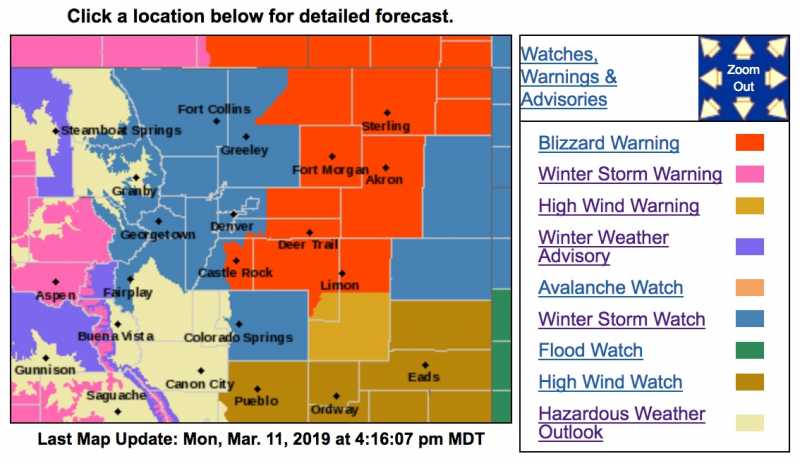
Possible Snow-Maker On The Way...
We'll have a few scattered rain and snow showers around the foothills Monday from a low pressure trough over the central mountains. Temperatures will be fairly mild. Tuesday looks fair, with just slight precipitation chances. The big focus is a strong storm which is forecast to move to our south on Wednesday. Models are showing a powerful low pressure area developing over the Great Basin before heading east. Impact for the foothills looks to be minimal, with just a few inches and gusty wind, while blizzard conditions will be possible on the northeast plains. As usual, snowfall will depend on the storm track, as well as available moisture and wind direction over our region, and we may end up with a decent snowfall Wednesday into Wednesday night. Stay tuned...
Winter Storm Watch
URGENT - WINTER WEATHER MESSAGE
National Weather Service Denver CO
324 PM MDT Mon Mar 11 2019
...Blizzard expected to develop over portions of northeast Colorado Wednesday afternoon and Wednesday night...
.Heavy snow and very strong winds will develop over most of northeast Colorado Wednesday afternoon and Wednesday night. The most severe conditions are likely to develop just east of the I-25 Corridor where the heaviest snow is expected to fall. Power outages and wind damage will also be possible as winds gust to between 60 and 70 mph.
Further west along the I-25 Urban Corridor, heavy snow and gusty winds will also be possible, with significant travel impacts. Rain is expected to develop Tuesday night, and then change to snow Wednesday morning and may become heavy at times.
Mountain areas will also see more accumulating snowfall during this period.
A powerful storm system will move into southeast Colorado or southwest Kansas by Wednesday morning, and then track slowly northeast into southwest Nebraska by Wednesday night. Meanwhile surface low pressure will intensify rapidly over southeast Colorado, producing the very strong winds and heavy snowfall. Stay tuned to the National Weather Service for the latest Watches and Warnings.
COZ036-039-120530-
/O.EXA.KBOU.WS.A.0006.190313T1800Z-190314T0600Z/
The Southern Front Range Foothills-
Boulder and the western suburbs of Denver-
Including the cities of Bailey, Central City, Evergreen, Georgetown, Idaho Springs, Westcreek, Arvada, Boulder, Golden, Lakewood, and Longmont
324 PM MDT Mon Mar 11 2019
...
WINTER STORM WATCH IN EFFECT FROM WEDNESDAY AFTERNOON THROUGH WEDNESDAY EVENING...
* WHAT...
Heavy snow possible. Total snow accumulations of 4 to 8 inches possible. Winds could gust as high as 45 mph.
* WHERE...The Southern Front Range Foothills and Boulder and the western suburbs of Denver.
* WHEN...From Wednesday afternoon through Wednesday evening.
* ADDITIONAL DETAILS...Plan on slippery road conditions. Patchy blowing snow could significantly reduce visibility. The hazardous conditions could impact the afternoon and evening commute with rapidly deteriorating conditions by midday Wednesday.
PRECAUTIONARY/PREPAREDNESS ACTIONS...
A Winter Storm Watch means there is potential for significant snow, sleet or ice accumulations that may impact travel. Continue to monitor the latest forecasts.
* * * * * * * * * * * * * * * * * * * * * * * * * * * * * * * * * * * * * * * * * * * * * * * * * * * * * * * * * * * * * * * * * * * * * *
URGENT - WINTER WEATHER MESSAGE
National Weather Service Denver CO
324 PM MDT Mon Mar 11 2019
COZ034-120530-
/O.EXA.KBOU.WS.A.0006.190313T0600Z-190314T0600Z/
The Mountains of Summit County, the Mosquito Range, and the Indian Peaks-
Including the cities of Berthoud Pass, Breckenridge, East Slopes Mosquito Range, East Slopes Southern Gore Range, Eisenhower Tunnel, Indian Peaks, Kenosha Mountains, Mount Evans, Williams Fork Mountains, and Winter Park
324 PM MDT Mon Mar 11 2019
...
WINTER STORM WATCH IN EFFECT FROM LATE TUESDAY NIGHT THROUGH WEDNESDAY EVENING...
* WHAT...
Heavy snow possible. Total snow accumulations of 8 to 14 inches possible. Winds could gust as high as 35 mph.
* WHERE...The Mountains of Summit County, the Mosquito Range, and the Indian Peaks.
* WHEN...From late Tuesday night through Wednesday evening.
* ADDITIONAL DETAILS...Travel could be very difficult. Areas of blowing snow could significantly reduce visibility. The cold wind chills as low as 20 below zero could cause frostbite on exposed skin in as little as 30 minutes.
PRECAUTIONARY/PREPAREDNESS ACTIONS...
A Winter Storm Watch means there is potential for significant snow, sleet or ice accumulations that may impact travel. Continue to monitor the latest forecasts.