Winter Storm Warning
URGENT - WINTER WEATHER MESSAGE...CORRECTED
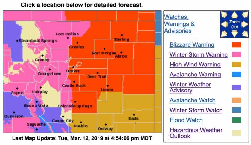
National Weather Service Denver CO
1055 AM MDT Tue Mar 12 2019
...Blizzard expected to develop over portions of northeast Colorado Wednesday afternoon and Wednesday night...
.Heavy snow and very strong winds will develop over most of northeast Colorado Wednesday afternoon and Wednesday night. Blizzard conditions are likely to develop along and east of the I- 25 Corridor where the heaviest snow is expected to fall. Power outages and wind damage will also be possible as winds gust to between 60 and 70 mph will be possible.
West of the I-25 Urban Corridor, heavy snow and gusty winds will also be possible, with significant travel impacts. Rain is expected to develop Tuesday night, and then change to snow late Wednesday morning and may become heavy at times with wind gusts from 40 to 60 mph.
Mountain areas will also see more accumulating snowfall during this period.
COZ036-038-039-130045-
/O.UPG.KBOU.WS.A.0006.190313T1800Z-190314T0600Z/
/O.NEW.KBOU.WS.W.0008.190313T1600Z-190314T0600Z/
The Southern Front Range Foothills-Fort Collins-
Boulder and the western suburbs of Denver-
Including the cities of Bailey, Central City, Evergreen, Georgetown, Idaho Springs, Westcreek, Fort Collins, Hereford, Loveland, Nunn,
Arvada, Boulder, Golden, Lakewood, and Longmont
1055 AM MDT Tue Mar 12 2019
...
WINTER STORM WARNING IN EFFECT FROM 10 AM WEDNESDAY TO MIDNIGHT MDT WEDNESDAY NIGHT...
* WHAT...Heavy snow and blowing snow expected.
Total snow accumulations of 3 to 7 inches expected. Winds gusting as high as 60 mph.
* WHERE...The Southern Front Range Foothills, Fort Collins and Boulder and the western suburbs of Denver.
* WHEN...From 10 AM Wednesday to midnight MDT Wednesday night.
* ADDITIONAL DETAILS...Plan on slippery road conditions. Patchy blowing snow could significantly reduce visibility. The hazardous conditions could impact the evening commute. Very strong winds could cause extensive tree damage.
PRECAUTIONARY/PREPAREDNESS ACTIONS...
A Winter Storm Warning for snow means severe winter weather conditions will make travel very hazardous or impossible. If you must travel, keep an extra flashlight, food and water in your vehicle in case of an emergency.
The latest road conditions for the state you are calling from can be obtained by calling 5 1 1.
* * * * * * * * * * * * * * * * * * * * * * * * * * * * * * * * * * * * * * * * * * * * * * * * * * * * * * * * * * * * * * * * * *
URGENT - WINTER WEATHER MESSAGE...CORRECTED
National Weather Service Denver CO
1055 AM MDT Tue Mar 12 2019
COZ033-034-130045-
/O.UPG.KBOU.WS.A.0006.190313T1200Z-190314T0600Z/
/O.NEW.KBOU.WS.W.0008.190313T0000Z-190314T1800Z/
Rocky Mountain National Park and the Medicine Bow Range-
The Mountains of Summit County, the Mosquito Range, and the Indian Peaks-
Including the cities of Cameron Pass, Laramie and Medicine Bow Mountains, Rabbit Ears Range, Rocky Mountain National Park, Willow Creek Pass,
Berthoud Pass, Breckenridge, East Slopes Mosquito Range, East Slopes Southern Gore Range, Eisenhower Tunnel, Indian Peaks, Kenosha Mountains, Mount Evans, Williams Fork Mountains, and Winter Park
1055 AM MDT Tue Mar 12 2019
...
WINTER STORM WARNING IN EFFECT FROM 6 PM THIS EVENING TO NOON MDT THURSDAY...
* WHAT...Heavy snow expected.
Total snow accumulations of 11 to 20 inches expected. Winds gusting as high as 45 mph.
* WHERE...Rocky Mountain National Park and the Medicine Bow Range and The Mountains of Summit County, the Mosquito Range, and the Indian Peaks.
* WHEN...From 6 PM this evening to noon MDT Thursday.
* ADDITIONAL DETAILS...Travel could be very difficult to impossible. Patchy blowing snow could significantly reduce visibility. The hazardous conditions could impact the morning or evening commute. Gusty winds could bring down tree branches. The cold wind chills as low as 20 below zero could cause frostbite on exposed skin in as little as 30 minutes.
PRECAUTIONARY/PREPAREDNESS ACTIONS...
A Winter Storm Warning for snow means severe winter weather conditions will make travel very hazardous or impossible. If you must travel, keep an extra flashlight, food and water in your vehicle in case of an emergency.
The latest road conditions for the state you are calling from can be obtained by calling 5 1 1.
* * * * * * * * * * * * * * * * * * * * * * * * * * * * * * * * * * * * * * * * * * * * * * * * * * * * * * * * * * * * * * * * * *
URGENT - WINTER WEATHER MESSAGE
National Weather Service Pueblo CO
323 PM MDT Tue Mar 12 2019
COZ063-130530-
/O.EXA.KPUB.WS.W.0009.190313T0000Z-190314T1200Z/
Western Mosquito Range/East Chaffee County Above 9000 Feet-
323 PM MDT Tue Mar 12 2019
...
WINTER STORM WARNING IN EFFECT UNTIL 6 AM MDT THURSDAY...
* WHAT...Heavy snow expected.
Total snow accumulations of 10 to 12 inches expected. Winds gusting as high as 40 mph.
* WHERE...Western Mosquito Range and East Chaffee County Above 9000 Feet.
* WHEN...Until 6 AM MDT Thursday.
* ADDITIONAL DETAILS...Travel could be very difficult. Patchy blowing snow could significantly reduce visibility.
PRECAUTIONARY/PREPAREDNESS ACTIONS...
A Winter Storm Warning for snow means severe winter weather conditions will make travel very hazardous or impossible. If you must travel, keep an extra flashlight, food and water in your vehicle in case of an emergency.
The latest road conditions for the state you are calling from can be obtained by calling 5 1 1.