- Posts: 9766
- Thank you received: 221
- Forum
- Life Up the Hill
- Scanner & Emergency Info, Weather Forecasts
- Winter Storm Warning for April 10, 2019
Winter Storm Warning for April 10, 2019
- MountainTownAlerts
-
 Topic Author
- Mountain Legend
-

Less
More
08 Apr 2019 22:45 - 09 Apr 2019 15:42 #1
by MountainTownAlerts
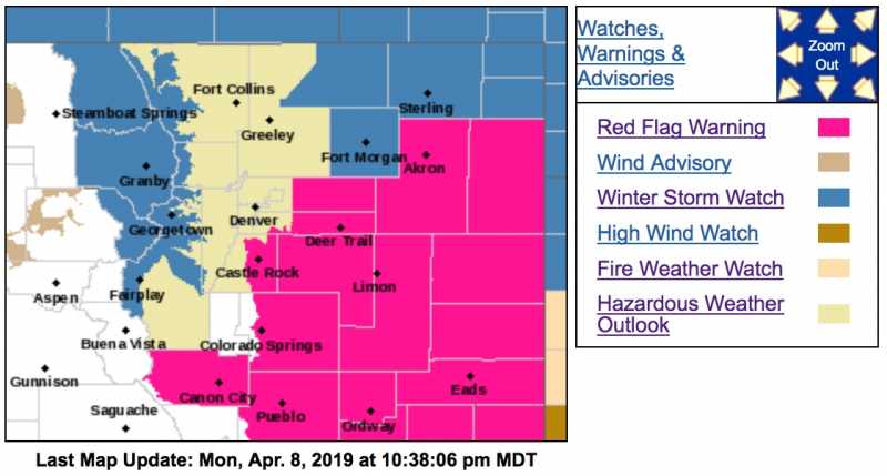
Winter Storm Watch
URGENT - WINTER WEATHER MESSAGE
National Weather Service Denver CO
950 PM MDT Mon Apr 8 2019
...STRONG WINTER STORM EXPECTED TO MOVE IN WEDNESDAY AFTERNOON...
.Very warm temperatures are expected on Tuesday, ahead of a developing upper level storm system moving over the Great Basin. Drastic changes in the weather are expected to occur on Wednesday. A strong cold front will be moving over northeast Colorado during the afternoon which will bring much colder temperatures, gusty north winds and rain changing over to snow. This storm system will have many similarities to the strong storm that moved over northeast Colorado back in mid-March. Although, snow amounts and wind speeds may not be as strong as the March storm, residents of northeast Colorado should begin making preparations for this developing storm to avoid being caught by hazardous weather conditions.
COZ030>034-091400-
/O.CON.KBOU.WS.A.0007.190410T1200Z-190411T1800Z/
North Park-Rabbit Ears Pass-
Grand and Summit Counties Below 9000 Feet-
Rocky Mountain National Park and the Medicine Bow Range-
The Mountains of Summit County, the Mosquito Range, and the Indian Peaks-
Including the cities of Gould, North Park, Rand, Spicer, Walden, East Slopes Park and Northern Gore Ranges, Gore Pass, Rabbit Ears Pass, Dillon, Fraser, Granby, Grand Lake, Hot Sulphur Springs, Kremmling, Cameron Pass, Laramie and Medicine Bow Mountains, Rabbit Ears Range, Rocky Mountain National Park, Willow Creek Pass, Berthoud Pass, Breckenridge, East Slopes Mosquito Range, East Slopes Southern Gore Range, Eisenhower Tunnel, Indian Peaks, Kenosha Mountains, Mount Evans, Williams Fork Mountains, and Winter Park
950 PM MDT Mon Apr 8 2019
...WINTER STORM WATCH REMAINS IN EFFECT FROM WEDNESDAY MORNING THROUGH THURSDAY MORNING...
* WHAT...Heavy snow possible. Total snow accumulations of 6 to 12 inches with some areas seeing up to 16 inches. Winds could gust as high as 35 mph.
* WHERE...The mountains and high parks of north central Colorado.
* WHEN...From Wednesday morning through Thursday morning.
* ADDITIONAL DETAILS...Travel could be very difficult. Patchy blowing snow could significantly reduce visibility. The hazardous conditions could impact the travel through the entire period.
PRECAUTIONARY/PREPAREDNESS ACTIONS...
A Winter Storm Watch means there is potential for significant snow, sleet or ice accumulations that may impact travel. Continue to monitor the latest forecasts.
Winter Storm Warning for April 10, 2019 was created by MountainTownAlerts
Winter Storm Watch
URGENT - WINTER WEATHER MESSAGE
National Weather Service Denver CO
950 PM MDT Mon Apr 8 2019
...STRONG WINTER STORM EXPECTED TO MOVE IN WEDNESDAY AFTERNOON...
.Very warm temperatures are expected on Tuesday, ahead of a developing upper level storm system moving over the Great Basin. Drastic changes in the weather are expected to occur on Wednesday. A strong cold front will be moving over northeast Colorado during the afternoon which will bring much colder temperatures, gusty north winds and rain changing over to snow. This storm system will have many similarities to the strong storm that moved over northeast Colorado back in mid-March. Although, snow amounts and wind speeds may not be as strong as the March storm, residents of northeast Colorado should begin making preparations for this developing storm to avoid being caught by hazardous weather conditions.
COZ030>034-091400-
/O.CON.KBOU.WS.A.0007.190410T1200Z-190411T1800Z/
North Park-Rabbit Ears Pass-
Grand and Summit Counties Below 9000 Feet-
Rocky Mountain National Park and the Medicine Bow Range-
The Mountains of Summit County, the Mosquito Range, and the Indian Peaks-
Including the cities of Gould, North Park, Rand, Spicer, Walden, East Slopes Park and Northern Gore Ranges, Gore Pass, Rabbit Ears Pass, Dillon, Fraser, Granby, Grand Lake, Hot Sulphur Springs, Kremmling, Cameron Pass, Laramie and Medicine Bow Mountains, Rabbit Ears Range, Rocky Mountain National Park, Willow Creek Pass, Berthoud Pass, Breckenridge, East Slopes Mosquito Range, East Slopes Southern Gore Range, Eisenhower Tunnel, Indian Peaks, Kenosha Mountains, Mount Evans, Williams Fork Mountains, and Winter Park
950 PM MDT Mon Apr 8 2019
...WINTER STORM WATCH REMAINS IN EFFECT FROM WEDNESDAY MORNING THROUGH THURSDAY MORNING...
* WHAT...Heavy snow possible. Total snow accumulations of 6 to 12 inches with some areas seeing up to 16 inches. Winds could gust as high as 35 mph.
* WHERE...The mountains and high parks of north central Colorado.
* WHEN...From Wednesday morning through Thursday morning.
* ADDITIONAL DETAILS...Travel could be very difficult. Patchy blowing snow could significantly reduce visibility. The hazardous conditions could impact the travel through the entire period.
PRECAUTIONARY/PREPAREDNESS ACTIONS...
A Winter Storm Watch means there is potential for significant snow, sleet or ice accumulations that may impact travel. Continue to monitor the latest forecasts.
Last edit: 09 Apr 2019 15:42 by MyMountainTown. Reason: change in status from Watch to Warning
Please Log in or Create an account to join the conversation.
- MountainTownAlerts
-
Topic Author
- Mountain Legend
-
Less
More
- Posts: 9766
- Thank you received: 221
09 Apr 2019 09:39 #2
by MountainTownAlerts
Replied by MountainTownAlerts on topic Winter Storm Warning for April 10, 2019
Expanded to include more of Park County and now Jefferson County as well. Per our Chief Meteorologist Steve Hamilton:
Winter Storm Watch: Fairplay / Jefferson / Como / Alma...
It's looking like we'll be getting more snow across the foothills, and into eastern Colorado as well. A strong low will be developing tomorrow, then trekking across the state Wednesday afternoon into Thursday. All-snow is likely for Jefferson, Fairplay, Como and Alma, with a mix of rain and snow elsewhere. Here's the catch: Depending on the exact track of the low, temperatures will either remain warm enough for a rain/snow mix for the rest of the foothills, or possibly all-snow. Tuesday's model runs should reveal more of those details. In any case, precipitation is likely along with gusty wind and much colder temperatures.
mymountaintown.com/expert-local-weather
Winter Storm Watch
URGENT - WINTER WEATHER MESSAGE
National Weather Service Denver CO
437 AM MDT Tue Apr 9 2019
...STRONG WINTER STORM EXPECTED TO MOVE IN WEDNESDAY AFTERNOON...
.Very warm temperatures are expected on Tuesday, ahead of a developing upper level storm system moving over the Great Basin. Drastic changes in the weather are expected to occur on Wednesday. A strong cold front will race across northeast Colorado Wednesday which will bring much colder temperatures, strong north winds and heavy snow. Areas of heaviest snowfall are still uncertain at this time and my occur anywhere from the Front Range to the far eastern plains. Residents of northeast Colorado should begin making preparations for this developing storm to avoid being caught by harsh winter conditions.
COZ035-036-091845-
/O.EXB.KBOU.WS.A.0007.190410T1500Z-190411T1800Z/
The Northern Front Range Foothills-
The Southern Front Range Foothills-
Including the cities of Estes Park, Glendevey, Nederland, Red Feather Lakes, Bailey, Central City, Evergreen, Georgetown, Idaho Springs, and Westcreek
437 AM MDT Tue Apr 9 2019
...WINTER STORM WATCH IN EFFECT FROM WEDNESDAY MORNING THROUGH THURSDAY MORNING...
* WHAT...Heavy snow and blowing snow possible. Total snow accumulations of 5 to 10 inches possible. A few locations may see greater than a foot of snow. Winds could gust as high as 45 mph.
* WHERE...The Northern Front Range Foothills and The Southern Front Range Foothills.
* WHEN...From Wednesday morning through Thursday morning.
* ADDITIONAL DETAILS...Travel could become very difficult. Areas of blowing snow could significantly reduce visibility. The hazardous conditions could impact the morning and evening commutes. Road closures could limit travel options by Wednesday night. Strong winds could cause tree damage and power outages.
PRECAUTIONARY/PREPAREDNESS ACTIONS...
A Winter Storm Watch means there is potential for significant snow, sleet or ice accumulations that may impact travel. Continue to monitor the latest forecasts.
Please Log in or Create an account to join the conversation.
- MountainTownAlerts
-
Topic Author
- Mountain Legend
-
Less
More
- Posts: 9766
- Thank you received: 221
09 Apr 2019 15:53 #3
by MountainTownAlerts
Replied by MountainTownAlerts on topic Winter Storm Warning for April 10, 2019
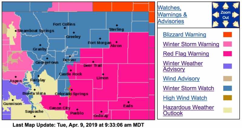
The Winter Storm Watch is now upgraded to a Winter Storm Warning.

URGENT - WINTER WEATHER MESSAGE
National Weather Service Denver CO
1147 AM MDT Tue Apr 9 2019
...STRONG WINTER STORM EXPECTED TO MOVE IN WEDNESDAY...
.Very warm temperatures are expected today, ahead of a developing upper level storm system moving over the Great Basin. Drastic changes in the weather are expected to occur on Wednesday as a strong cold front will race across northeast Colorado which will bring much colder temperatures, strong north winds and heavy snow. Areas of heavy snowfall across the Front Range to the far eastern plains and strong winds will result in poor visibility and difficult driving conditions. Temperatures plummeting will result in icy roads. Residents of northeast Colorado should begin making preparations for this developing storm to avoid being caught by harsh winter conditions.
COZ035-036-100200-
/O.UPG.KBOU.WS.A.0007.190410T1500Z-190411T1800Z/
/O.NEW.KBOU.WS.W.0009.190410T1500Z-190411T1800Z/
The Northern Front Range Foothills-
The Southern Front Range Foothills-
Including the cities of Estes Park, Glendevey, Nederland, Red Feather Lakes, Bailey, Central City, Evergreen, Georgetown, Idaho Springs, and Westcreek
1147 AM MDT Tue Apr 9 2019
...WINTER STORM WARNING IN EFFECT FROM 9 AM WEDNESDAY TO NOON MDT THURSDAY...
* WHAT...Heavy snow expected. Total snow accumulations of 5 to 10 inches expected. A few locations could see as much as a foot. Winds gusting as high as 45 mph.
* WHERE...The Northern Front Range Foothills and The Southern Front Range Foothills.
* WHEN...From 9 AM Wednesday to noon MDT Thursday.
* ADDITIONAL DETAILS...Travel could be very difficult. Patchy blowing snow could significantly reduce visibility. The hazardous conditions will likely impact the morning and more so the evening commute. Gusty winds could bring down tree branches.
PRECAUTIONARY/PREPAREDNESS ACTIONS...
A Winter Storm Warning for snow means severe winter weather conditions will make travel very hazardous or impossible. If you must travel, keep an extra flashlight, food and water in your vehicle in case of an emergency.
The latest road conditions for the state you are calling from can be obtained by calling 5 1 1.
URGENT - WINTER WEATHER MESSAGE
National Weather Service Denver CO
1147 AM MDT Tue Apr 9 2019
COZ030-031-033-034-100200-
/O.UPG.KBOU.WS.A.0007.190410T1200Z-190411T1800Z/
/O.NEW.KBOU.WS.W.0009.190410T1200Z-190411T1800Z/
North Park-Rabbit Ears Pass-
Rocky Mountain National Park and the Medicine Bow Range-
The Mountains of Summit County, the Mosquito Range, and the Indian Peaks-
Including the cities of Gould, North Park, Rand, Spicer, Walden, East Slopes Park and Northern Gore Ranges, Gore Pass, Rabbit Ears Pass, Cameron Pass, Laramie and Medicine Bow Mountains, Rabbit Ears Range, Rocky Mountain National Park, Willow Creek Pass, Berthoud Pass, Breckenridge, East Slopes Mosquito Range, East Slopes Southern Gore Range, Eisenhower Tunnel, Indian Peaks, Kenosha Mountains, Mount Evans, Williams Fork Mountains, and Winter Park
1147 AM MDT Tue Apr 9 2019
...WINTER STORM WARNING IN EFFECT FROM 6 AM WEDNESDAY TO NOON MDT THURSDAY...
* WHAT...Heavy snow expected. Total snow accumulations of 6 to 13 inches expected. Some areas could see up to 18 inches, especially over the Medicine Bow mountains. Winds gusting as high as 35 mph.
* WHERE...North Park, Rabbit Ears Pass, Rocky Mountain National Park and the Medicine Bow Range and The Mountains of Summit County, the Mosquito Range, and the Indian Peaks.
* WHEN...From 6 AM Wednesday to noon MDT Thursday.
* ADDITIONAL DETAILS...Travel could be very difficult. Patchy blowing snow could significantly reduce visibility. The hazardous conditions will likely impact the morning and more so the evening commute.
URGENT - WINTER WEATHER MESSAGE
National Weather Service Denver CO
1147 AM MDT Tue Apr 9 2019
COZ039-100200-
/O.UPG.KBOU.WS.A.0007.190410T1800Z-190411T1800Z/
/O.NEW.KBOU.WS.W.0009.190410T1800Z-190411T1800Z/
Boulder and the western suburbs of Denver-
Including the cities of Arvada, Boulder, Golden, Lakewood, and Longmont
1147 AM MDT Tue Apr 9 2019
...WINTER STORM WARNING IN EFFECT FROM NOON WEDNESDAY TO NOON MDT
THURSDAY...
* WHAT...Heavy snow expected. Total snow accumulations of 3 to 5 inches expected. Winds gusting as high as 40 mph.
* WHERE...Boulder and the western suburbs of Denver.
* WHEN...From noon Wednesday to noon MDT Thursday.
* ADDITIONAL DETAILS...Plan on slippery road conditions. The hazardous conditions will impact the evening commute.
URGENT - WINTER WEATHER MESSAGE
National Weather Service Denver CO
1147 AM MDT Tue Apr 9 2019
...STRONG WINTER STORM EXPECTED TO MOVE IN WEDNESDAY...
.Very warm temperatures are expected today, ahead of a developing upper level storm system moving over the Great Basin. Drastic changes in the weather are expected to occur on Wednesday as a strong cold front will race across northeast Colorado which will bring much colder temperatures, strong north winds and heavy snow. Areas of heavy snowfall across the Front Range to the far eastern plains and strong winds will result in poor visibility and difficult driving conditions. Temperatures plummeting will result in icy roads. Residents of northeast Colorado should begin making preparations for this developing storm to avoid being caught by harsh winter conditions.
COZ035-036-100200-
/O.UPG.KBOU.WS.A.0007.190410T1500Z-190411T1800Z/
/O.NEW.KBOU.WS.W.0009.190410T1500Z-190411T1800Z/
The Northern Front Range Foothills-
The Southern Front Range Foothills-
Including the cities of Estes Park, Glendevey, Nederland, Red Feather Lakes, Bailey, Central City, Evergreen, Georgetown, Idaho Springs, and Westcreek
1147 AM MDT Tue Apr 9 2019
...WINTER STORM WARNING IN EFFECT FROM 9 AM WEDNESDAY TO NOON MDT THURSDAY...
* WHAT...Heavy snow expected. Total snow accumulations of 5 to 10 inches expected. A few locations could see as much as a foot. Winds gusting as high as 45 mph.
* WHERE...The Northern Front Range Foothills and The Southern Front Range Foothills.
* WHEN...From 9 AM Wednesday to noon MDT Thursday.
* ADDITIONAL DETAILS...Travel could be very difficult. Patchy blowing snow could significantly reduce visibility. The hazardous conditions will likely impact the morning and more so the evening commute. Gusty winds could bring down tree branches.
PRECAUTIONARY/PREPAREDNESS ACTIONS...
A Winter Storm Warning for snow means severe winter weather conditions will make travel very hazardous or impossible. If you must travel, keep an extra flashlight, food and water in your vehicle in case of an emergency.
The latest road conditions for the state you are calling from can be obtained by calling 5 1 1.
URGENT - WINTER WEATHER MESSAGE
National Weather Service Denver CO
1147 AM MDT Tue Apr 9 2019
COZ030-031-033-034-100200-
/O.UPG.KBOU.WS.A.0007.190410T1200Z-190411T1800Z/
/O.NEW.KBOU.WS.W.0009.190410T1200Z-190411T1800Z/
North Park-Rabbit Ears Pass-
Rocky Mountain National Park and the Medicine Bow Range-
The Mountains of Summit County, the Mosquito Range, and the Indian Peaks-
Including the cities of Gould, North Park, Rand, Spicer, Walden, East Slopes Park and Northern Gore Ranges, Gore Pass, Rabbit Ears Pass, Cameron Pass, Laramie and Medicine Bow Mountains, Rabbit Ears Range, Rocky Mountain National Park, Willow Creek Pass, Berthoud Pass, Breckenridge, East Slopes Mosquito Range, East Slopes Southern Gore Range, Eisenhower Tunnel, Indian Peaks, Kenosha Mountains, Mount Evans, Williams Fork Mountains, and Winter Park
1147 AM MDT Tue Apr 9 2019
...WINTER STORM WARNING IN EFFECT FROM 6 AM WEDNESDAY TO NOON MDT THURSDAY...
* WHAT...Heavy snow expected. Total snow accumulations of 6 to 13 inches expected. Some areas could see up to 18 inches, especially over the Medicine Bow mountains. Winds gusting as high as 35 mph.
* WHERE...North Park, Rabbit Ears Pass, Rocky Mountain National Park and the Medicine Bow Range and The Mountains of Summit County, the Mosquito Range, and the Indian Peaks.
* WHEN...From 6 AM Wednesday to noon MDT Thursday.
* ADDITIONAL DETAILS...Travel could be very difficult. Patchy blowing snow could significantly reduce visibility. The hazardous conditions will likely impact the morning and more so the evening commute.
URGENT - WINTER WEATHER MESSAGE
National Weather Service Denver CO
1147 AM MDT Tue Apr 9 2019
COZ039-100200-
/O.UPG.KBOU.WS.A.0007.190410T1800Z-190411T1800Z/
/O.NEW.KBOU.WS.W.0009.190410T1800Z-190411T1800Z/
Boulder and the western suburbs of Denver-
Including the cities of Arvada, Boulder, Golden, Lakewood, and Longmont
1147 AM MDT Tue Apr 9 2019
...WINTER STORM WARNING IN EFFECT FROM NOON WEDNESDAY TO NOON MDT
THURSDAY...
* WHAT...Heavy snow expected. Total snow accumulations of 3 to 5 inches expected. Winds gusting as high as 40 mph.
* WHERE...Boulder and the western suburbs of Denver.
* WHEN...From noon Wednesday to noon MDT Thursday.
* ADDITIONAL DETAILS...Plan on slippery road conditions. The hazardous conditions will impact the evening commute.
Please Log in or Create an account to join the conversation.
- MountainTownAlerts
-
Topic Author
- Mountain Legend
-
Less
More
- Posts: 9766
- Thank you received: 221
10 Apr 2019 07:55 #4
by MountainTownAlerts
Replied by MountainTownAlerts on topic Winter Storm Warning for April 10, 2019
@NWSBoulder: Wondering when your snow will start? This morning in the mountains, early afternoon in the foothills and I-25 urban corridor, and mid afternoon on the plains. Foothills and plains will see it begin as rain, then switch over. #cowx
Please Log in or Create an account to join the conversation.
- Forum
- Life Up the Hill
- Scanner & Emergency Info, Weather Forecasts
- Winter Storm Warning for April 10, 2019
Time to create page: 0.198 seconds
sponsors


