From Chief Meteorologist Steve Hamilton:
MMT Weather Update: Winter Storm Warning...
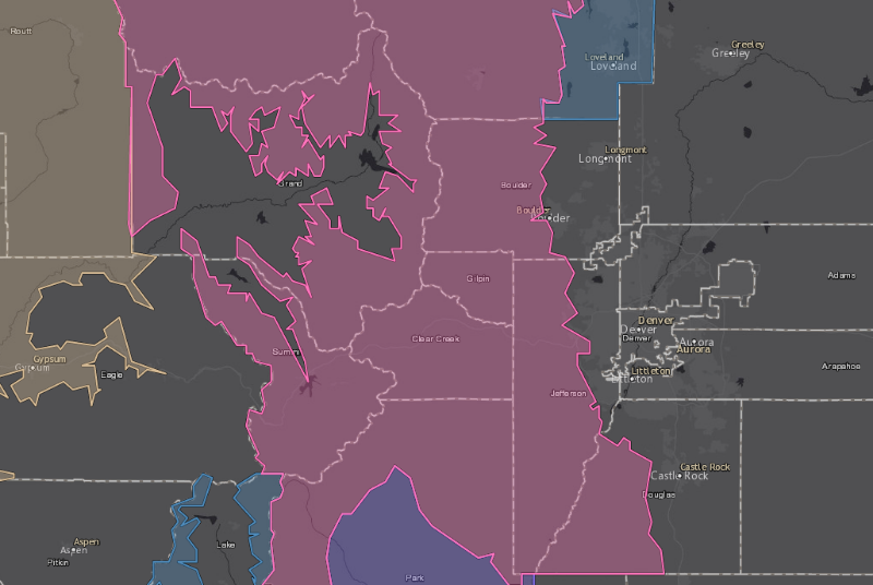
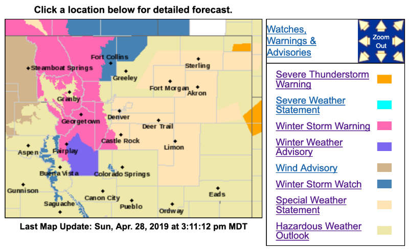
The National Weather Service has issued a Winter Storm Warning for the Front Range Foothills, in effect from 6:00 a.m. Monday to 6:00 a.m. Tuesday. Snowfall accumulation of 8 to 16 inches is possible throughout the foothills. Prepare for hazardous driving conditions for the Monday commute, into Tuesday morning.
A Gusty Weekend... Rain And Snow Showers Sunday...
A low will develop over southeast Colorado on Sunday, and in combination with a cold front, will bring rain and snow showers to the foothills. Most areas will see at least a mix of rain and snow Sunday night into Monday. All-snow is likely above 7,000 feet Sunday night and most of Monday. Surface temperatures should preclude any significant accumulation. Still, roads could become slick or snow-covered, especially late Sunday and into the Monday morning commute.
Winter Storm Warning
URGENT - WINTER WEATHER MESSAGE
National Weather Service Denver CO
208 PM MDT Sun Apr 28 2019
...Heavy Snow Monday and Monday Night for the Mountains, Foothills, and Lower Elevations near Wyoming...
.A Spring snow storm will move into the region Monday and continue into Wednesday with multiple rounds of moderate to heavy snow at across central and north central Colorado. Some snow will also spread onto the plains with accumulations likely. The heaviest snow is expected to occur over northern Colorado. Stay tuned for additional updates.
COZ033>036-291000-
/O.UPG.KBOU.WS.A.0008.190429T1200Z-190430T1200Z/
/O.NEW.KBOU.WS.W.0010.190429T1200Z-190430T1200Z/
Rocky Mountain National Park and the Medicine Bow Range-
The Mountains of Summit County, the Mosquito Range, and the Indian Peaks-
The Northern Front Range Foothills-
The Southern Front Range Foothills-
Including the cities of Cameron Pass, Laramie and Medicine Bow Mountains, Rabbit Ears Range, Rocky Mountain National Park, Willow Creek Pass,
Berthoud Pass, Breckenridge, East Slopes Mosquito Range, East Slopes Southern Gore Range, Eisenhower Tunnel, Indian Peaks, Kenosha Mountains, Mount Evans, Williams Fork Mountains, Winter Park, Estes Park, Glendevey, Nederland, Red Feather Lakes,
Bailey, Central City, Evergreen, Georgetown, Idaho Springs, and Westcreek
208 PM MDT Sun Apr 28 2019
...
WINTER STORM WARNING IN EFFECT FROM 6 AM MONDAY TO 6 AM MDT TUESDAY...
* WHAT...
Heavy snow expected. Total snow accumulations of 8 to 16 inches expected.
* WHERE...Rocky Mountain National Park and the Medicine Bow Range, The Mountains of Summit County, the Mosquito Range, and the Indian Peaks, The Northern Front Range Foothills and The Southern Front Range Foothills.
* WHEN...From 6 AM Monday to 6 AM MDT Tuesday.
* ADDITIONAL DETAILS...Travel could be very difficult. The hazardous conditions could impact the morning or evening commute. Heavy snow on tree branches could cause some branches to break.
PRECAUTIONARY/PREPAREDNESS ACTIONS...
A Winter Storm Warning for snow means severe winter weather conditions will make travel very hazardous or impossible. If you must travel, keep an extra flashlight, food and water in your vehicle in case of an emergency.
The latest road conditions for the state you are calling from can be obtained by calling 5 1 1.
[/b]
Winter Weather Advisory
URGENT - WINTER WEATHER MESSAGE
National Weather Service Denver CO
208 PM MDT Sun Apr 28 2019
COZ037-291000-
/O.UPG.KBOU.WS.A.0008.190429T1200Z-190430T1200Z/
/O.NEW.KBOU.WW.Y.0022.190429T1200Z-190430T1200Z/
South Park-
Including the cities of Fairplay, Hartsel, Lake George, and South Park
208 PM MDT Sun Apr 28 2019
...
WINTER WEATHER ADVISORY IN EFFECT FROM 6 AM MONDAY TO 6 AM MDT TUESDAY...
* WHAT...Snow expected.
Total snow accumulations of 3 to 7 inches expected.
* WHERE...South Park.
* WHEN...From 6 AM Monday to 6 AM MDT Tuesday.
* ADDITIONAL DETAILS...Plan on slippery road conditions. Heavy snow on tree branches could cause some branches to break.
PRECAUTIONARY/PREPAREDNESS ACTIONS...
A Winter Weather Advisory for snow means periods of snow will cause primarily travel difficulties. Expect snow covered roads and limited visibilities, and use caution while driving.
The latest road conditions for the state you are calling from can be obtained by calling 5 1 1.