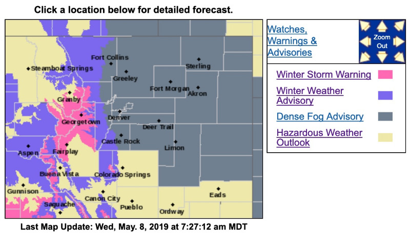
Winter Storm Warning
URGENT - WINTER WEATHER MESSAGE
National Weather Service Denver CO
422 AM MDT Wed May 8 2019
...ACCUMULATING SNOW FOR THE HIGH COUNTRY and along the Front Range...
.Snow showers will increase in the mountains this afternoon and continue through through Thursday. Rain showers will gradually change to snow in the foothills through the afternoon and should be all snow by this evening.
Significant snow accumulations are expected over the higher foothills and north central Colorado mountains. Relatively warm roads will reduce the impact initially, however, roads will likely become snow covered and icy overnight into Thursday morning.
Along the front range. rain will change to snow by mid to late evening and continue into Thursday morning. Roads across the Palmer Divide could become icy and snowpacked late tonight into Thursday morning, for the morning commute, with 3 to 6 inches of accumulation. Over the urban corridor snow amounts from 1 to 4 inches may occur with accumulations confined to grassy areas. Locally higher accumulations may occur near the base of the foothills with up to 6 inches possible.
COZ034-081830-
/O.UPG.KBOU.WW.Y.0024.190508T1800Z-190510T0000Z/
/O.NEW.KBOU.WS.W.0011.190508T1800Z-190510T0000Z/
The Mountains of Summit County, the Mosquito Range, and the Indian Peaks-
Including the cities of Berthoud Pass, Breckenridge,
East Slopes Mosquito Range, East Slopes Southern Gore Range, Eisenhower Tunnel, Indian Peaks, Kenosha Mountains, Mount Evans, Williams Fork Mountains, and Winter Park
422 AM MDT Wed May 8 2019
...
WINTER STORM WARNING IN EFFECT FROM NOON TODAY TO 6 PM MDT THURSDAY...
* WHAT...
Heavy snow expected. Total snow accumulations of 8 to 16 inches expected.
* WHERE...The Mountains of Summit County, the Mosquito Range, and the Indian Peaks.
* WHEN...From noon today to 6 PM MDT Thursday.
* ADDITIONAL DETAILS...Travel could be very difficult. The hazardous conditions could impact the morning or evening commute.
PRECAUTIONARY/PREPAREDNESS ACTIONS...
A Winter Storm Warning for snow means severe winter weather conditions will make travel very hazardous or impossible. If you must travel, keep an extra flashlight, food and water in your vehicle in case of an emergency.
The latest road conditions for the state you are calling from can be obtained by calling 5 1 1.
_ _ _ _ _ _ _ _ _ _ _ _ _ _ _ _ _ _ _ _ _ _ _ _ _ _ _ _ _ _ _ _ _ _ _ _ _ _ _ _ _ _ _ _ _ _ _ _ _
Winter Weather Advisory
URGENT - WINTER WEATHER MESSAGE
National Weather Service Denver CO
422 AM MDT Wed May 8 2019
...
ACCUMULATING SNOW FOR THE HIGH COUNTRY and along the Front Range...
.Snow showers will increase in the mountains this afternoon and continue through through Thursday.
Rain showers will gradually change to snow in the foothills through the afternoon and should be all snow by this evening.
Significant snow accumulations are expected over the higher foothills and north central Colorado mountains. Relatively warm roads will reduce the impact initially, however, roads will likely become snow covered and icy overnight into Thursday morning.
Along the front range. rain will change to snow by mid to late evening and continue into Thursday morning.
Roads across the Palmer Divide could become icy and snowpacked late tonight into Thursday morning, for the morning commute, with 3 to 6 inches of accumulation. Over the urban corridor snow amounts from 1 to 4 inches may occur with accumulations confined to grassy areas. Locally higher accumulations may occur near the base of the foothills with up to 6 inches possible.
COZ036-081830-
/O.CON.KBOU.WW.Y.0024.190508T1800Z-190510T0000Z/
The Southern Front Range Foothills-
Including the cities of Bailey, Central City, Evergreen, Georgetown, Idaho Springs, and Westcreek
422 AM MDT Wed May 8 2019
...
WINTER WEATHER ADVISORY REMAINS IN EFFECT FROM NOON TODAY TO 6 PM MDT THURSDAY...
* WHAT...Snow expected.
Total snow accumulations of 6 to 12 inches expected.
* WHERE...Southern Front Range Foothills.
* WHEN...From noon Wednesday to 6 PM MDT Thursday.
* ADDITIONAL DETAILS...Travel could be hazardous with slushy and snow covered roads at times.
PRECAUTIONARY/PREPAREDNESS ACTIONS...
A Winter Weather Advisory for snow means periods of snow will cause primarily travel difficulties. Expect snow covered roads and limited visibilities, and use caution while driving.
The latest road conditions for the state you are calling from can be obtained by calling 5 1 1.