From Chief Meteorologist Steve Hamilton:
My Mountain Town Weather: Winter Storm Warning in effect from noon Monday to midnight Tuesday. This affects some of the foothills: Alma, Fairplay, Como and Jefferson. However, snow accumulation is expected for other locations. We are updating the forecast and
will post it shortly.
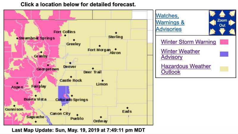
The highlighted parts of the map show the warning area. Expected snow totals for most locations will be in the 2-4 inch range, but in the warning area totals will likely exceed 8 inches.
Winter Storm Warning
URGENT - WINTER WEATHER MESSAGE
National Weather Service Denver CO
256 PM MDT Sun May 19 2019
...STRONG LATE SEASON SPRING STORM TO AFFECT COLORADO...
.A strong storm system will move into Colorado on Monday and continue to affect the area through Tuesday night. This system will bring heavy, wet snow to the mountains and northern foothills, impacting travel with snow covered and slushy roads.
COZ031-033-034-200500-
/O.UPG.KBOU.WS.A.0010.190520T1800Z-190522T0000Z/
/O.NEW.KBOU.WS.W.0012.190520T1800Z-190522T0600Z/
Rabbit Ears Pass-
Rocky Mountain National Park and the Medicine Bow Range-
The Mountains of Summit County, the Mosquito Range, and the Indian Peaks-
Including the cities of East Slopes Park and Northern Gore Ranges, Gore Pass, Rabbit Ears Pass, Cameron Pass, Laramie and Medicine Bow Mountains, Rabbit Ears Range, Rocky Mountain National Park, Willow Creek Pass,
Berthoud Pass, Breckenridge, East Slopes Mosquito Range, East Slopes Southern Gore Range, Eisenhower Tunnel, Indian Peaks, Kenosha Mountains, Mount Evans, Williams Fork Mountains, and Winter Park
256 PM MDT Sun May 19 2019
...
WINTER STORM WARNING IN EFFECT FROM NOON MONDAY TO MIDNIGHT MDT TUESDAY NIGHT...
* WHAT...Heavy snow expected. Total snow accumulations of 8 to 18 inches expected. Winds gusting as high as 35 mph.
* WHERE...Rabbit Ears Pass, Rocky Mountain National Park and the Medicine Bow Range and The Mountains of Summit County, the Mosquito Range, and the Indian Peaks.
* WHEN...From noon Monday to midnight MDT Tuesday night.
* ADDITIONAL DETAILS...Travel will be hazardous with snow covered roads. Secondary roads may see more difficult travel conditions due to more significant accumulation of heavy, wet snow.
PRECAUTIONARY/PREPAREDNESS ACTIONS...
A Winter Storm Warning for snow means severe winter weather conditions will make travel very hazardous or impossible. If you must travel, keep an extra flashlight, food and water in your vehicle in case of an emergency.
The latest road conditions for the state you are calling from can be obtained by calling 5 1 1.