- Posts: 9766
- Thank you received: 221
Wildfire South of Shawnee Peak
- MountainTownAlerts
-
 Topic Author
- Mountain Legend
-

Less
More
27 Aug 2019 10:57 #11
by MountainTownAlerts
Replied by MountainTownAlerts on topic Wildfire South of Shawnee Peak
CO - Emergency Mgmt @COEmergency 28m
At 9:44 a.m. @GovofCO
verbally approved an emergency declaration that authorizes the @CONG1860
to support the #ShawneePeakFire with helicopter search and rescue missions. The State of Colorado EOC and #DHSEM continue to monitor this #COFire incident.
West Metro Professional Firefighters @IAFF1309 1h
@westmetrofire
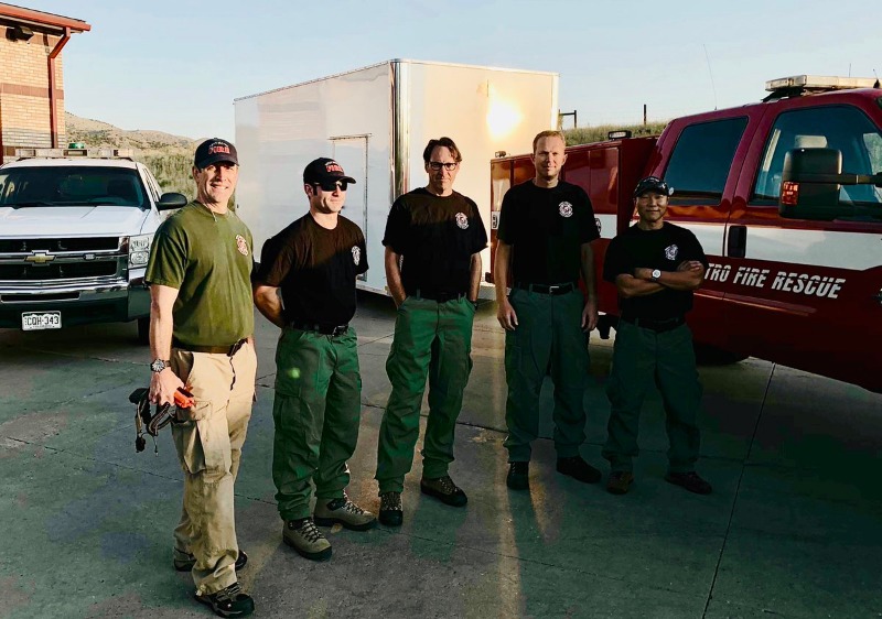
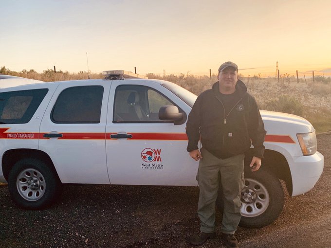
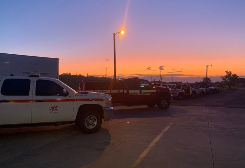
Wildland Crews heading out this morning to the #shawneepeakfire Fire near Bailey, CO. Line Medics and a REMS Team are heading west to aid in the firefight. The REMS and Medics will be on the fire line looking after other firefighters. #ShawneePeakFire
WestMetroFire @WestMetroFire 2h
Six of our firefighters this morning headed out to the #ShawneePeakFire near Bailey. Four are members of our REMS- or Rapid Extraction Team- responsible for rescuing injured firefighters & getting them to medical care. Two are line medics- and will treat injured firefighters.
Platte Canyon Professional Firefighters Local 4997
3 hrs ago
Platte Canyon Fire Module along with Pike Hotshots being flown into the Shawnee Peak Fire today.
At 9:44 a.m. @GovofCO
verbally approved an emergency declaration that authorizes the @CONG1860
to support the #ShawneePeakFire with helicopter search and rescue missions. The State of Colorado EOC and #DHSEM continue to monitor this #COFire incident.
West Metro Professional Firefighters @IAFF1309 1h
@westmetrofire
Wildland Crews heading out this morning to the #shawneepeakfire Fire near Bailey, CO. Line Medics and a REMS Team are heading west to aid in the firefight. The REMS and Medics will be on the fire line looking after other firefighters. #ShawneePeakFire
WestMetroFire @WestMetroFire 2h
Six of our firefighters this morning headed out to the #ShawneePeakFire near Bailey. Four are members of our REMS- or Rapid Extraction Team- responsible for rescuing injured firefighters & getting them to medical care. Two are line medics- and will treat injured firefighters.
Platte Canyon Professional Firefighters Local 4997
3 hrs ago
Platte Canyon Fire Module along with Pike Hotshots being flown into the Shawnee Peak Fire today.
The following user(s) said Thank You: elkcreekgeek
Please Log in or Create an account to join the conversation.
- MountainTownAlerts
-
Topic Author
- Mountain Legend
-
Less
More
- Posts: 9766
- Thank you received: 221
27 Aug 2019 11:24 #12
by MountainTownAlerts
Replied by MountainTownAlerts on topic Wildfire South of Shawnee Peak
Shawnee Peak Fire Update 11:00 am, 8/27/19 from PSICC_NF
Fire fighters are transported via helicopter to the Shawnee Peak Fire. Videos available below.
psiccfireinfo.blogspot.com/2019/08/fire-...-82619.html?spref=tw
Fire fighters are transported via helicopter to the Shawnee Peak Fire. Videos available below.
psiccfireinfo.blogspot.com/2019/08/fire-...-82619.html?spref=tw
Helicopters are shuttling crews to the fire. This saves precious time and energy. The distance to the fire on the trail is approximately 6 miles. 8/27/19
The following user(s) said Thank You: elkcreekgeek
Please Log in or Create an account to join the conversation.
- MountainTownAlerts
-
Topic Author
- Mountain Legend
-
Less
More
- Posts: 9766
- Thank you received: 221
28 Aug 2019 06:58 #13
by MountainTownAlerts
Replied by MountainTownAlerts on topic Wildfire South of Shawnee Peak
Shawnee Peak Fire
Update 10:30 pm, 8/27/19
Firefighters worked on constructing fireline that will tie into natural fuel breaks with the intent of keeping the fire below the ridgeline. Structure crews began assessing homes for fire risk in the Shawnee Community. Crews will stay in a spike camp near the fire overnight and will resume operations in the morning. Due to better mapping, the fire is now at 37 acres.
psiccfireinfo.blogspot.com/2019/08/fire-...19.html?spref=tw&m=1
The following user(s) said Thank You: elkcreekgeek
Please Log in or Create an account to join the conversation.
- MountainTownAlerts
-
Topic Author
- Mountain Legend
-
Less
More
- Posts: 9766
- Thank you received: 221
28 Aug 2019 11:53 #14
by MountainTownAlerts
Replied by MountainTownAlerts on topic Wildfire South of Shawnee Peak
PSICC Update 10:30 a.m., 8/28/19
Firefighters made excellent progress constructing handline along the west, north and east side of the fire perimeter. They worked on constructing indirect fireline from the southwestern and southeastern fire perimeter to the Craig Park Trail #68 due to hazardous conditions consisting of numerous snags and steep and rocky terrain along the southern fire perimeter. Several spot fires to the northwest and east of the fire were fully lined with assistance of helicopter water drops. A structure taskforce worked on assessing homes for fire risk and began hazardous fuel mitigation within the Shawnee community.
Crews will continue fireline construction as well as securing existing firelines. The structure taskforce will continue home assessment and hazardous fuel mitigation operations.
A red flag warning is in effect today from noon through 8:00 pm. Temperatures are expected to reach the 90s, relative humidity less than 10%, and winds up to 20 miles per hour.
psiccfireinfo.blogspot.com/2019/08/fire-activity-82619.html?m=1
The following user(s) said Thank You: elkcreekgeek
Please Log in or Create an account to join the conversation.
- MountainTownAlerts
-
Topic Author
- Mountain Legend
-
Less
More
- Posts: 9766
- Thank you received: 221
29 Aug 2019 08:46 #15
by MountainTownAlerts
Replied by MountainTownAlerts on topic Wildfire South of Shawnee Peak
PSICC Update 9:30 p.m., 8/28/19 The fire became more active today due to the increased temperatures and low humidities. Firefighters still made good progress as they continued work on reinforcing existing firelines.
psiccfireinfo.blogspot.com/2019/08/fire-...19.html?spref=tw&m=1
psiccfireinfo.blogspot.com/2019/08/fire-...19.html?spref=tw&m=1
Please Log in or Create an account to join the conversation.
- FredHayek
-

- Mountain Legend
-
Less
More
- Posts: 31234
- Thank you received: 181
29 Aug 2019 09:19 #16
by FredHayek
Thomas Sowell: There are no solutions, just trade-offs.
Replied by FredHayek on topic Wildfire South of Shawnee Peak
Thanks for this thread. I visited the area on Tuesday, lots of teams, local, Federal, and from other fire departments across Colorado. Thanks to all the firefighters, also saw two helicopters working the blaze.
Thomas Sowell: There are no solutions, just trade-offs.
Please Log in or Create an account to join the conversation.
- MountainTownAlerts
-
Topic Author
- Mountain Legend
-
Less
More
- Posts: 9766
- Thank you received: 221
29 Aug 2019 10:40 - 29 Aug 2019 19:15 #17
by MountainTownAlerts
Replied by MountainTownAlerts on topic Wildfire South of Shawnee Peak
USFS_Pike&San Isabel @PSICC_NF 1min ago
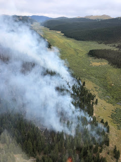
Firefighters are making great progress on the #ShawneePeakFire. It is currently 46 acres and is 10% contained. Images from the fire.
Update 10:00 a.m., 8/29/19 There was moderate fire activity yesterday with creeping, smoldering, and isolated and group torching. This produced more smoke, especially in the afternoon and early evening hours. Firefighters completed direct and indirect lines around the fire area. Firefighters completed structure assessments in Shawnee and continued work on hazardous fuel mitigation in the area.
The fire is expected to continue to burn within the direct and indirect firelines. Firefighters will patrol firelines, monitor for, and take action on any new fire starts outside the fire perimeter. Firefighter crews working in the Shawnee community will work toward completing hazardous fuel mitigation work. In addition, some resources will be available to assist on initial attack for any new fire starts not related to this fire.
psiccfireinfo.blogspot.com/

Park County @ParkCounty 9:53am
Public information boards for the Shawnee Peak Fire are located along Hwy 285 in Shawnee and Bailey. The Shawnee board just outside the Shawnee Tea Room. The Bailey board is located at the Loaf and Jug.
Firefighters are making great progress on the #ShawneePeakFire. It is currently 46 acres and is 10% contained. Images from the fire.
Update 10:00 a.m., 8/29/19 There was moderate fire activity yesterday with creeping, smoldering, and isolated and group torching. This produced more smoke, especially in the afternoon and early evening hours. Firefighters completed direct and indirect lines around the fire area. Firefighters completed structure assessments in Shawnee and continued work on hazardous fuel mitigation in the area.
The fire is expected to continue to burn within the direct and indirect firelines. Firefighters will patrol firelines, monitor for, and take action on any new fire starts outside the fire perimeter. Firefighter crews working in the Shawnee community will work toward completing hazardous fuel mitigation work. In addition, some resources will be available to assist on initial attack for any new fire starts not related to this fire.
psiccfireinfo.blogspot.com/
Park County @ParkCounty 9:53am
Public information boards for the Shawnee Peak Fire are located along Hwy 285 in Shawnee and Bailey. The Shawnee board just outside the Shawnee Tea Room. The Bailey board is located at the Loaf and Jug.
Last edit: 29 Aug 2019 19:15 by MyMountainTown.
Please Log in or Create an account to join the conversation.
- MountainTownAlerts
-
Topic Author
- Mountain Legend
-
Less
More
- Posts: 9766
- Thank you received: 221
29 Aug 2019 13:56 #18
by MountainTownAlerts
Replied by MountainTownAlerts on topic Wildfire South of Shawnee Peak
USFS_Pike&San Isabel (@PSICC_NF)
8/29/19, 1:51 PM
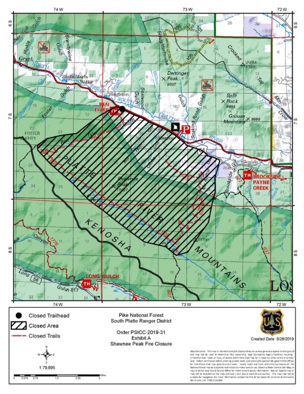
The South Platte Ranger District of the Pike National Forest has closed an area around the Shawnee Peak Fire for public safety. Hunters with tags in Game Management Unit 501 should check the map and adjust accordingly. All forest closure orders are here: www.fs.usda.gov/wps/portal/fsinternet/cs...lerts&cid=FSE_003753
8/29/19, 1:51 PM
The South Platte Ranger District of the Pike National Forest has closed an area around the Shawnee Peak Fire for public safety. Hunters with tags in Game Management Unit 501 should check the map and adjust accordingly. All forest closure orders are here: www.fs.usda.gov/wps/portal/fsinternet/cs...lerts&cid=FSE_003753
Please Log in or Create an account to join the conversation.
- MountainTownAlerts
-
Topic Author
- Mountain Legend
-
Less
More
- Posts: 9766
- Thank you received: 221
29 Aug 2019 19:15 #19
by MountainTownAlerts
Replied by MountainTownAlerts on topic Wildfire South of Shawnee Peak
Update 6:00 p.m., 8/29/19 Smoke is starting to push down into the valley with the development of an inversion layer. This will continue overnight and into the early morning.
psiccfireinfo.blogspot.com/
psiccfireinfo.blogspot.com/
Please Log in or Create an account to join the conversation.
- MountainTownAlerts
-
Topic Author
- Mountain Legend
-
Less
More
- Posts: 9766
- Thank you received: 221
30 Aug 2019 09:04 #20
by MountainTownAlerts
Replied by MountainTownAlerts on topic Wildfire South of Shawnee Peak
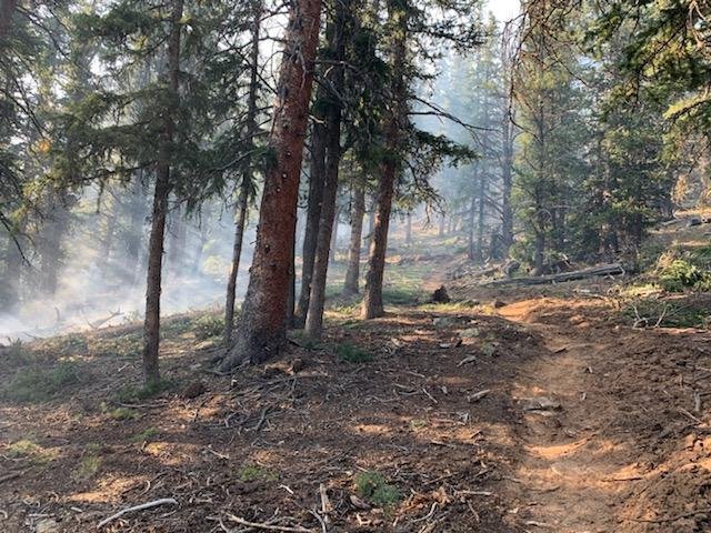
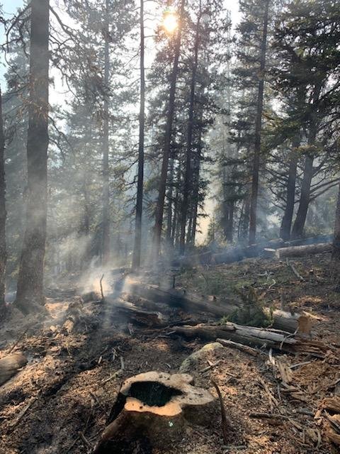
Update 7:30 a.m., 8/30/19 Fire activity yesterday continued to be moderate with creeping, smoldering, and isolated and group torching. Firefighters completed reinforcement of the fireline east of the fire and south along the Craig Creek Trail by burning out unburned fuel between the fire and the fireline. Firefighters also completed work on hazardous fuel removal around structures and debris cleanup.
The fire will continue to burn as it moves through unburned fuels between the fire perimeter and constructed firelines and natural fuel breaks. Fire activity will be monitored throughout the day.
Temperatures are expected to reach around 75 degrees, with westerly winds at 6-10 mph and gusts up to 20 mph. Scattered thunderstorms are possible after noon, which could create erratic winds near the areas of the storms.
The Pike and San Isabel National Forests issued a formal fire closure order for the area around, the Ben Tyler North trailhead and trails within the Shawnee Peak Fire. The closure does not include the Colorado Trail. All closed trails and trailheads are depicted on the closure map. A copy of the order and closure map is posted at www.fs.usda.gov/alerts/psicc/alerts-notices and scroll down to Closures.
Burning out unburned fuels north of the Craig Creek Trail toward the southern fire perimeter
More photos at: psiccfireinfo.blogspot.com/
Please Log in or Create an account to join the conversation.
Time to create page: 0.297 seconds
sponsors


