- Posts: 9766
- Thank you received: 221
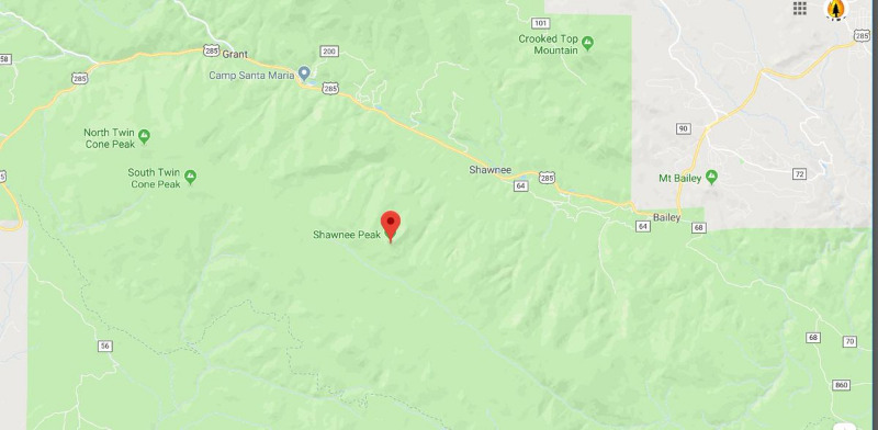
Wildfire South of Shawnee Peak
- MountainTownAlerts
-
 Topic Author
- Mountain Legend
-

Less
More
26 Aug 2019 15:50 #1
by MountainTownAlerts
Wildfire South of Shawnee Peak was created by MountainTownAlerts
Per cosmiccowboy55: wildland fire south of Shawnee Peak, USFS and Platte Canyon Fire responding. Calling for air support to fly over and help better pinpoint location, multiple calls for hotshot crew to report.
The following user(s) said Thank You: elkcreekgeek, snyden
Please Log in or Create an account to join the conversation.
- MountainTownAlerts
-
Topic Author
- Mountain Legend
-
Less
More
- Posts: 9766
- Thank you received: 221
26 Aug 2019 16:10 - 26 Aug 2019 16:26 #2
by MountainTownAlerts
Replied by MountainTownAlerts on topic Wildfire South of Shawnee Peak
Platte Canyon Fire Protection District
42 mins
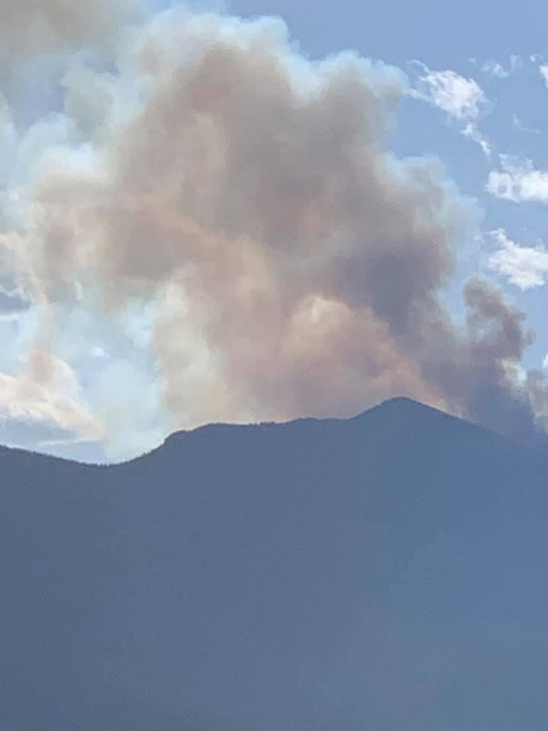
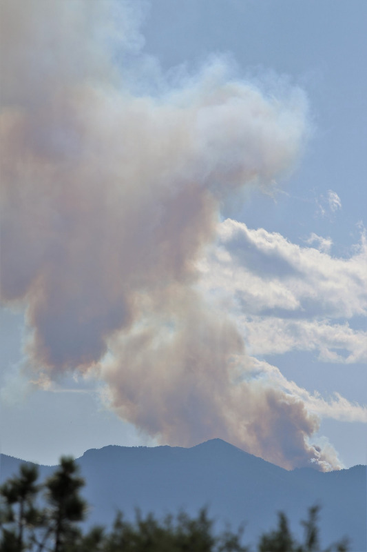
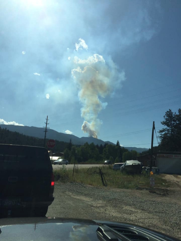
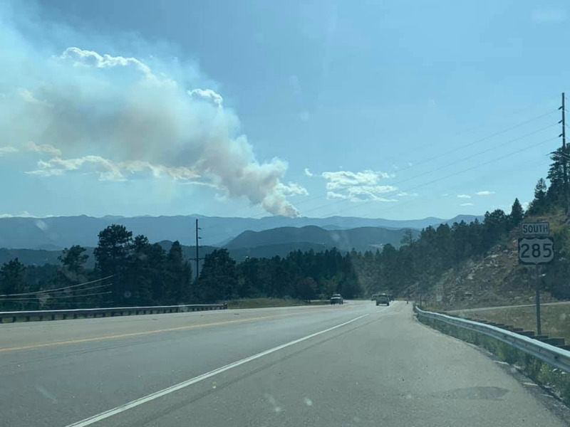
Confirmed wildfire in Lost Creek Wildness, #PCFD, #USFS in the area. Additional information to come. Smoke visible throughout Bailey Area, this is in the Pike National Forest; US Forest Service is leading this fire. No structures are threatened.
Photos posted to our Facebook Page: www.facebook.com/MyMountainTown
Bethany Darschewski-Van Beek:
Heather Mandish Ebaugh:
Nicholas Soleil:
Stacie Marshall Bracknell:
42 mins
Confirmed wildfire in Lost Creek Wildness, #PCFD, #USFS in the area. Additional information to come. Smoke visible throughout Bailey Area, this is in the Pike National Forest; US Forest Service is leading this fire. No structures are threatened.
Photos posted to our Facebook Page: www.facebook.com/MyMountainTown
Bethany Darschewski-Van Beek:
Heather Mandish Ebaugh:
Nicholas Soleil:
Stacie Marshall Bracknell:
Last edit: 26 Aug 2019 16:26 by MountainTownAlerts.
The following user(s) said Thank You: elkcreekgeek
Please Log in or Create an account to join the conversation.
- MountainTownAlerts
-
Topic Author
- Mountain Legend
-
Less
More
- Posts: 9766
- Thank you received: 221
26 Aug 2019 17:10 - 26 Aug 2019 17:16 #3
by MountainTownAlerts
Replied by MountainTownAlerts on topic Wildfire South of Shawnee Peak
Per cosmiccowboy55: fire is heading east. It's roughly south and west of Bailey about a mile each direction, maybe an 8-10 mile hike in for fire crews.
Shawnee Peak Fire - USFS_PSICC
A fire has been reported west of Kenosha Pass near the Shawnee Peak area. Crews are responding and currently trying to gain access the fire. The fire is burning in timber in a remote area of the National Forest. Fire is estimated at 20 acres
Time Reported: 3:15
Size: estimated 20 acres
Location: Near Shawnee Peak, West of Kenosha Pass
Jurisdiction: USFS
Resources: Multiple engine from the Forest Service and Platte Canyon FD, Type 3 Helicopter, 1 Hotshot Crew
Containment:0%
Controlled: N/A
Structures Threatened: N\A
Evacuation: N\A
Closures: N/A
Cause: Unknown
Fuels:Timber
#ShawneePeakFire
psiccfireinfo.blogspot.com/2019/08/fire-...-82619.html?spref=tw
From Park County: Posted on: August 26, 2019
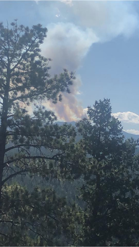
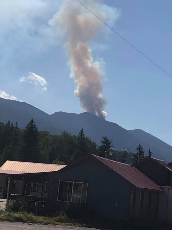
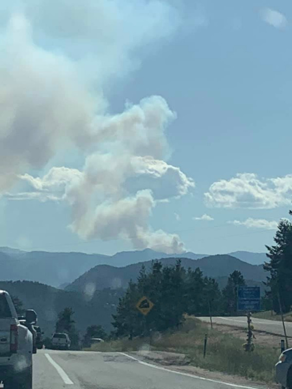
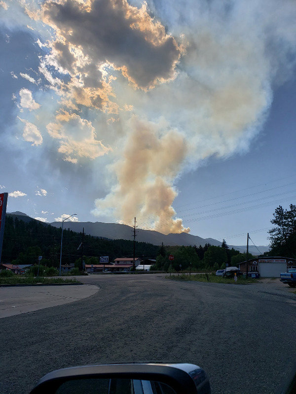
Smoke - Lost Park Wilderness Area
More photos shared to our Facebook Page:
From Sue Jasa Engels deck in Conifer:
From Marlis McAllister:
From Wade Waldrup in Bailey:
From Ian Howard at the top of Rchmond Hill in Conifer:
Screen grab from 9News live feed from the news helicopter:

Shawnee Peak Fire - USFS_PSICC
A fire has been reported west of Kenosha Pass near the Shawnee Peak area. Crews are responding and currently trying to gain access the fire. The fire is burning in timber in a remote area of the National Forest. Fire is estimated at 20 acres
Time Reported: 3:15
Size: estimated 20 acres
Location: Near Shawnee Peak, West of Kenosha Pass
Jurisdiction: USFS
Resources: Multiple engine from the Forest Service and Platte Canyon FD, Type 3 Helicopter, 1 Hotshot Crew
Containment:0%
Controlled: N/A
Structures Threatened: N\A
Evacuation: N\A
Closures: N/A
Cause: Unknown
Fuels:Timber
#ShawneePeakFire
psiccfireinfo.blogspot.com/2019/08/fire-...-82619.html?spref=tw
From Park County: Posted on: August 26, 2019
Smoke - Lost Park Wilderness Area
We are aware of the fire in the Lost Park Wilderness Area. There is no threat to any homes at this time.
Emergency Manager
More photos shared to our Facebook Page:
From Sue Jasa Engels deck in Conifer:
From Marlis McAllister:
From Wade Waldrup in Bailey:
From Ian Howard at the top of Rchmond Hill in Conifer:
Screen grab from 9News live feed from the news helicopter:
Last edit: 26 Aug 2019 17:16 by MountainTownAlerts. Reason: forgot last photo
The following user(s) said Thank You: elkcreekgeek
Please Log in or Create an account to join the conversation.
- MountainTownAlerts
-
Topic Author
- Mountain Legend
-
Less
More
- Posts: 9766
- Thank you received: 221
26 Aug 2019 17:46 - 26 Aug 2019 17:50 #4
by MountainTownAlerts
Replied by MountainTownAlerts on topic Wildfire South of Shawnee Peak
Per cosmiccowboy55: airtac 200 says they are seeing main growth to the south with few hot spots to the north, fire estimated at 37 acres by air
Last edit: 26 Aug 2019 17:50 by MountainTownAlerts. Reason: added new acreage estimate from cosmiccowboy55
The following user(s) said Thank You: elkcreekgeek
Please Log in or Create an account to join the conversation.
- MountainTownAlerts
-
Topic Author
- Mountain Legend
-
Less
More
- Posts: 9766
- Thank you received: 221
26 Aug 2019 17:53 #5
by MountainTownAlerts
Replied by MountainTownAlerts on topic Wildfire South of Shawnee Peak
Platte Canyon Fire @plattecanyonfd 28s
Update:
Shawnee Peak Fire
Fire size approximately 37 acres, per
Colorado Division of Fire Prevention and Control
who has mapped the fire via their MMA aircraft

Update:
Shawnee Peak Fire
Fire size approximately 37 acres, per
Colorado Division of Fire Prevention and Control
who has mapped the fire via their MMA aircraft
The following user(s) said Thank You: elkcreekgeek
Please Log in or Create an account to join the conversation.
- MountainTownAlerts
-
Topic Author
- Mountain Legend
-
Less
More
- Posts: 9766
- Thank you received: 221
26 Aug 2019 18:17 - 26 Aug 2019 18:44 #6
by MountainTownAlerts
Replied by MountainTownAlerts on topic Wildfire South of Shawnee Peak
Update 5:50pm, 8.26.19
Aircraft has flown over the fire and estimated the size to be 37 acres. Some isolated tree torching and spotting ahead of the fire has been observed. Firefighters on the ground are continuing to attempt to gain access to the fire.
Update 5pm, 8.26.19
A fire has been reported east of Kenosha Pass near the Shawnee Peak area. Crews are responding and currently trying to gain access the fire. The fire is burning in timber in a remote area of the National Forest.
Time Reported: 3:15pm
Size: 37 acres
Location: Near Shawnee Peak, East of Kenosha Pass
Jurisdiction: USFS
Resources: Multiple engine from the Forest Service and Platte Canyon FD, 2 Type 3 Helicopter, 1 Hotshot Crew, 1 Air Attack
Containment:0%
Controlled: N/A
Structures Threatened: N\A
psiccfireinfo.blogspot.com/2019/08/fire-...-82619.html?spref=tw
Last edit: 26 Aug 2019 18:44 by MountainTownAlerts. Reason: edit to correct fire location as east of Kenosha Pass
The following user(s) said Thank You: elkcreekgeek
Please Log in or Create an account to join the conversation.
- MountainTownAlerts
-
Topic Author
- Mountain Legend
-
Less
More
- Posts: 9766
- Thank you received: 221
26 Aug 2019 19:50 #7
by MountainTownAlerts
Replied by MountainTownAlerts on topic Wildfire South of Shawnee Peak
USFS_Pike&San Isabel @PSICC_NF 1m
Per the Park County Sheriff's Office the following trail heads have been closed due to the #ShawneePeakFire Ben Tyler, Brookside Payne Creek, North Fork, Long Gulch and Rock Creek trail heads.
psiccfireinfo.blogspot.com/2019/08/fire-...-82619.html?spref=tw
Per the Park County Sheriff's Office the following trail heads have been closed due to the #ShawneePeakFire Ben Tyler, Brookside Payne Creek, North Fork, Long Gulch and Rock Creek trail heads.
psiccfireinfo.blogspot.com/2019/08/fire-...-82619.html?spref=tw
The following user(s) said Thank You: elkcreekgeek
Please Log in or Create an account to join the conversation.
- MountainTownAlerts
-
Topic Author
- Mountain Legend
-
Less
More
- Posts: 9766
- Thank you received: 221
26 Aug 2019 21:15 #8
by MountainTownAlerts
Replied by MountainTownAlerts on topic Wildfire South of Shawnee Peak
USFS_Pike&San Isabel @PSICC_NF 42s
9pm update for the #ShawneePeakFire. Additional crews and aircraft have been ordered for this fire and will arrive tomorrow #COFire
psiccfireinfo.blogspot.com/2019/08/fire-...-82619.html?spref=tw
Shawnee Peak Fire
Update 9pm, 8/26/19
Numerous additional crews have been ordered for the Shawnee Peak Fire. There are now a total of 3 Hotshot crews assigned to this fire. One of those crews is currently working the fire and the others will arrive tomorrow. 2 additional hand crews have been assigned to the fire and will also arrive tomorrow (8/27). Several additional helicopters have also been ordered and will be working the fire tomorrow.
The following user(s) said Thank You: elkcreekgeek
Please Log in or Create an account to join the conversation.
- MountainTownAlerts
-
Topic Author
- Mountain Legend
-
Less
More
- Posts: 9766
- Thank you received: 221
27 Aug 2019 00:06 #9
by MountainTownAlerts
Replied by MountainTownAlerts on topic Wildfire South of Shawnee Peak
USFS_Pike&San Isabel @PSICC_NF
#ShawneePeakFire 11pm update. Fire is currently 40 acres, additional crews and aircraft to arrive tomorrow. New video upload of today's aerial recon flight.
psiccfireinfo.blogspot.com/2019/08/fire-...-82619.html?spref=tw
Shawnee Peak Fire
Update 11pm, 8/26/19
The Shawnee Peak Fire is currently burning 40 acres in a remote area of the Lost Creek Wilderness. Today crews attempted to gain access to the fire on the ground as helicopters and fixed wing aircraft did aerial recon and used bucket drops to help slow the fires growth. The area that the fire is burning in is very steep and rugged with very limited access. Firefighters report this evening that the fire is currently smoldering and creeping with isolated torching. A video of an aerial recon has been added below.
Tomorrow firefighters will be shuttled in via helicopter to asses the strategies and tactics to ensure the safety of the planned operations as firefighter safety is always priority. Helicopters will be utilized to both shuttle crews to the fire and for bucket drops on the fire. There will be a task force of engine crews that will be doing structure assessment and preplanning in and around the community of Shawnee which is still approximately 4 miles from the fire.
The following user(s) said Thank You: elkcreekgeek
Please Log in or Create an account to join the conversation.
- MountainTownAlerts
-
Topic Author
- Mountain Legend
-
Less
More
- Posts: 9766
- Thank you received: 221
27 Aug 2019 09:01 #10
by MountainTownAlerts
Replied by MountainTownAlerts on topic Wildfire South of Shawnee Peak
Shawnee Peak Fire
Update 7:45am, 8/27/19
The Shawnee Peak Fire briefing occurred at the AG Ranch in Shawnee this morning. Fire behavior is limited this morning due to higher humidity overnight. There are no road closures at this time. Five trail heads leading into the Lost Creek Wilderness have been closed. Fire fighters will be flown into the fire today and will begin fire suppression using natural features on the landscape to minimize suppression caused damage to natural and cultural resources. Fire engine crews will assess homes for fire risk in the Shawnee Community.
psiccfireinfo.blogspot.com/2019/08/fire-...-82619.html?spref=tw
Recap:
Time Reported: 3:15pm, 8/26/19
Size: 40 acres
Location: Near Shawnee Peak, east of Kenosha Pass (edited to correct earlier info of fire being west of Kenosha) in the Lost Creek Wilderness.
Jurisdiction: USFS
Resources: Multiple engines from the Forest Service and Platte Canyon FD, 2 -Type 3 Helicopters, 4 - Hotshot Crews, 2 - Type 2 IA Crews, 1 Air Attack, Additional helicopters have also been ordered and are expected to be on scene tomorrow (8/27), 1-REMS Team (rapid extraction/extrication) and multiple fireline medics
Containment:0%
Controlled: 0%
Structures Threatened: N\A
Evacuation: N\A
Closures: Per Park County Sheriff's Office the following trail heads have been closed: Ben Tyler, Brookside Payne Creek, North Fork, Long Gulch and Rock Creek.
Cause: Unknown
Fuels:Timber, Wilderness
#ShawneePeakFire
The following user(s) said Thank You: elkcreekgeek
Please Log in or Create an account to join the conversation.
Time to create page: 0.337 seconds
sponsors


