From Chief Meteorologist Steve Hamilton:
A Cold Front And Rain On The Way By Friday...
We're watching a cold front that should arrive over Colorado with showers, thunderstorms and cool temperatures. In the meantime, we'll have dry and breezy conditions Wednesday and most of Thursday. Wildfire danger will be high in the Fairplay, Jefferson/Como and Alma on Wednesday. Humidity is expected to be low, with warm temperatures and gusty wind. Ahead of the front late Thursday we may see a few showers. Then, we have a good chance of rain and thunderstorms Friday.
Check your town forecast here:
mymountaintown.com/expert-local-weather
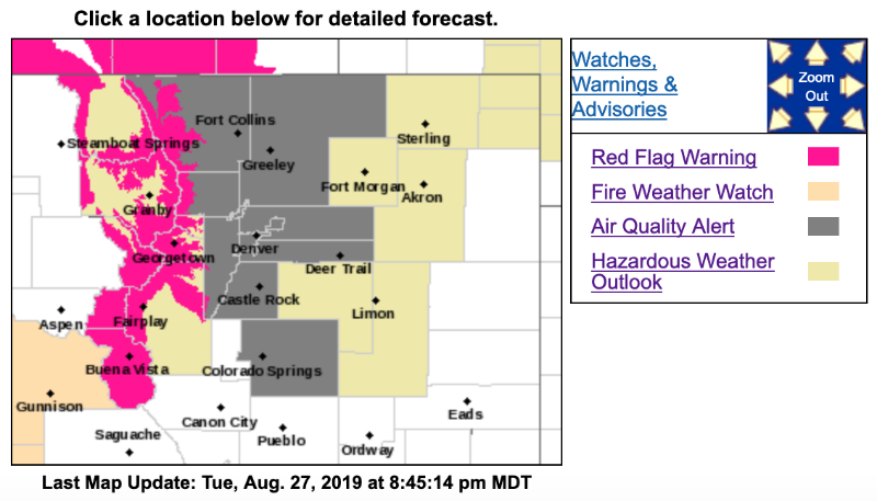
Air Quality Alert Is In Effect Until 4 PM Wednesday for most of the foothills and the Denver Metro Area. An "Ozone Action Day Alert" is now in effect for the Front Range Urban Corridor. Requests to limit driving are now in effect until at least 4 p.m. Wednesday, August 28, 2019. On Wednesday, light winds and sunny skies will lead to ozone concentrations in the Unhealthy for Sensitive Groups category.
The National Weather Service has issued a Red Flag Warning for high wildfire danger is in effect for part of the Front Range Foothills from 12PM to 8PM Wednesday for the Fairplay, Jefferson, Como and Alma areas. A combination of gusty wind, up to 25 mph, low relative humidity and warm temperatures will cause dangerously dry conditions, conducive to wildfires.
Red Flag Warning
URGENT - FIRE WEATHER MESSAGE
National Weather Service Denver/Boulder CO
305 PM MDT Tue Aug 27 2019
COZ212-217-218-280600-
/O.CON.KBOU.FW.W.0006.190828T1800Z-190829T0200Z/
South and Southeast Grand/West Central and Southwest Boulder/
Gilpin/Clear Creek/Summit/North and West Park Counties Above 9000 Feet-
West Jackson and West Grand Counties Above 9000 Feet-
South and East Jackson/Larimer/North and Northeast Grand/Northwest Boulder Counties Above 9000 Feet-
305 PM MDT Tue Aug 27 2019
...
RED FLAG WARNING REMAINS IN EFFECT FROM NOON TO 8 PM MDT WEDNESDAY FOR WIND AND LOW RELATIVE HUMIDITY FOR THE HIGH MOUNTAINS ABOVE 9000 FEET...ZONES 212...217 AND 218...
* Affected Area...Fire Weather Zones 212...217 and 218.
* Winds...West 10 to 20 mph with gusts up to 35 mph.
* Timing...Wednesday afternoon into early evening.
* Relative Humidity...As low as 11 percent.
* Impacts...Fires will be able to start and spread easily and quickly
PRECAUTIONARY/PREPAREDNESS ACTIONS...
A Red Flag Warning means that critical fire weather conditions are either occurring now....or will shortly. A combination of strong winds...low relative humidity...and warm temperatures can contribute to extreme fire behavior.
************************************************************
Hazardous Weather Outlook
National Weather Service Denver/Boulder CO
1055 AM MDT Tue Aug 27 2019
COZ030>051-281700-
Jackson County Below 9000 Feet-
West Jackson and West Grand Counties Above 9000 Feet-
Grand and Summit Counties Below 9000 Feet-
South and East Jackson/Larimer/North and Northeast Grand/
Northwest Boulder Counties Above 9000 Feet-
South and Southeast Grand/West Central and Southwest Boulder/
Gilpin/Clear Creek/Summit/North and West Park Counties Above
9000 Feet-
Larimer and Boulder Counties Between 6000 and 9000 Feet-
Jefferson and West Douglas Counties Above 6000 Feet/Gilpin/Clear Creek/Northeast Park Counties Below 9000 Feet-
Central and Southeast Park County-
Larimer County Below 6000 Feet/Northwest Weld County-
Boulder And Jefferson Counties Below 6000 Feet/West Broomfield County-
North Douglas County Below 6000 Feet/Denver/West Adams and Arapahoe Counties/East Broomfield County-
Elbert/Central and East Douglas Counties Above 6000 Feet-
Northeast Weld County-Central and South Weld County-Morgan County-
Central and East Adams and Arapahoe Counties-
North and Northeast Elbert County Below 6000 Feet/North Lincoln County-
Southeast Elbert County Below 6000 Feet/South Lincoln County-
Logan County-Washington County-Sedgwick County-Phillips County-
1055 AM MDT Tue Aug 27 2019
...
HIGH FIRE DANGER FOR THE MOUNTAINS WEDNESDAY...
This hazardous weather outlook is for northeast and north central Colorado.
.DAY ONE...Today and Tonight
No hazardous weather is expected. Isolated rain showers over the far northeast plains this morning will be diminishing through early afternoon. An isolated thunderstorm or two will be possible over the Palmer Divide late this afternoon into early evening.
.DAYS TWO THROUGH SEVEN...Wednesday through Monday
Warmer and drier conditions will spread over the area Wednesday, with high elevations expected to see wind gusts in the 25 to 35 mph range, elevating fire weather conditions...therefore a Red Flag Warning has been issued for elevations above 9000 feet. Outdoor burning is extremely discouraged as fires will be able to start and spread quickly in dry vegetation. Fire danger will lessen Thursday as moisture increases slightly.
Cooler temperatures and a chance of thunderstorms are expected for Friday and Saturday. Warm and dry conditions are expected to return Sunday.
.SPOTTER INFORMATION STATEMENT...
Spotter activation will not be needed today or tonight.