- Posts: 9766
- Thank you received: 221
- Forum
- Life Up the Hill
- Scanner & Emergency Info, Weather Forecasts
- Red Flag Warning Sunday Sept 29, Monday Sept 30
Red Flag Warning Sunday Sept 29, Monday Sept 30
- MountainTownAlerts
-
 Topic Author
- Mountain Legend
-

Less
More
28 Sep 2019 14:00 #1
by MountainTownAlerts
Red Flag Warning
URGENT - FIRE WEATHER MESSAGE
National Weather Service Denver/Boulder CO
1201 PM MDT Sat Sep 28 2019
...CRITICAL FIRE DANGER SUNDAY AND MONDAY DUE TO WARM... DRY AND WINDY CONDITIONS...
COZ212>214-216-241-245>247-249-290315-
/O.CON.KBOU.FW.W.0008.190929T1800Z-190930T0100Z/
/O.CON.KBOU.FW.A.0004.190930T1800Z-191001T0100Z/
South and Southeast Grand/West Central and Southwest Boulder/Gilpin/Clear Creek/Summit/North and West Park Counties Above 9000 Feet-
Grand and Summit Counties Below 9000 Feet-
Central and Southeast Park County-
Jefferson and West Douglas Counties Above 6000 Feet/Gilpin/Clear Creek/Northeast Park Counties Below 9000 Feet-
Elbert/Central and East Douglas Counties Above 6000 Feet-
Central and East Adams and Arapahoe Counties-
North and Northeast Elbert County Below 6000 Feet/North Lincoln County-
Southeast Elbert County Below 6000 Feet/South Lincoln County-
Washington County-
1201 PM MDT Sat Sep 28 2019
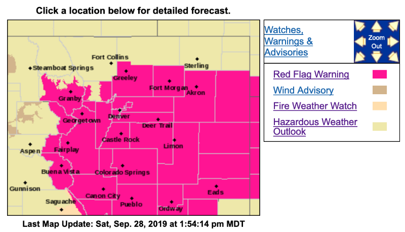
...RED FLAG WARNING REMAINS IN EFFECT FROM NOON TO 7 PM MDT SUNDAY FOR WIND AND LOW RELATIVE HUMIDITY FOR FOR MIDDLE AND SOUTH PARKS...SOUTHERN FOOTHILLS...PALMER DIVIDE AND PLAINS SOUTH OF A GREELEY TO AKRON LINE...
...FIRE WEATHER WATCH REMAINS IN EFFECT FROM MONDAY AFTERNOON THROUGH MONDAY EVENING FOR WIND AND LOW RELATIVE HUMIDITY FOR MIDDLE AND SOUTH PARKS...SOUTHERN FOOTHILLS...PALMER DIVIDE AND PLAINS SOUTHEAST AND SOUTH OF DENVER TO AKRON LINE...
* Affected Area...Fire Weather Zones 212...213...214...216...241...245...246...247 and 249.
* Winds...Southwest 20 to 30 mph with gusts up to 55 mph.
* Timing...Sunday afternoon, then again on Monday afternoon.
* Relative Humidity...12 to 17 percent Sunday, 9 to 14 percent Monday.
* Impacts...Conditions will be favorable for the rapid ignition, growth, and spread of fires
PRECAUTIONARY/PREPAREDNESS ACTIONS...
A Red Flag Warning means that critical fire weather conditions are either occurring now....or will shortly. A combination of strong winds...low relative humidity...and warm temperatures can contribute to extreme fire behavior.
A Fire Weather Watch means that critical fire weather conditions are forecast to occur. Listen for later forecasts and possible Red Flag Warnings.
Red Flag Warning
URGENT - FIRE WEATHER MESSAGE
National Weather Service Denver/Boulder CO
1201 PM MDT Sat Sep 28 2019
...CRITICAL FIRE DANGER SUNDAY AND MONDAY DUE TO WARM... DRY AND WINDY CONDITIONS...
COZ212>214-216-241-245>247-249-290315-
/O.CON.KBOU.FW.W.0008.190929T1800Z-190930T0100Z/
/O.CON.KBOU.FW.A.0004.190930T1800Z-191001T0100Z/
South and Southeast Grand/West Central and Southwest Boulder/Gilpin/Clear Creek/Summit/North and West Park Counties Above 9000 Feet-
Grand and Summit Counties Below 9000 Feet-
Central and Southeast Park County-
Jefferson and West Douglas Counties Above 6000 Feet/Gilpin/Clear Creek/Northeast Park Counties Below 9000 Feet-
Elbert/Central and East Douglas Counties Above 6000 Feet-
Central and East Adams and Arapahoe Counties-
North and Northeast Elbert County Below 6000 Feet/North Lincoln County-
Southeast Elbert County Below 6000 Feet/South Lincoln County-
Washington County-
1201 PM MDT Sat Sep 28 2019
...RED FLAG WARNING REMAINS IN EFFECT FROM NOON TO 7 PM MDT SUNDAY FOR WIND AND LOW RELATIVE HUMIDITY FOR FOR MIDDLE AND SOUTH PARKS...SOUTHERN FOOTHILLS...PALMER DIVIDE AND PLAINS SOUTH OF A GREELEY TO AKRON LINE...
...FIRE WEATHER WATCH REMAINS IN EFFECT FROM MONDAY AFTERNOON THROUGH MONDAY EVENING FOR WIND AND LOW RELATIVE HUMIDITY FOR MIDDLE AND SOUTH PARKS...SOUTHERN FOOTHILLS...PALMER DIVIDE AND PLAINS SOUTHEAST AND SOUTH OF DENVER TO AKRON LINE...
* Affected Area...Fire Weather Zones 212...213...214...216...241...245...246...247 and 249.
* Winds...Southwest 20 to 30 mph with gusts up to 55 mph.
* Timing...Sunday afternoon, then again on Monday afternoon.
* Relative Humidity...12 to 17 percent Sunday, 9 to 14 percent Monday.
* Impacts...Conditions will be favorable for the rapid ignition, growth, and spread of fires
PRECAUTIONARY/PREPAREDNESS ACTIONS...
A Red Flag Warning means that critical fire weather conditions are either occurring now....or will shortly. A combination of strong winds...low relative humidity...and warm temperatures can contribute to extreme fire behavior.
A Fire Weather Watch means that critical fire weather conditions are forecast to occur. Listen for later forecasts and possible Red Flag Warnings.
Please Log in or Create an account to join the conversation.
- ElkCreekFireDepartment
-
- Mountain Legend
-
29 Sep 2019 09:44 - 29 Sep 2019 09:59 #2
by ElkCreekFireDepartment
In case of emergency, please dial 911.
elkcreekfpd.colorado.gov/
Facebook Page
Twitter
Instagram
303-816-9385 (Office Hours M-F 8:00-4:30)
This email address is being protected from spambots. You need JavaScript enabled to view it.
Replied by ElkCreekFireDepartment on topic Red Flag Warning Sunday Sept 29, Monday Sept 30
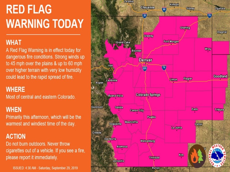
Reminder: there is a Red Flag Warning for today starting at noon and lasting until 7:00pm. The Fire Weather Watch for Monday has been upgraded to a Red Flag Warning. Please do not burn outdoors and avoid activities that could cause a spark! Thank you for helping keep our community safe.
www.weather.gov/bou/weatherstory
www.weather.gov/bou/weatherstory
In case of emergency, please dial 911.
elkcreekfpd.colorado.gov/
Facebook Page
303-816-9385 (Office Hours M-F 8:00-4:30)
This email address is being protected from spambots. You need JavaScript enabled to view it.
Last edit: 29 Sep 2019 09:59 by MyMountainTown. Reason: changed title due to change in status
The following user(s) said Thank You: ScienceChic
Please Log in or Create an account to join the conversation.
- MountainTownAlerts
-
Topic Author
- Mountain Legend
-
Less
More
- Posts: 9766
- Thank you received: 221
30 Sep 2019 07:19 - 30 Sep 2019 07:21 #3
by MountainTownAlerts
Red Flag Warning
URGENT - FIRE WEATHER MESSAGE
National Weather Service Denver/Boulder CO
319 AM MDT Mon Sep 30 2019
...CRITICAL FIRE DANGER AGAIN TODAY DUE TO WARM...DRY AND WINDY CONDITIONS...
...FIRE DANGER REMAINS HIGH ACROSS THE MOUNTAINS AND HIGH VALLEYS TUESDAY AND WEDNESDAY...
COZ213-214-301800-
/O.NEW.KBOU.FW.A.0005.191001T1800Z-191002T0100Z/
/O.CON.KBOU.FW.W.0009.190930T1800Z-191001T0100Z/
Grand and Summit Counties Below 9000 Feet-
Central and Southeast Park County-
319 AM MDT Mon Sep 30 2019
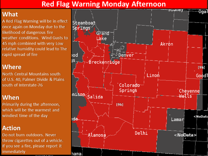
...RED FLAG WARNING REMAINS IN EFFECT FROM NOON TODAY TO 7 PM MDT THIS EVENING FOR WIND AND LOW RELATIVE HUMIDITY FOR MIDDLE PARK AND SOUTH PARK...
...FIRE WEATHER WATCH IN EFFECT FROM TUESDAY AFTERNOON THROUGH TUESDAY EVENING FOR WIND AND LOW RELATIVE HUMIDITY FOR MIDDLE PARK AND SOUTH PARK...
* Affected Area...Fire Weather Zones 213 and 214.
* Winds...Southwest 15 to 25 mph with gusts up to 40 mph.
* Timing...This afternoon, easing at sunset. Fire danger increases again Tuesday afternoon.
* Relative Humidity...As low as 12 percent.
* Impacts...Conditions will be favorable for the rapid ignition, growth, and spread of fires
PRECAUTIONARY/PREPAREDNESS ACTIONS...
A Red Flag Warning means that critical fire weather conditions are either occurring now....or will shortly. A combination of strong winds...low relative humidity...and warm temperatures can contribute to extreme fire behavior.
A Fire Weather Watch means that critical fire weather conditions are forecast to occur. Listen for later forecasts and possible Red Flag Warnings.
URGENT - FIRE WEATHER MESSAGE
National Weather Service Denver/Boulder CO
319 AM MDT Mon Sep 30 2019
...CRITICAL FIRE DANGER AGAIN TODAY DUE TO WARM...DRY AND WINDY CONDITIONS...
...FIRE DANGER REMAINS HIGH ACROSS THE MOUNTAINS AND HIGH VALLEYS TUESDAY AND WEDNESDAY...
COZ212-216-241-245>247-249-301800-
/O.CON.KBOU.FW.W.0009.190930T1800Z-191001T0100Z/
South and Southeast Grand/West Central and Southwest Boulder/Gilpin/Clear Creek/Summit/North and West Park Counties Above 9000 Feet-
Jefferson and West Douglas Counties Above 6000 Feet/Gilpin/Clear Creek/Northeast Park Counties Below 9000 Feet-
Elbert/Central and East Douglas Counties Above 6000 Feet-
Central and East Adams and Arapahoe Counties-
North and Northeast Elbert County Below 6000 Feet/North Lincoln County-
Southeast Elbert County Below 6000 Feet/South Lincoln County-
Washington County-
319 AM MDT Mon Sep 30 2019
...RED FLAG WARNING REMAINS IN EFFECT FROM NOON TODAY TO 7 PM MDT THIS EVENING FOR WIND AND LOW RELATIVE HUMIDITY FOR THE CENTRAL MOUNTAINS...SOUTHERN FRONT RANGE FOOTHILLS...PALMER DIVIDE...AND ADJACENT PLAINS SOUTHEAST OF I-76...
* Affected Area...Fire Weather Zones 212...216...241...245...246...247 and 249.
* Winds...South 15 to 25 mph with gusts up to 40 mph.
* Timing...Winds and fire danger will increase by noon. Winds are expected to remain gusty much of this afternoon before decreasing by dark.
* Relative Humidity...As low as 12 percent.
* Impacts...Conditions will be favorable for the rapid ignition, growth, and spread of fires.
PRECAUTIONARY/PREPAREDNESS ACTIONS...
A Red Flag Warning means that critical fire weather conditions are either occurring now....or will shortly. A combination of strong winds...low relative humidity...and warm temperatures can contribute to extreme fire behavior.
Replied by MountainTownAlerts on topic Red Flag Warning Sunday Sept 29, Monday Sept 30
Red Flag Warning
URGENT - FIRE WEATHER MESSAGE
National Weather Service Denver/Boulder CO
319 AM MDT Mon Sep 30 2019
...CRITICAL FIRE DANGER AGAIN TODAY DUE TO WARM...DRY AND WINDY CONDITIONS...
...FIRE DANGER REMAINS HIGH ACROSS THE MOUNTAINS AND HIGH VALLEYS TUESDAY AND WEDNESDAY...
COZ213-214-301800-
/O.NEW.KBOU.FW.A.0005.191001T1800Z-191002T0100Z/
/O.CON.KBOU.FW.W.0009.190930T1800Z-191001T0100Z/
Grand and Summit Counties Below 9000 Feet-
Central and Southeast Park County-
319 AM MDT Mon Sep 30 2019
...RED FLAG WARNING REMAINS IN EFFECT FROM NOON TODAY TO 7 PM MDT THIS EVENING FOR WIND AND LOW RELATIVE HUMIDITY FOR MIDDLE PARK AND SOUTH PARK...
...FIRE WEATHER WATCH IN EFFECT FROM TUESDAY AFTERNOON THROUGH TUESDAY EVENING FOR WIND AND LOW RELATIVE HUMIDITY FOR MIDDLE PARK AND SOUTH PARK...
* Affected Area...Fire Weather Zones 213 and 214.
* Winds...Southwest 15 to 25 mph with gusts up to 40 mph.
* Timing...This afternoon, easing at sunset. Fire danger increases again Tuesday afternoon.
* Relative Humidity...As low as 12 percent.
* Impacts...Conditions will be favorable for the rapid ignition, growth, and spread of fires
PRECAUTIONARY/PREPAREDNESS ACTIONS...
A Red Flag Warning means that critical fire weather conditions are either occurring now....or will shortly. A combination of strong winds...low relative humidity...and warm temperatures can contribute to extreme fire behavior.
A Fire Weather Watch means that critical fire weather conditions are forecast to occur. Listen for later forecasts and possible Red Flag Warnings.
URGENT - FIRE WEATHER MESSAGE
National Weather Service Denver/Boulder CO
319 AM MDT Mon Sep 30 2019
...CRITICAL FIRE DANGER AGAIN TODAY DUE TO WARM...DRY AND WINDY CONDITIONS...
...FIRE DANGER REMAINS HIGH ACROSS THE MOUNTAINS AND HIGH VALLEYS TUESDAY AND WEDNESDAY...
COZ212-216-241-245>247-249-301800-
/O.CON.KBOU.FW.W.0009.190930T1800Z-191001T0100Z/
South and Southeast Grand/West Central and Southwest Boulder/Gilpin/Clear Creek/Summit/North and West Park Counties Above 9000 Feet-
Jefferson and West Douglas Counties Above 6000 Feet/Gilpin/Clear Creek/Northeast Park Counties Below 9000 Feet-
Elbert/Central and East Douglas Counties Above 6000 Feet-
Central and East Adams and Arapahoe Counties-
North and Northeast Elbert County Below 6000 Feet/North Lincoln County-
Southeast Elbert County Below 6000 Feet/South Lincoln County-
Washington County-
319 AM MDT Mon Sep 30 2019
...RED FLAG WARNING REMAINS IN EFFECT FROM NOON TODAY TO 7 PM MDT THIS EVENING FOR WIND AND LOW RELATIVE HUMIDITY FOR THE CENTRAL MOUNTAINS...SOUTHERN FRONT RANGE FOOTHILLS...PALMER DIVIDE...AND ADJACENT PLAINS SOUTHEAST OF I-76...
* Affected Area...Fire Weather Zones 212...216...241...245...246...247 and 249.
* Winds...South 15 to 25 mph with gusts up to 40 mph.
* Timing...Winds and fire danger will increase by noon. Winds are expected to remain gusty much of this afternoon before decreasing by dark.
* Relative Humidity...As low as 12 percent.
* Impacts...Conditions will be favorable for the rapid ignition, growth, and spread of fires.
PRECAUTIONARY/PREPAREDNESS ACTIONS...
A Red Flag Warning means that critical fire weather conditions are either occurring now....or will shortly. A combination of strong winds...low relative humidity...and warm temperatures can contribute to extreme fire behavior.
Last edit: 30 Sep 2019 07:21 by MountainTownAlerts.
Please Log in or Create an account to join the conversation.
- Forum
- Life Up the Hill
- Scanner & Emergency Info, Weather Forecasts
- Red Flag Warning Sunday Sept 29, Monday Sept 30
Time to create page: 0.183 seconds
sponsors


